Exercise 4: The route back to civilisation


Page12

The objective of this activity is to study the escape route the survivors chose, discuss their decision, and assess the difficulties they encountered.
 
The resources needed for this exercise are the following:

  • Landsat images in full resolution (as in the previous exercise)
  • Series of low resolution Landsat images LEOWorks image processing software
  • Google Earth

Deciding whether to go east or west was difficult for the survivors. They thought they were much further to the west than they actually were. In fact, they thought they were somewhere in the foothills deep in the Chilean territory, when they were actually in Argentina. Their erroneous belief was based on the information given to them by the co-pilot, who passed away shortly after the crash.

Describe the landscape where the survivors were stranded. Use satellite images and Google Earth to help you.


1. How mountainous is the area where the plane crashed?

2. Find the border between Argentina and Chile. In which country was the wrecked fuselage?

3. In which direction did the survivors decide to walk?

4. The survivors waited over two months before starting to walk. What was their reason for hesitating so long? Consider the change of season in the area from the (reduced resolution) Landsat images in natural colours below.


Andes in September
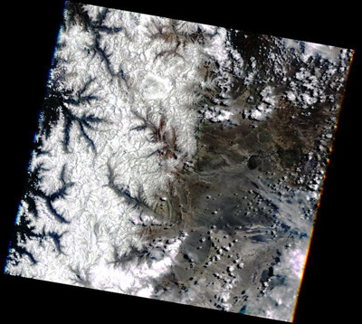
 Andes in September
Andes in November Andes in November


Andes in DecemberAndes in December
Andes in JanuaryAndes in January


These Landsat images are included in Andes.zip file. You can run these images as an Animation. After loading them, regulate the animation speed to a minimum.
 
 
Page12


Last update: 16 April 2013


Lost in the Andes!

 •  Lost in the Andes (http://www.esa.int/SPECIALS/Eduspace_Global_EN/SEMPSH52Q8H_0.html)
 •  Introduction (http://www.esa.int/SPECIALS/Eduspace_Global_EN/SEMFUH52Q8H_0.html)
 •  Background (http://www.esa.int/SPECIALS/Eduspace_Global_EN/SEM0YH52Q8H_0.html)

Exercises

 •  Exercise 1: The Andean region (http://www.esa.int/SPECIALS/Eduspace_Global_EN/SEMA8I52Q8H_0.html)
 •  Exercise 2: Vegetation cover (NDVI) (for university students) (http://www.esa.int/SPECIALS/Eduspace_Global_EN/SEMJSX52Q8H_0.html)
 •  Exercise 3: The geographical setting of the accident (http://www.esa.int/SPECIALS/Eduspace_Global_EN/SEM2O962Q8H_0.html)
 •  Exercise 5: Expedition “Alive!” (http://www.esa.int/SPECIALS/Eduspace_Global_EN/SEMFIC62Q8H_0.html)
 •  Exercise 6: A multidisciplinary workshop (http://www.esa.int/SPECIALS/Eduspace_Global_EN/SEMABF62Q8H_0.html)

Eduspace - Software

 •  LEOWorks 3 (http://esamultimedia.esa.int/multimedia/LEOWorks3.exe)
 •  LEOWorks 4 (MacOS) (http://leoworks.asrc.ro/download/leoworks.app.zip)
 •  LEOWorks 4 (Windows) (http://leoworks.asrc.ro/download/leoworks.exe)
 •  LEOWorks 4 (Linux) (http://leoworks.asrc.ro/download/leoworks.jar)

Eduspace - Download

 •  Lost_in_the_Andes.zip (http://esamultimedia.esa.int/eduspace/Lost_in_the_Andes.zip)

More on the Andes tragedy

 •  Wikipedia summary (http://en.wikipedia.org/wiki/1972_Andes_flight_disaster)