
Overview - working on paper prints

This excercise is divided into two parts and does not require the use of LEOWorks.
Part 1
All the data you will need is compressed in the file 'bardia_paperprints.zip'.
Print the following files in colour:
- ENVISAT_MERIS_20060224_false_colour_infrared.jpg
- Bardia_landsat_1990_band _453_120m_Park_boundary.png
- Bardia_landsat_2002_band _453_120m_Park_bounddary.png
The Bardia National Park is located in the Terai and Siwalik region in a protected area network of Nepal. It covers the floodplain of the Karnali River, Babai valley and surrounding hills.
Read more about the BNP in the Background section.
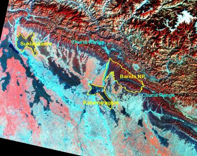 |
MERIS image of the Bardia National Park's boundaries in 2006
|
The infrared false colour image shows the western mountains and the Terai. Rivers and riverbeds, and the fallow crop field areas in the plain are light blue, but irrigated fields appear in light red. Forests and extensively used pasture land are very dark/black, but forests on the foot hills appear in distinctive belts of different shades of red, depending on the altitude, and thus the prevailing species. Light yellow represents the pasture and agricultural land in the hills. Some clouds are also visible in white.
The image shows that there are isolated forest patches in flat Terai (dark red). In the Churia or Siwalik Hills, which form the most southern Himalayan ranges and also the hilly part of the Bardia National Park (BNP), the forest is uninterrupted from east to west. This forest corridor in the Churia ranges connects the BNP with the Suklaphanta wildlife reserve in the west, and the Chitwan National Park in the east. These are not seen in the image though. Similarly, a very narrow stripe of forest running from Bardia to the south connects it to the Katarniyaghat Wildlife Sanctuary in India.
1. Take a map of Nepal in your school atlas and compare the topography shown in the image with the one on the map. Having studied the background section of this case study, try to divide the image in at least 5 morphological zones:
- floodplain (Terai)
- southern hills (Siwalik)
- inner hilly zone of the Middle Mountains (Mahabharat)
- the High Mountain chains
- the Himalayas, the rocky ice and snow mountains towards the northern border
2. Describe and characterise these zones.
3. Can you also distinguish them on your map?
4. In the image, find and describe rivers, the different types of forests, clouds, and areas with crop fields. Explain the difference in the colour of the crop fields.
Last update: 16 April 2013
| |
Bardia National Park
| | • | Introduction (http://www.esa.int/SPECIALS/Eduspace_Global_EN/SEM67NKRQJF_0.html) | | | • | Location (http://www.esa.int/SPECIALS/Eduspace_Global_EN/SEMVZNKRQJF_0.html) | | | • | Geology and soil (http://www.esa.int/SPECIALS/Eduspace_Global_EN/SEMH5OKRQJF_0.html) | | | • | Weather and climate (http://www.esa.int/SPECIALS/Eduspace_Global_EN/SEMNGPKRQJF_0.html) | | | • | People and settlements (http://www.esa.int/SPECIALS/Eduspace_Global_EN/SEMF3Q6UWJF_0.html) | |
Exercises
| | • | Worksheet introduction (http://www.esa.int/SPECIALS/Eduspace_Global_EN/SEM5HQ6UWJF_0_ov.html) | | | • | Bardia Region Overview - Image processing (http://www.esa.int/SPECIALS/Eduspace_Global_EN/SEMH8T6UWJF_0.html) | | | • | Landscape and land cover dynamics in the Karnali Floodplain (http://www.esa.int/SPECIALS/Eduspace_Global_EN/SEMU4X6UWJF_0.html) | | | • | Habitat suitability evaluation for rhinoceros in Bardia (http://www.esa.int/SPECIALS/Eduspace_Global_EN/SEM5LX6UWJF_0.html) | |
Eduspace - Software
| | • | LEOWorks 3 (http://esamultimedia.esa.int/multimedia/LEOWorks3.exe) | | | • | ArcExplorer (http://esamultimedia.esa.int/multimedia/eduspace/ae2setup.zip) | |
Eduspace - Download
| | • | bardia.zip (http://download.esa.int/multimedia/eduspace/bardia_v2.zip) | | | • | bardia_paperprints.zip (http://esamultimedia.esa.int/docs/eduspace/bardia_paperprints.zip) | |
Resources
| | • | Useful links (http://www.esa.int/SPECIALS/Eduspace_Global_EN/SEMEIY6UWJF_0.html) | |
|
