Glacier change is one of the best indicators of climate change. Knowing how glaciers are changing worldwide gives a good idea of the climatic changes in glacier regions.
Glacier changes can have an impact on hazard situations, for instance with new or growing glacier lakes. They can also have an impact on the dry-season runoff of rivers that source from these glaciers, and consequently on the water availability in the downstream areas.
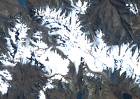
All of these effects (and more) are important for the South American Andes. In this exercise you will be working with two Landsat satellite images of glaciers in the Andes of South America. You will try to detect glacier change. Familiarise yourself with the study area using the GoogleEarth file which can be downloaded from the right menu.
This case study has a total of six exercises:
1. Inspection of true colour RGB composites
2. Animation
3. Band Arithmetic
4. GIS
5. Measurement of area
6. Multitemporal image
The exercises are prepared for the use of LEOWorks 4.
Data
In order to complete the exercises, you will need the following images:
Landsat TM, bands 1,2 and 3 (3 September 1988)
tm_03sept1988_band321.tif
tm_03sept1988_band1.tif (blue band)
tm_03sept1988_band2.tif (green band)
tm_03sept1988_band3.tif (red band)
Landsat ETM+, bands 1,2 and 3 (30 July 2010)
etm_30july2010_band321.tif
etm_30july2010_band1.tif (blue band)
etm_30july2010_band2.tif (green band)
etm_30july2010_band3.tif (red band)
 | |
Climate change and glaciers
|
| • | Introduction (http://www.esa.int/SPECIALS/Eduspace_Global_EN/SEMJWGH2SDH_0.html) |
|
| • | Background (http://www.esa.int/SPECIALS/Eduspace_Global_EN/SEMJXGH2SDH_0.html) |
|
Exercises
|
| • | Exercise 1: Inspection of true colour RGB composites (http://www.esa.int/SPECIALS/Eduspace_Global_EN/SEMIAJH2SDH_0.html) |
|
| • | Exercise 2: Animation (http://www.esa.int/SPECIALS/Eduspace_Global_EN/SEMUEJH2SDH_0.html) |
|
| • | Exercise 3: Band Arithmetic (http://www.esa.int/SPECIALS/Eduspace_Global_EN/SEMMFJH2SDH_0.html) |
|
| • | Exercise 4: GIS (http://www.esa.int/SPECIALS/Eduspace_Global_EN/SEMDHJH2SDH_0.html) |
|
| • | Exercise 5: Measurement of area (http://www.esa.int/SPECIALS/Eduspace_Global_EN/SEMPIJH2SDH_0.html) |
|
| • | Exercise 6: Multitemporal analysis (http://www.esa.int/SPECIALS/Eduspace_Global_EN/SEMDKJH2SDH_0.html) |
|
| • | Conclusions (http://www.esa.int/SPECIALS/Eduspace_Global_EN/SEMFTKH2SDH_0.html) |
|
Eduspace - Software
|
| • | LEOWorks 4 (MacOS) (http://leoworks.asrc.ro/download/leoworks.app.zip) |
|
| • | LEOWorks 4 (Linux) (http://leoworks.asrc.ro/download/leoworks.jar) |
|
| • | LEOWorks 4 (Windows) (http://leoworks.asrc.ro/download/leoworks.exe) |
|
Eduspace - Download
|
| • | Andes_images.zip (http://esamultimedia.esa.int/docs/eduspace/Andes_images.zip) |
|
| • | GoogleEarth file (http://esamultimedia.esa.int/multimedia/GoogleEarth_file eduspace_glacier.kmz) |
|