|
SPOT VEGETATION imagery The SPOT VEGETATION Programme consists of two observation instruments in orbit, VEG 1 and VEG 2, as well as ground infrastructures. The first of the two instruments in orbit is aboard the SPOT 4 satellite, launched in 1998. The second is aboard SPOT 5, placed in orbit in 2002. The overall objective of the VEGETATION system is to provide accurate measurements of the basic characteristics of vegetation canopies on an operational basis,
Radiometry
The VEGETATION product used here is the VGT-S product, which takes into account some synthesis capability between successive orbits, either on the same day or on different days. Data is processed to extract the best possible measurement for a given period following carefully chosen criteria. Two types of standard products were defined:
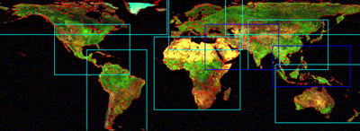
1. a daily synthesis (VGT-DS), with ground reflectance and NDVI computed from the ground reflectances Both standard products are global onland processes that provide a standard, geometric sampling preserving the 1km raw data resolution. Syntheses were done through selection of the best measurement acquired during one day or a 10-day period: the composite is made using the maximum NDVI values, index that was calculated using top of the atmosphere reflectances. A window over the South American continent was defined from the global product (see figure below).
Last update: 16 April 2013
| ||||||||||||||||||||||||||||||||||||||||||||||||||||||