|
Exercise 4: Change detection in the mainland part of the delta Changes occurring at the Sf. Gheorghe mouth are fast and can be measured very well from Landsat images. From the previous examples we saw that the secondary delta has grown in time. If on the shore we could find such rapid changes, would we also find changes in the delta? To answer this let’s take a look at the images from 1984 and 2000, in the area of the secondary delta. Open the two images 432_1984.tif and 432_2000.tif.


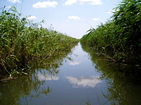
Landsat images from 1984 (left) and 2000 (right) showing changes in the Seredne branch of the delta (USGS, ASRC) We can see that the secondary delta comprises two branches: Turetski (or Turkish Branch) and Seredne (which means Middle Branch). Their width seems somewhat similar, the only noticeable difference is in the width of the top part of Seredne, which appears to be less than 30m in the 2000 image (see the yellow arrows). Below is a picture of this area as it looked at the time this case study was produced.
How do you explain the narrowing of the Seredne branch? Why has the Turetski arm not changed so much since the 1984 acquisition? Hint: To correctly answer this you must keep in mind the evolution of the Sacalin Island.
The answer is very simple: in the past the island was heading away from the mouth of Seredne. So, through erosion and movement to the west, the island obstructed the river mouth. Unable to flow into the sea, the Seredne branch filled with mud and its width was reduced. The amount of discharge is very little and the reed will, over time, transform Seredne into a marsh. Even though the depth at the Turetski mouth is low, it still carries water and maintains its functionality. For this reason it has not been clogged up.


Landsat image acquired in 1984 showing a channel cut through the branch of St George. (USGS, ASRC)
The creation of this channel led to a decrease in the velocity of water along the natural bend. Increasing current velocity along the new channel, erosion will be higher along the bottom causing the channel to become deeper towards the upstream and downstream. Because a significant volume of water will leave the natural meanders and flow with high speed into the channel, in time processes of sediment deposition will take place accompanied by a decrease in the depth. Conclusions Change detection is a powerful technique for environmental studies. Using LeoWorks you can understand the evolution of a barrier island and the coastal morphodynamics at the river-sea boundary. Landsat images have proved to be useful and represent an important resource for geographical projects. Since 2008, these images have been freely available using the Earth Explorer or Glovis websites. Knowledge of terrain is required to validate the results of change detection studies. Last update: 16 April 2013
| ||||||||||||||||||||||||||||||||||||||||||||||||||||||||||||||||||||||||||||||||||