
Annapurna Conservation Area - background

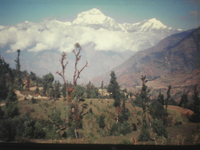 | |
Dhaulagiri, one of the highest mountains in the world
| |
The Annapurna Conservation Area (ACA), which is located in the Western Himalayas, covers an area of 7,629 km². The ACA is the catchment area for three major rivers and contains the deepest river valley, the Kali Ghandaki, and two of the highest mountains in the world, Annapurna I (8,091 m) and Dhaulagiri (8,167 m). The Annapurna Circuit, one of the best known in the world and Nepal's major trekking route, borders the ACA.
The geographical features of the terrain provide many microclimates, ranging from sub-tropical conditions in the south to alpine steppe and arid conditions in the north. The biological diversity is illustrated by a King Mahendra Trust for Nature Conservation (KMTNC) 1994 study, identifying over 1,200 plant species, 101 mammals, 474 bird species, 39 reptile species and 22 amphibian species. These include the endangered snow leopard, blue sheep, musk deer and over 100 varieties of orchid.
The ACA's biological diversity is matched by its cultural diversity. The area has a population of more than 120,000 inhabitants from more than 10 ethnic groups. The population is mainly sustained by agriculture, with livestock rearing as a secondary occupation. The majority of the population lives at subsistence level, with a high level of dependence on natural resources. Over 90% of local energy needs are met by the forests.
| 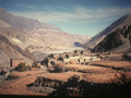 | | |
Treeless mountains around Kagbeni
|
That is why the region is experiencing environmental problems. The number of visitors has increased dramatically from about 14,000 in 1980, to 43,000 in 1994, to more than 67,000 in 1999. The ACA attracts more than 55% of all trekkers visiting Nepal, with three times as many people visiting the ACA compared to the second most popular destination, Mount Everest. Due to additional staff employed by trekkers, such as porters and guides, the total number of hikers visiting the ACA each year is higher than the local population.
The local population is not as wealthy as its visitors. However, the latter bring money into the region and the locals have developed a trekking infrastructure. They have built lodges, hotels and restaurants, even in locations that are difficult to access. There are hot showers 4,000 m above sea level, and menus that leave nothing to be desired. Many of the sparse forests were cleared to assure these comforts. The subsequent erosion has caused many devastating landslides.
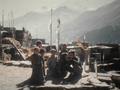 | |
Children awaiting trekkers near Tengi
| |
A second problem is garbage. Trekkers leave up to 200,000 plastic bottles lying around the area each year. The bottles are not carried down into the cities for waste disposal. On the contrary, they are dumped behind the lodges and along the track, and remain there indefinitely.
Luckily the ACA has understood the importance of implementing strategies to promote sustainable tourism in order to continue to benefit from it. Following environmental pressure in the 1980s, the ACA was recognised as requiring protected status in order to prevent excessive environmental degradation. With this in mind, the KMTNC established the Annapurna Conservation Area Project (ACAP) in 1986.
The long-term objectives of the ACAP are:
- to conserve the natural resources of the ACA for the benefit of present and future generations
- to bring sustainable social and economic development to the local people
- to develop tourism in such a way that it will have a minimum negative environmental impact
(KMTNC 1990 / ACAP 2002)
The Annapurna Circuit itself is a mild to moderate 16 to 21-day route. It is not a mountaineering trip and no technical ability is required. The only substantial problem could be the risk of altitude sickness.
| 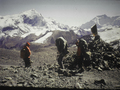 | | |
Thorong La at 5,416 metres
|
The route leads up to a maximum altitude of 5,416 m at Thorong La, whereas the average altitude is only 2,800 m. There are lots of lodges and tea houses along the route, so no one has to fear going hungry or thirsty. Most trekkers book a guided tour which includes transport, accomodation, meals, guides and porters. The Annapurna Circuit is a route suitable for everyone, making it the major trekking route in Nepal.
You can find many websites regarding the Annapurna Circuit by browsing the internet.
Last update: 16 April 2013
| |
Annapurna Conservation Area
| | • | Introduction (http://www.esa.int/SPECIALS/Eduspace_Global_EN/SEM0V2XPXPF_0.html) | |
Exercises
| | • | Worksheet introduction (http://www.esa.int/SPECIALS/Eduspace_Global_EN/SEMHX2XPXPF_0.html) | | | • | Annapurna Region Overview (http://www.esa.int/SPECIALS/Eduspace_Global_EN/SEMGY2XPXPF_0.html) | | | • | Annapurna Circuit (http://www.esa.int/SPECIALS/Eduspace_Global_EN/SEMEZ2XPXPF_0.html) | | | • | Annapurna I Region (http://www.esa.int/SPECIALS/Eduspace_Global_EN/SEMG03XPXPF_0.html) | | | • | Pokhara Region (http://www.esa.int/SPECIALS/Eduspace_Global_EN/SEM823XPXPF_0.html) | | | • | Thorung La Region (http://www.esa.int/SPECIALS/Eduspace_Global_EN/SEMYC3XPXPF_0.html) | |
Eduspace - Software
| | • | LEOWorks 3 (http://esamultimedia.esa.int/multimedia/LEOWorks3.exe) | | | • | ArcExplorer (http://esamultimedia.esa.int/multimedia/eduspace/ae2setup.zip) | |
Eduspace - Download
| | • | annapurna.zip (http://esamultimedia.esa.int/multimedia/eduspace/annapurna.zip) | | | • | AnnapurnaGIS.zip (http://esamultimedia.esa.int/docs/eduspace/AnnapurnaGIS.zip) | | | • | subuint_annapurna.zip (http://esamultimedia.esa.int/docs/eduspace/subuint_annapurna.zip) | |
|
