|
Exercise 4 - Help, the icebreaker is stuck!
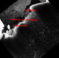
Have a look at the reduced resolution image representing an area of 400 x 400 km, acquired on 16 November 2003. The icebreaker's position on its way to Davis Station on 19 November at 0900 GMT, as well as the location of the two research stations visited, are indicated in red. The ice situation only slightly changed in the 3 days between acquisition of the satellite data and arrival of the ship. The bright area to the left is the Amery Ice Shelf. Such ice is attached to land but projects out to the sea. You can find more about ice types in the Background chapter of this module. For more information about shelf ice, see: www.agu.org/pubs/sample_articles/sp/2000JB000058/2.shtml Download ant2003_ex18.zip (0.2 Mb) .The radar image shows 190 km coast line of Antarctic icy beauty, centered at 77 degrees East. It was acquired on 16 November 2003 and has been reduced to a spatial resolution of 375 m. Study the different types of glaciers, the ones in strong movement, and the ones with apparently little changes.
Explain why some glaciers have rough and brocken tongues. Think of a floating terminal part. Study the different sea ice types. Locate the two research stations visited by the Antarctica 2003 expedition, Zhong and Davis, by their bright spots on the rocky shores, using the annotated low-resolution image also found on this page. This image was not available to the ship. If it had been, which direction would the captain have chosen? Download ant2003_ex19.zip (2.1 Mb), and print this image, and trace the best way through the ice from the ship's position on 19 November at 09.00 GMT to Davis Station. Last update: 18 April 2013
| ||||||||||||||||||||||||||||||||||||||||||||||||||||||||||||||||||||||||