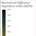
Exercise 2: Vegetation cover (NDVI) (for university students)


The objective of this exercise is to study the density of the vegetation found in this area of South America, and to correlate vegetation and regional climate.
 
You should now observe satellite data collected during different seasons. We do not use real images for this. Instead, we will look at “Normalized Vegetation Index” images, which show the density of vegetation cover.

In order to do this exercise you will need the following:

  • July_NDVI_Latin_America.tif
  • January_NDVI_Latin_America.tif
  • MERIS_FR_20070318……annotated.tif or GIS-files
  • LEOWorks image processing software

Display the two NDVI images and the annotated MERIS image in LeoWorks. Look at the two NDVI images carefully.

Vegetation Index July Vegetation Index July
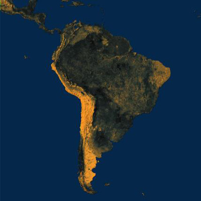
Vegetation Index JanuaryVegetation Index January


1. Which of these images represents summer, and which represents winter?


NDVI legend
 
NDVI legend
 
 
Justify your answer by explaining what elements you used to come to this conclusion. Use the thematic maps of your Atlas. Remember: the greener the image, the denser and stronger the vegetation cover!
 
 
With the help of the cursor, find the geographic area we have been studying.

2. What are the differences between the eastern and western side of the Andes, and between winter and summer?

Discuss these eastern and western differences along the other parts of the mountain range.

Explain the differences found in the different sections (southern, central, and northern) of the image.

Use the other high resolution MERIS image showing the location of the accident. (In LEOWorks4 click on “Synchronise cursor position”.)

Load the two NDVI images in the Animation tool and flicker the two images. Regulate the speed of the animation.


Last update: 16 April 2013


Lost in the Andes!

 •  Lost in the Andes (http://www.esa.int/SPECIALS/Eduspace_Global_EN/SEMPSH52Q8H_0.html)
 •  Introduction (http://www.esa.int/SPECIALS/Eduspace_Global_EN/SEMFUH52Q8H_0.html)
 •  Background (http://www.esa.int/SPECIALS/Eduspace_Global_EN/SEM0YH52Q8H_0.html)

Exercises

 •  Exercise 1: The Andean region (http://www.esa.int/SPECIALS/Eduspace_Global_EN/SEMA8I52Q8H_0.html)
 •  Exercise 3: The geographical setting of the accident (http://www.esa.int/SPECIALS/Eduspace_Global_EN/SEM2O962Q8H_0.html)
 •  Exercise 4: The route back to civilisation (http://www.esa.int/SPECIALS/Eduspace_Global_EN/SEM3RB62Q8H_0.html)
 •  Exercise 5: Expedition “Alive!” (http://www.esa.int/SPECIALS/Eduspace_Global_EN/SEMFIC62Q8H_0.html)
 •  Exercise 6: A multidisciplinary workshop (http://www.esa.int/SPECIALS/Eduspace_Global_EN/SEMABF62Q8H_0.html)

Eduspace - Software

 •  LEOWorks 3 (http://esamultimedia.esa.int/multimedia/LEOWorks3.exe)
 •  LEOWorks 4 (MacOS) (http://leoworks.asrc.ro/download/leoworks.app.zip)
 •  LEOWorks 4 (Windows) (http://leoworks.asrc.ro/download/leoworks.exe)
 •  LEOWorks 4 (Linux) (http://leoworks.asrc.ro/download/leoworks.jar)

Eduspace - Download

 •  Lost_in_the_Andes.zip (http://esamultimedia.esa.int/eduspace/Lost_in_the_Andes.zip)

More on the Andes tragedy

 •  Wikipedia summary (http://en.wikipedia.org/wiki/1972_Andes_flight_disaster)