|
Kilimanjaro - Worksheet - Continued
We will measure the amount of deforestation, first based on the 2000 images and then on the 1984 images. 6) Measure the amount of deforestation in 2000. Open the Kilim432 false colour image or the Kilim 321 natural colour image you constructed and saved above. We will now measure the deforested area at the Western slope of Kilimanjaro inside the Forest Reserve.
Choose Image/Measure tool and select
The perimeter and the area is shown in the Measure tool window.
7) Measure the amount of deforestation in 1984.
Open the Kilim432 false colour image or the Kilim 321 natural colour image you constructed and saved above.
In the United Nations Development Programme (UNEP) study "Aerial Survey of the threats to Mt. Kilimanjaro", scientists in 2000 conducted an extensive survey regarding threats to the area. The scientists flew over the whole Forest Reserve in a small aircraft and observed and photographed all the impacts on the forest. Using a Global Positioning System (GPS), all their measurements and photographs are georeferenced and transferred to GIS files to be opened and overlayed on satellite images in LEOWorks. The types of damages and threats to the forest were recorded as follows:
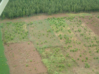
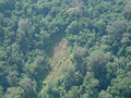
The survey recorded recent logging of indigenous trees in the natural forest. Two of the most targeted species were identified separately: camphor (Ocotea usambarensis) and cedar (Juniperus procera). The others are grouped under the category "other indigenous tree species". Burnt forest areas The survey recorded 65 burnt indigenous forest areas. The fires had usually taken place some time ago. The majority of these areas were found on the southwestern slopes of Mt. Kilimanjaro. Charcoal Some 125 charcoal kilns were spotted in the natural forest of Mt. Kilimanjaro. All the kilns were located on the southeastern slopes . Shamba (Taungya) system Forest plantations in Tanzania have usually been established by allowing local farmers to intersperse annual agricultural crops with tree seedlings in forest plantation areas until the third year of tree growth. By the third year, the young tree canopy casts too much shade for the normal growth of agricultural crops. At this point, farmers move out and are allocated another plot, if available.
This Shamba system is based on the successful experience of establishing teak plantations in Burma (Myanmar) since the middle of the 19th century. It was identified as a means of providing cheap, or even free, labour for establishing forest plantations, contributing to national food production and the creation of rural employment. Last update: 16 April 2013
| ||||||||||||||||||||||||||||||||||||||||||||||||||||||||||||||||