
Study area

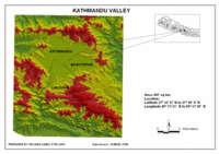 | |
Overview of the Kathmandu valley (red area above 1800 m.s.l.)
| |
Kathmandu valley is roughly elliptical in shape, 25 kilometres along its east-west axis, and has a maximum width of 19 kilometres. It lies in the lesser Himalayas of Central Nepal. The valley lies at a mean elevation of about 1350 m above the sea level. The bowl shaped topography of Kathmandu valley is surrounded by mountains on all sides. Some of the surrounding hills having heights of more than 2000 m are Shivapur in the north, Nagarkot in the east, Phulchoki in the south and Chandragiri Ridge in the west. They also include various passes viz. Bhimdhunga and Sanga.
The valley comprises three administrative districts, namely Kathmandu, Bhaktapur, and Lalitpur. Its population is 1,645,091 inhabitants (Census 2001).
The climate of the valley is subtropical, continental, and semi-humid (Lauer/Frankenberg classification). The average temperature that the valley experiences is 18.3˚C, while the main annual rainfall is 1439.7 mm
| 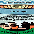 | | |
Atmospheric inversion
|
Air Pollution in the Kathmandu valley
Kathmandu, the capital city of Nepal, is the centre foci for all the major facets of the country, namely economy, tourism, culture, politics, administration, and the natural environment. This has resulted in rapid air pollution due to high influx of rural population, urbanisation, valley-centric industrialisation, and significant burgeoning of vehicular traffic in the narrow streets.
Furthermore, the bowl-shaped topography of the valley restricts the wind movements and retains the air pollutants in the atmosphere, adding to the urban air quality burden. Several studies have also shown that the quality of the air in Kathmandu valley has been deteriorating over the past decade.
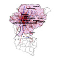 | |
Air Monitoring Stations
| |
As of October 2002, with the help of the Danish government (DANIDA), the former Ministry of Environment and Population (HMG/MOPE) has taken the initiative of launching an air quality management programme within the Kathmandu valley. It has established six air quality monitoring stations within the valley. The main aim of establishing these air monitoring stations is to create public awareness about air quality.
 |
Air quality monitoring stations in the Kathmandu valley
|
In the following exercises you will learn how to study air pollution. We will concentrate on the Kathmandu valley as an example. By doing these exercises, you will then be able to do a similar study of your city in order to know more about the quality of its air.
Last update: 16 April 2013
| |
Kathmandu Valley
| | • | Introduction (http://www.esa.int/SPECIALS/Eduspace_Global_EN/SEMFLK0SAKF_0.html) | | | • | Air Pollution (http://www.esa.int/SPECIALS/Eduspace_Global_EN/SEMBPK0SAKF_0.html) | |
Exercises
| | • | Introduction (http://www.esa.int/SPECIALS/Eduspace_Global_EN/SEMM5L0SAKF_0_ov.html) | | | • | Exercise 1 (http://www.esa.int/SPECIALS/Eduspace_Global_EN/SEM9BL0SAKF_0.html) | | | • | Exercise 2 (http://www.esa.int/SPECIALS/Eduspace_Global_EN/SEMIHL0SAKF_0.html) | | | • | Exercise 3 (http://www.esa.int/SPECIALS/Eduspace_Global_EN/SEMIRL0SAKF_0.html) | |
Links
| | • | Useful links (http://www.esa.int/SPECIALS/Eduspace_Global_EN/SEMO8M0SAKF_0.html) | |
Eduspace - Software
| | • | LEOWorks 3 (http://esamultimedia.esa.int/multimedia/LEOWorks3.exe) | | | • | ArcExplorer (http://esamultimedia.esa.int/multimedia/eduspace/ae2setup.zip) | |
Eduspace - Download
| | • | Fig. 7.1 - 7.10 (zip file) (http://esamultimedia.esa.int/docs/eduspace/Fig7_1-10.zip) | | | • | MERIS images of Kathmandu valley (zip file) (http://esamultimedia.esa.int/docs/eduspace/Kathmandu_airpollution_Ex-3.zip) | |
|
