
Exercise 3: Band Arithmetic

 | |
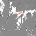
1988-2010
| |
Using Open Multiple Files as Single Dataset, open tm_03sept1988_band1.tif and etm_30july2010_band1.tif.
Subtract one image from the other to analyse the changes. Use the blue band (band1).
Select the tool Band Arithmetic.
Edit the expression in this way:
tm_03sept1988_band1.tif - etm_30july2010_band1.tif
In the subtracted image, no changes or little changes are displayed in grey (medium brightness). Strong changes are either displayed as bright or dark areas, depending on whether the change in time is from a bright surface (e.g. ice) to a dark surface (e.g. moraine) or vice versa.
The bigger the differences between the images, the brighter or darker the resulting image.
There are other factors besides glacier changes that can have an effect on image differences. For example, different illumination conditions which are due to different months when the image was taken can have an effect on shadows of steep crests, leading to different sizes. This difference is marked as a bright change in the resulting subtracted image. However, glacier surface change is a much more significant change that becomes visible with the white zones around the glaciers. The black areas in the southwestern part of the image are the result of new snow.
|  | | |
Measurement of retreat length
|
Study the subtracted image and analyse the glacier changes. Compare your findings to the findings you obtained in Exercise 2, or by observing both colour images at the same time.
1. Is the glacier with the biggest changes (i.e. with the largest bright change area) the same as the one you identified as having the biggest change in the animation?
2. Find a changed glacier lake. Is its changed colour bright or dark? Why is that?
3. Measure the retreat length of some glaciers in the subtracted image using the Measurement tool.
Last update: 16 April 2013
| |
Climate change and glaciers
| | • | Introduction (http://www.esa.int/SPECIALS/Eduspace_Global_EN/SEMJWGH2SDH_0.html) | | | • | Background (http://www.esa.int/SPECIALS/Eduspace_Global_EN/SEMJXGH2SDH_0.html) | |
Exercises
| | • | Worksheet introduction (http://www.esa.int/SPECIALS/Eduspace_Global_EN/SEM5ZGH2SDH_0.html) | | | • | Exercise 1: Inspection of true colour RGB composites (http://www.esa.int/SPECIALS/Eduspace_Global_EN/SEMIAJH2SDH_0.html) | | | • | Exercise 2: Animation (http://www.esa.int/SPECIALS/Eduspace_Global_EN/SEMUEJH2SDH_0.html) | | | • | Exercise 4: GIS (http://www.esa.int/SPECIALS/Eduspace_Global_EN/SEMDHJH2SDH_0.html) | | | • | Exercise 5: Measurement of area (http://www.esa.int/SPECIALS/Eduspace_Global_EN/SEMPIJH2SDH_0.html) | | | • | Exercise 6: Multitemporal analysis (http://www.esa.int/SPECIALS/Eduspace_Global_EN/SEMDKJH2SDH_0.html) | | | • | Conclusions (http://www.esa.int/SPECIALS/Eduspace_Global_EN/SEMFTKH2SDH_0.html) | |
Eduspace - Software
| | • | LEOWorks 4 (MacOS) (http://leoworks.asrc.ro/download/leoworks.app.zip) | | | • | LEOWorks 4 (Linux) (http://leoworks.asrc.ro/download/leoworks.jar) | | | • | LEOWorks 4 (Windows) (http://leoworks.asrc.ro/download/leoworks.exe) | |
Eduspace - Download
| | • | Andes_images.zip (http://esamultimedia.esa.int/docs/eduspace/Andes_images.zip) | | | • | GoogleEarth file (http://esamultimedia.esa.int/multimedia/GoogleEarth_file eduspace_glacier.kmz) | |
| 