|
Habitat suitability evaluation for rhinoceros in Bardia - Part 3 This GIS exercise is divided into three parts and requires the use of ArcExplorer. ArcExplorer is a 'display' tool, and does not allow you to update the GIS-layer as a professional software would do. However, LEOWorks has some GIS functionalities which allow you to display and generate GIS layers. Exercise using LEOWorks and its GIS functions
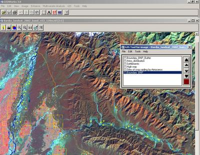
Close all ArcExplorer programmes (this is very important!). Open the LEOWorks software. Choose File>Open..., select the folder 'GIS_Habitat' and open the image Bardia_landsat_2002_band_453_120m.tif. Press the GIS button and Open Theme. Load several themes, such as:
Change the properties of the theme 'Rhino-distribution' by clicking on the theme, then Edit>Properties. Click on the colour bar and change to yellow, click Symbol and change to Period (Dot). Apply OK. Change the properties of the theme 'Highway' by selecting an orange colour. Change the properties of the theme 'Settlements' by selecting an orange colour, click Symbol and change to Square. Apply OK. Now generate Bufferzones of different width along the border of the park to highlight the conflict between animals and humans. Click on the layer 'Boundary_BNP' in the GIS Tool for image…..window. Click Tool>Bufferzone. Select metres instead of pixel(s) and replace 5 by 100 (metre), OK. You can see the bufferzone of the width of 100 metres. In the same way, generate a Bufferzone of 500 m and 1000 m.
1. Which is the zone with the most infringes of Rhinos into Settlements?
2. Do the same with the highway. Is there any conflict? Generate a Bufferzone around the rhino-distribution (sightings of rhinos). Switch off the Boundary_BMP_Buffer by double-clicking on the theme in the GIS Tool for image…..window. You can also measure the distances from the sightings to the Park border.
3. Make a brief report of your observations and discuss the matter with your classmates. Find solutions to minimise animal-human conflicts.
Last update: 16 April 2013
| ||||||||||||||||||||||||||||||||||||||||||||||||||||||||||||||||||||||||||||