Oil spills


Ship dumping sewage in the North Sea


Each year, ships and industry damage the delicate coastal ecosystem in many parts of the world by releasing oil or pollutants into rivers and coastal waters. Off-shore environments are also polluted by mineral oil mainly due to:
  • tanker accidents, where large amounts of oil are spilled into the sea
  • illegal oil discharges by ships during their 'normal operations'
  • natural oil seepage
After a tanker accident, the biggest problems encoutered are the difficulty in obtaining an overall view of the affected area, getting a clear idea of the extent of the slick, and predicting the direction in which it will move.
 
 
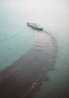
For natural oil spills and those caused by humans, it is necessary to operate a regular monitoring programme. Aerial surveys over large areas (e.g. the Mediterranean Sea) to check for the presence of oil are limited to daylight hours and good weather conditions.

The Mediterranean Sea has extensive marine traffic because it gives maritime access to the Middle East and the Suez Canal, the Black Sea and Southern Europe. Much of this traffic is caused by oil tankers. The result of this high level of traffic is a high risk of pollution and even ecological disasters, made worse by the fact that the Mediterranean is a closed sea, so pollutants cannot be diluted over a larger area by ocean currents.

Oil pollution monitoring in the Mediterranean Sea is normally carried out by aircraft or ships. This is expensive, and is constrained by the limited availability of these resources. Satellite imagery can be a significant help in this field, identifying probable spills over very large areas, and then guiding aerial surveys for precise observation of specific locations.

The Synthetic Aperture Radar (SAR) instrument, which can collect data independently of weather and light conditions, is an excellent tool for monitoring and detecting oil on water surfaces. This instrument offers the most effective means of monitoring oil pollution. Oil slicks appear as dark patches on SAR images because of the damping effect of the oilfilm to the seawaves. The sea appears less rough in these areas, and the backscattering is reduced. Hence, such an area would appear darker in a radar image. This type of instrument is currently onboard ESA's ERS-1, ERS-2 and Envisat satellites, on the Japanese JERS-1 satellite, and on the Canadian RADARSAT satellite.


This section includes:

  • exercises
  • You can access them by clicking on the links on the right.


    Last update: 1 July 2013


    Oil spills


    Exercises

     •  Exercise 1: Contributing to a cleaner ocean (http://www.esa.int/SPECIALS/Eduspace_Global_EN/SEMAKPBNJTF_0.html)
     •  Help! A huge oil slick is approaching the coast! (http://www.esa.int/SPECIALS/Eduspace_Global_EN/SEM93IBNJTF_0.html)
     •  Exercise 3: Oil rig environmental disaster (http://www.esa.int/SPECIALS/Eduspace_Global_EN/SEMTKGBNJTF_0.html)

    Links

     •  Norwegian Pollution Control Authority (SFT) (http://www.sft.no/english/)

    Eduspace - Software

     •  LEOWorks 3 (http://esamultimedia.esa.int/multimedia/LEOWorks3.exe)

    Eduspace - Download

     •  Oil rig environmental disaster (PDF) (http://esamultimedia.esa.int/docs/eduspace/oilrigb.pdf)
     •  Help! A huge oil slick is approaching the coast! (http://esamultimedia.esa.int/EDU/seaandspace/oilspill.html)
     •  Help! A huge oil slick is approaching the coast! (using LEOWorks) (http://esamultimedia.esa.int/images/910913_910919_910925_rgb_geo.tif)
     •  Help! A huge oil slick is approaching the coast! (report form) (http://esamultimedia.esa.int/docs/eduspace/report-oil.pdf)
     •  Contributing to a cleaner ocean (http://esamultimedia.esa.int/EDU/seaandspace/contrib.html)
     •  Contributing to a cleaner ocean (report form) (http://esamultimedia.esa.int/docs/eduspace/report-spill.pdf)
     •  Contribution to a cleaner ocean (LEOWorks) (http://esamultimedia.esa.int/eduspace/2013/11/contribution_to_a_cleaner_ocean.tif)