Exercise 1 - Manual exercises


Page12


Climate map of Himalayan region
 
Climate map of Himalayan region
 
 
Climate Zones
 
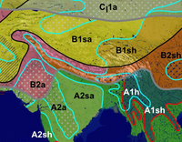
Climate zones are affected by several factors. One very important factor is the orography. Just think of snow-covered mountains in tropical regions. This phenomenon is a consequence of lower temperatures at higher elevations.

The Himalayan region is an area of widely varying orographic features. There are huge mountain ranges with deep, steep valleys, highlands and basins, and a wealth of surface structures in between. This spectacular orography is reflected in the distribution of climate zones.

Print the PDF-file.

And answer the following questions by drawing in the main wind directions for the Summer and Winter Monsoon. Use the climate and precipitation map provided and/or other useful material as a basis for the drawing.

Which is the main wind direction based on the distribution of humidity?

Which mountain range is responsible for the regions of tropical winter rain?

Why are the driest areas located to the North and North-West of the Himalayan mountain range?

Compare the orography, the location of the climate zones and the distribution of the population and explain the relationship between them.


Acrobat Reader is required to view and print the PDF. Download Adobe Acrobat free of charge.
 
 
Meteosat-5 image taken on 15 November 2004
   
Meteosat
 
Monsoon
 
The South-Western Summer Monsoon is the most influential weather phenomenon in Asia's tropical and subtropical regions. It brings both essential rain and dangerous floods.

The Monsoon has already travelled a very long way before it reaches the Asian subcontinent. The aim of this exercise is to follow the Summer Monsoon along its whole route, so as to understand the different influences involved.

Use the information provided in the Background section, as well as climate and topographic maps to complete the exercise.
  • Print the Meteosat-5 image of 15 November 2004.
  • Draw the equator, the Southern and the Northern Tropic onto the image.
  • Draw the ITC for June onto the image.
  • Draw the route of the South-East Trade winds and the resulting South-West Monsoon onto the image.
  • Mark the areas with high, medium and low rainfall within the Asian subcontinent (e.g. use different textures).
Now answer the following questions:

How does the intertropical convergence zone (ITC) affect the Summer Monsoon?

Where do the South-Eastern air streams change their direction?

Which force redirects the air streams?

In which direction does this power redirect air streams in the Northern, and in which direction in the Southern hemisphere?

Explain the reasons for areas with high, medium, and low rainfall within the Indian subcontinent during the Summer Monsoon.


Page12


Last update: 17 April 2013


Himalaya

 •  Introduction (http://www.esa.int/SPECIALS/Eduspace_Weather_EN/SEMLWXJTYRF_0.html)
 •  Background (http://www.esa.int/SPECIALS/Eduspace_Weather_EN/SEM7XXJTYRF_0.html)

Exercises

 •  Introduction (http://www.esa.int/SPECIALS/Eduspace_Weather_EN/SEMZYXJTYRF_0.html)
 •  Study of water vapour in the atmosphere (http://www.esa.int/SPECIALS/Eduspace_Weather_EN/SEMY9ZJTYRF_0.html)
 •  The summer monsoon and its floods (http://www.esa.int/SPECIALS/Eduspace_Weather_EN/SEM9EZJTYRF_0.html)

Links

 •  Meteosat images (http://www.eumetsat.int)
 •  Weather broadcast worldwide (http://weather.edition.cnn.com/weather/intl/forecast.jsp)
 •  Climate system (http://www.espere.net/index.html)
 •  CARE (http://www.careinternational.org.uk/)
 •  DLR - Basemapping
of Dhaka
(http://www.zki.caf.dlr.de/applications/2004/bangladesh/bangladesh_flood_2004_en.html)

Eduspace - Software

 •  LEOWorks 3 (http://esamultimedia.esa.int/multimedia/LEOWorks3.exe)
 •  ArcExplorer (http://esamultimedia.esa.int/multimedia/eduspace/ae2setup.zip)

Eduspace - Download

 •  Climate zones (PDF) (http://esamultimedia.esa.int/docs/eduspace/climatezones.pdf)
 •  Climate diagrams (PDF) (http://esamultimedia.esa.int/docs/eduspace/Diagramm.pdf)
 •  Temperature and precipitation diagrams (PDF) (http://esamultimedia.esa.int/docs/eduspace/himalaya_climate_temperature.pdf)
 •  Ready-made diagrams (PDF) (http://esamultimedia.esa.int/docs/eduspace/Diagramm_fill.pdf)
 •  Himalayas water vapour images (ZIP) (http://esamultimedia.esa.int/docs/eduspace/MERIS_WV_2003.zip)
 •  SPOT XS images of Bangladesh (ZIP) (http://esamultimedia.esa.int/docs/eduspace/flood88.zip)
 •  Landsat images of Bangladesh (ZIP) (http://esamultimedia.esa.int/docs/eduspace/ganges1989_2000.zip)
 •  Shape files for Bangladesh (ZIP) (http://esamultimedia.esa.int/docs/eduspace/shapes_bangladesh.zip)
 •  Map of climate zones (http://www.esa.int/images/climatemap,0.jpg)