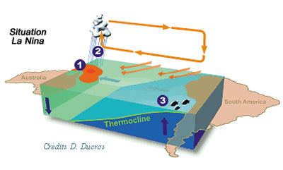
Exercise 4: La Niña


La Niña


La Niña is characterised by colder than usual ocean temperatures in the Equatorial Pacific. It is caused by strong trade winds that make the warm pool shrink and cool the Tropical Pacific. The climate is drier and colder off the coast of both North and South America. The upwelling of cold water is stronger, and the phytoplankton concentration grows. The La Niña phenomenon usually takes places in the months following an El Niño event, and is part of the ENSO process.
 
Atmospheric convection is confined to the Western end of the basin. Rain is abundant over Indonesia.

We can also observe the effect of La Niña on sea level and surface temperatures. They are the opposite of the El Niño year. Usually SST anomalies show a more visible pattern than altimetry anomalies.
 
 
LEOWorks exercise
 
It is possible to make some animations with the series of data we have.

Open the data files from 2007-2008. Compose animations with the altimetry and SST data for this period and study them.

In the LEOWorks image processing programme open Tools/Image Animation, which brings up the Select Files for Animation window. Choose the proper animation speed. You can see the number of the slide by activating the Active Slider.


1. Can you explain what effect La Niña has over the mean sea level and SST?

2. What are the differences with respect to El Niño?


Last update: 17 April 2013


El Niño

 •  Introduction (http://www.esa.int/SPECIALS/Eduspace_Weather_EN/SEML1PVO1FG_0.html)
 •  Background (http://www.esa.int/SPECIALS/Eduspace_Weather_EN/SEMN3PVO1FG_0.html)

Exercises

 •  Exercise 1: Sea Level Height (http://www.esa.int/SPECIALS/Eduspace_Weather_EN/SEMG5PVO1FG_0.html)
 •  Exercise 2: Sea Surface Temperature (http://www.esa.int/SPECIALS/Eduspace_Weather_EN/SEMMCPVO1FG_0.html)
 •  Exercise 3: Ocean Colour (http://www.esa.int/SPECIALS/Eduspace_Weather_EN/SEMRJPVO1FG_0.html)

Eduspace - Software

 •  LEOWorks 3 (http://esamultimedia.esa.int/multimedia/LEOWorks3.exe)

Eduspace - Download

 •  Altimetry (2007-2008) (zip) (http://download.esa.int/images/EduSpace/LaNina_2007-2008_Altimetry.zip)
 •  SST (2007-2008) (zip) (http://download.esa.int/images/EduSpace/LaNina_2007-2008_SST.zip)

Related links

 •  Ocean Surface Topography from Space (http://sealevel.jpl.nasa.gov/)
 •  GHRSST (http://www.ghrsst.org/)
 •  AVISO - ENSO maps (http://bulletin.aviso.oceanobs.com/html/produits/indic/enso/welcome_uk.php3)