ESAEducationAccueilMétéo et climatChangement globalLes catatastrophes naturelles
   
Météo
Le FoehnMétéosat InteractifImages de Météosat
Climat
Climat de l’HimalayaClimat, saisons et météorologie en AfriqueEl NiñoJP Explorer - Explorer le monde et son climatLe Gulf StreamLe lac Tchad
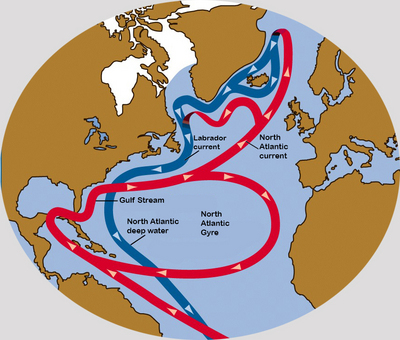


Article Images
Le gyre de l’Atlantique Nord
 
Download:
 HI-RES JPEG (Size: 402 kb)
This illustration shows the main currents of the North Atlantic Gyre, flowing in a clockwise direction. Further north we can also locate the North Atlantic subpolar gyre.
 
 
Download:
 HI-RES JPEG (Size: 476 kb)
In this illustration we can see the warm flow of the North Atlantic Gyre and North Atlantic current, as well as the cold deep backflow heading South, eventually crosseing under the Gulf Stream.


Le Gulf Stream
Introduction
Contexte
Courants de la surface de la mer
Exercices
Exercice 1 : Température de surface de la merExercice 2 : Hauteur de la surface de la merExercice 3 : Les tourbillons
Eduspace - Software
LEOWorks 4 (MacOS)LEOWorks 4 (Linux)LEOWorks 4 (Windows)
Eduspace - Download
GulfStream.zip


   Copyright 2000 - 2015 © European Space Agency. All rights reserved.