|
Meteorologia Vento FoehnMeteosat InteractivoImagens do MeteosatClima Clima AfricanoA Corrente do GolfoEl NiñoClima dos HimalaiasExplora o mundo e o clima com JP ExplorerLago Chade |
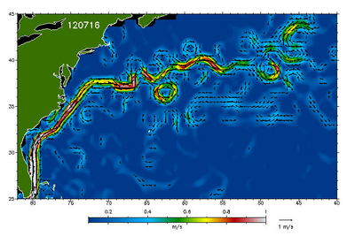
| A Corrente do Golfo IntroduçãoInformação de Base O Giro do Atlântico NorteExercícios Exercício 1: Temperatura da superfície do marExercício 2: Altura da superfície do marExercício 3: TurbilhonamentosEduspace - Software LEOWorks 4 (MacOS)LEOWorks 4 (Linux)LEOWorks 4 (Windows)Eduspace - Download GulfStream.zip | |||||||||||||||||||||||