
Envisat making first direct measurements of ocean surface velocities
For more than a decade space-based radar instruments have been routinely observing ocean surface phenomena including wind, waves, oil slicks, even the eyes of hurricanes. Now – employing the same principle as police speed guns – satellite radar has also begun to enable direct measurements of the speed of the moving ocean surface itself.
The oceans that cover 71% of the Earth’s surface are constantly in motion. Ocean surface currents can lead to strong interaction with wind and waves, and through the transfer of heat influence the weather. Their dynamic range in the mesoscale is broad, with features such as current eddies and fronts, occurrences of filaments and jets, and wind-driven coastal upwelling or downwelling.

High-resolution surface current observations on a large scale are very difficult, although satellite altimeters permit monitoring of sea level anomalies that are related to surface currents. Sea surface temperature and ocean colour measurements also throw light on ocean circulation pattern and seasonal variations.
However Synthetic Aperture Radar (SAR) instruments such as the ASAR on ESA’s Envisat have now been demonstrated to potentially offer a more direct and therefore very valuable source of high-resolution information for oceanographers.
SAR sensors record microwave radar backscatter in order to identify patterns of surface roughness. Indeed, over the ocean these patterns are linked to varying surface winds and currents – in particular current shear and varying convergence zones that can focus wave energy, resulting in increased wave steepening and enhanced radar-detectable roughness changes. Unfortunately, interpreting radar images to accurately identify and quantify such signatures has been easier in theory than in practice.

"Due to a general lack of sufficient high-quality in-situ observations, the understanding of how these dynamic features contribute to the complicated surface roughness modulation pattern often manifested in SAR images is incomplete," explained Johnny Johannessen of the Nansen Environmental and Remote Sensing Center (NERSC) in Bergen, Norway, who presented results at ESA’s SeaSAR 2006 workshop.
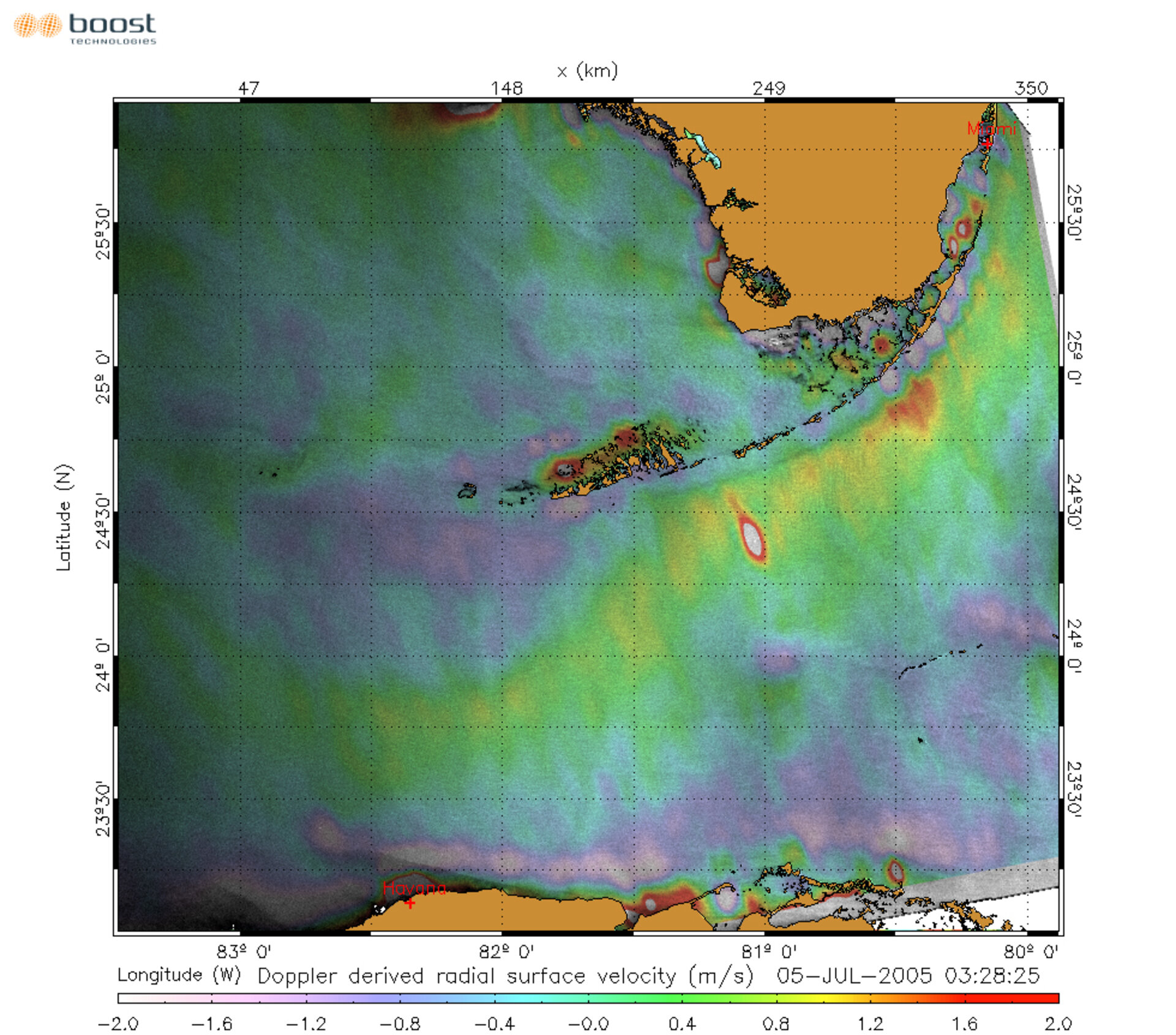
But a new light is being shed on these analyses by using neglected extra information embedded in the radar signal: the Doppler shift in electromagnetic waves reflected from the water surface. This shift occurs due to changing relative velocities, experienced in everyday life in the way the pitch of a siren on a passing ambulance goes up as it approaches, then goes down as the vehicle recedes away. This ‘Doppler Effect’ also serves as the basis of police speed-measuring radar guns.
In this instance, the shift is introduced by the relative motion between the satellite platform, the rotation of the Earth and the velocity of the particular facets of the sea surface from which the SAR signal scatters back to orbit. The initial two values are well known – particularly for Envisat, with its very stable satellite orbit and attitude – and can be simply subtracted to extract the useful sea surface velocity information.

"This surface velocity, in turn, is composed of contributions from the wind-wave induced motion, and the background surface current," Johannessen added. "Following the Doppler shift equation an estimate of the surface current can be obtained, providing the contributions from wave- and wind-induced motion are first quantified and removed. It is here that the Radar Imaging Model (RIM) comes in."
The RIM is a numerical model that combines outputs from specialised high-resolution ocean models with fundamental equations for SAR imaging of ocean current features and simulate appropriate radar cross section signatures. RIM outputs provide both wave- and wind-induced ocean surface motion for subtraction.
"Our ability to interpret and quantify surface current features imaged by SAR has not been adequately developed," Johannessen added. "By applying this combined Doppler and Radar Imaging Model technique – DopRIM for short – things are now looking much more promising."
This new analysis is still limited to surface velocity measurements in the line-of-sight of the radar instrument. But this new source of information already provides a useful complement to the standard roughness pattern analysis.
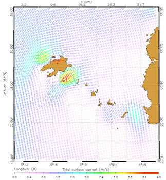
Initial tests have been carried out on tidal currents off Brest and Cherbourg in France, with simulations compared to SAR images of the same sites and tidal surface currents derived from the combined results. Impressive new views of the ocean from radar measurements are now available to open up new scientific investigations and applications.
The results so far were presented at SeaSAR 2006, which took place at ESRIN, ESA’s European Centre for Earth Observation in Frascati, Italy, at the end of January. More than 100 researchers from 20 countries participated in the four-day workshop.
"More evaluations are certainly needed to consolidate and validate this DopRIM method," Johannessen said. "We believe however that the preliminary but promising results will open new opportunities for more systematic studies of mesoscale ocean variability based on SAR in the coming years. Provided the method is found to be reliable it will make a significant contribution to operational oceanography."
These measurements would be very useful for determination of surface drift, important for oil dispersion, wave-current interaction and pollution transport. The method could complement the use of additional information sources, such as 3-D ocean models, atmospheric forcing fields and in-situ devices such as high-frequency radar stations, as well as differing satellite sensors, wavelength and polarisation characteristics.
This includes future experimental SAR satellites, such as TerraSAR-X and Cosmo-Skymed, planned to join the currently operating Envisat, ERS-2, Canada’s Radarsat and Japan’s just-launched Advanced Land Observing Satellite (ALOS). ESA is also planning a series of operational satellites known as Sentinels - designed to support the Global Monitoring for Environment and Security (GMES) initiative of the Agency and the European Union – with one being dedicated to ocean applications.
Envisat ASAR wave data sharpening Meteo France ocean forecasts
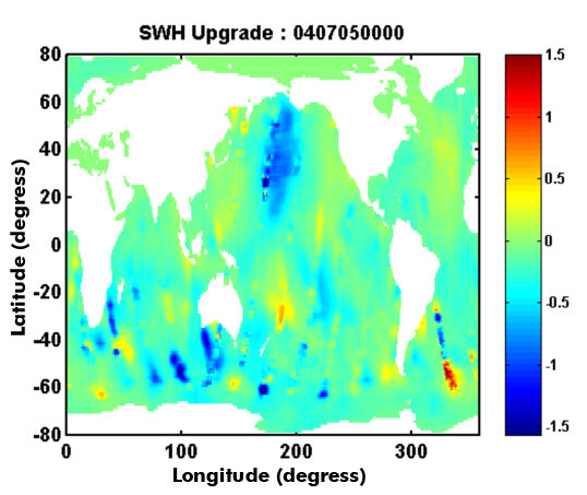
Also presented at SeaSAR 2006 was the latest in an ambitious project to assimilate another Envisat ASAR product – Wave Mode data, which yields wind speed and wave spectra over the open ocean – into the sea state prediction models of French national weather forecaster Meteo France. The forecaster already assimilates altimetry data from Envisat sensor, the Radar Altimeter-2 (RA-2), and has been working on ASAR assimilation since 2003.
"The work is still part of our research and development activities but hopefully we will step forward into operational mode soon," said Lofti Aouf of Meteo France. "The impact of the assimilation of ASAR wave spectra processed with an upgraded algorithm on wave parameters – wave height, period and direction – stays efficient for more than three days into the forecast period, following the end of the assimilation.
"We developed an assimilation system which conjointly uses RA-2 significant wave height and ASAR directional wave height. The results indicated a significant impact on mean wave parameters, results being validated with independent wave data, such as wave height from the French-US Jason-1 satellite altimeter.
"During a one-month test run the results showed a correction of root mean square (RMS) error of 20%, with the impact duration induced by the combined assimilation being further enhanced. This task has important consequences on related research topics such as air-sea interaction processes, including heat fluxes transfers and current circulation."
Harald Johnsen of Norwegian company NORUT IT explained how an upgraded ASAR Wave Mode algorithm had been developed following detailed comparisons of ASAR coverage across the world’s oceans with in-situ data from buoys and platforms, as well as numerical ocean and atmospheric models, to arrive at a database of co-located spectra. The cross-comparison revealed a number of problems and ambiguities in terms of swell estimation which the processing algorithm was then upgraded to remove.
Validation of the results clearly shows an increase in meaningful spectra – as opposed to ‘non-physical spectra’ previously observed – and an improved flagging of ambiguous data, as well as a decreased average deviation between the data and wave forecasting system of the European Centre for Medium-Range Forecasting (ECMWF). Reprocessing of the entire ASAR Wave Mode archive is now being undertaken at the Centre ERS d’Archivage et de Traitement (CERSAT) operated by the French Research Institute for Exploitation of the Sea (IFREMER).
Envisat ASAR wave data analysis over coastal areas
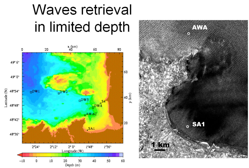
ASAR measurements are also providing a unique ability to estimate the wave climate over coastal areas. The processing of SAR images in general – and Envisat’s ASAR in particular – offers potential for imaging large areas with a high resolution capability to provide fine information about the spatial variations of the wave field.
As presented during SeaSAR, ASAR measurements revealed details of the swell transformation that can be related to the underlying bathymetry and/or coastal currents. Encouraging results have been obtained to produce SAR-derived maps of significant wave heights at a resolution of about 1 km, to be combined with simple ray-tracing models.


