ESA celebrates 15 years of near-real time data delivery in Earth Observation
Decision-makers, scientists and local authorities require up-to-date environmental information in order to manage natural resources, respond to natural disasters and better understand climate change. ESA has been responding to this requirement since 1992 by offering data from Earth-observing satellites in near-real time to allow users to study and monitor the current state of the oceans, lands, atmosphere and cryosphere.
At the end of the commissioning phase of ESA’s ERS-1 satellite in early 1992, the space agency began disseminating oceanographic data of the satellite’s onboard instruments to users through a network of landlines. Many of these data were re-formatted in near-real time for compatibility with end-users connected to the World Meteorological Organisation (WMO) network.
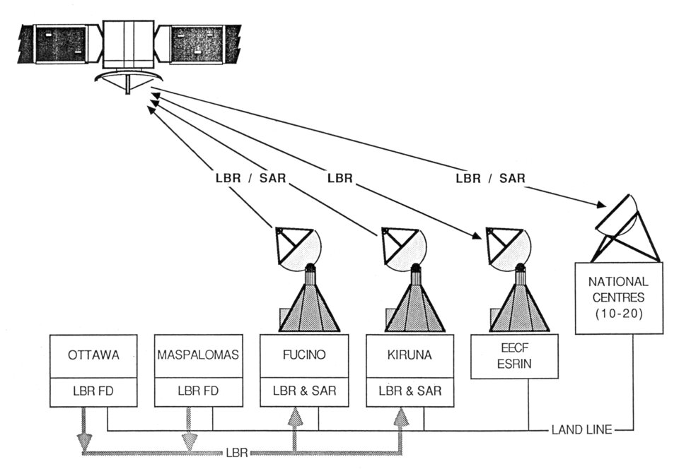
A few months later, ESA implemented an innovative system allowing some users to receive data through small dish antennas. This system, called Broadband Data Dissemination Network (BDDN), was based on telecommunication satellites broadcast. During this period, only data of small volume were delivered in near-real time (i.e. within three hours), while data of larger volumes took nearly 24 hours to be delivered.
As the need for timely information increased for environmental forecasting and disaster response, ESA sought to speed up its data flow by making use of emerging technologies. By the time ESA launched ERS-2 in 1995, the space agency was readily using the Internet to deliver data from more sophisticated instruments, such as the Global Ozone Monitoring Experiment (GOME).
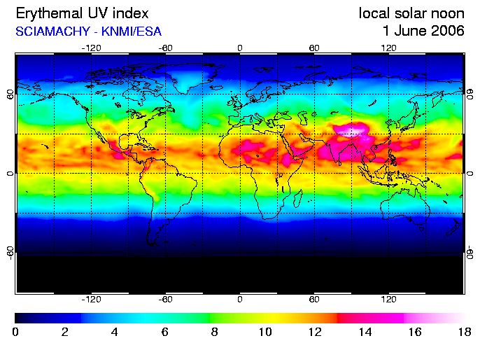
Responding to the growing demand for ozone data to monitor the ozone layer and improve ultraviolet (UV) radiation forecasts, ESA began using the GOME instrument aboard ERS-2 to maintain a regular census of global stratospheric ozone levels. Since 1997, the sensor has been delivering near-real time data on ozone levels to users. It also provides coverage of other trace gases, UV and air-pollution monitoring.
The need for near-real time data delivery has continued to increase over the last 10 years as a consequence of the incredible progress in Information Technology; the power of computers and the growth in network bandwidths and storage capacities have resulted in Earth observation (EO) users requesting larger volumes of data to be delivered in unprecedented time frames.
In an effort to meet these demands and deal with the vast amount of near-real time data produced by Envisat, the world’s largest Earth-observing satellite launched by ESA in 2002, ESA upgraded its data delivery method to the quicker Data Dissemination System (DDS), which also uses telecommunication satellites. In addition, as the ESA mandate for delivering EO data expanded to non-ESA missions (Third Party Missions), the various European centres delivering EO data were interconnected through large communication networks.
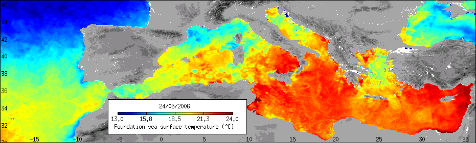
Fifteen years later, there are many established services requesting near-real time EO data delivery. For example, utilising data from Envisat’s Advanced Along Track Scanning Radiometer (AATSR) instrument, as well as other instruments aboard different satellites, daily sea surface temperature maps of European seas are made available as part of the agency’s Medspiration project.
Today’s Earth check-up provides access to daily worldwide fire maps, UV radiation levels, ozone forecasts and daily sea surface temperatures.
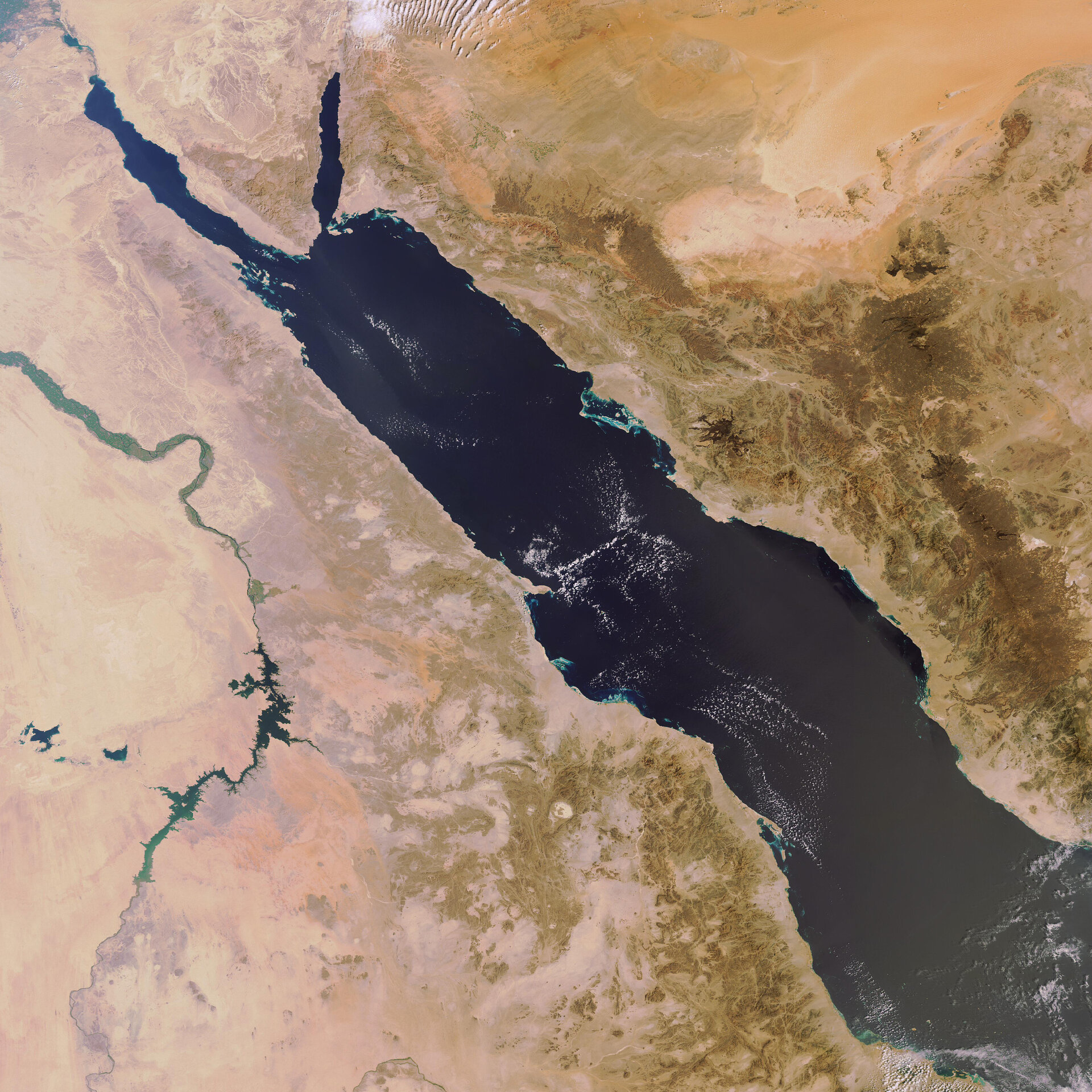
The latest ESA near-real time capability added to the Earth check-up is MIRAVI, short for MERIS Images RApid Visualisation. MIRAVI, which debuted last December, allows people unfamiliar with EO data to track natural events in progress, such as fires, floods and volcanic eruptions, or simply explore the planet through the eyes of a satellite. Although the MIRAVI images are fascinating and provide the marvellous feeling that users are ‘onboard the satellite’, scientists prefer to use the complete MERIS products, which are also available through near-real time servers, for research purposes.
Just as ESA has met the growing number of users and requests for data from a few gigabytes transmitted per day in 1992 to 400 gigabytes delivered daily in 2007, it will continue to develop and exploit new technologies to meet the rising demands of near-real time Earth data from space.
In the next months, ESA will further expand its range of EO data available in near-real time to scientists by allowing them easy access to large amounts of Synthetic Aperture Radar (SAR) and MERIS data, particularly over Europe.