
Earth from Space: ‘Sea of the Viennese’
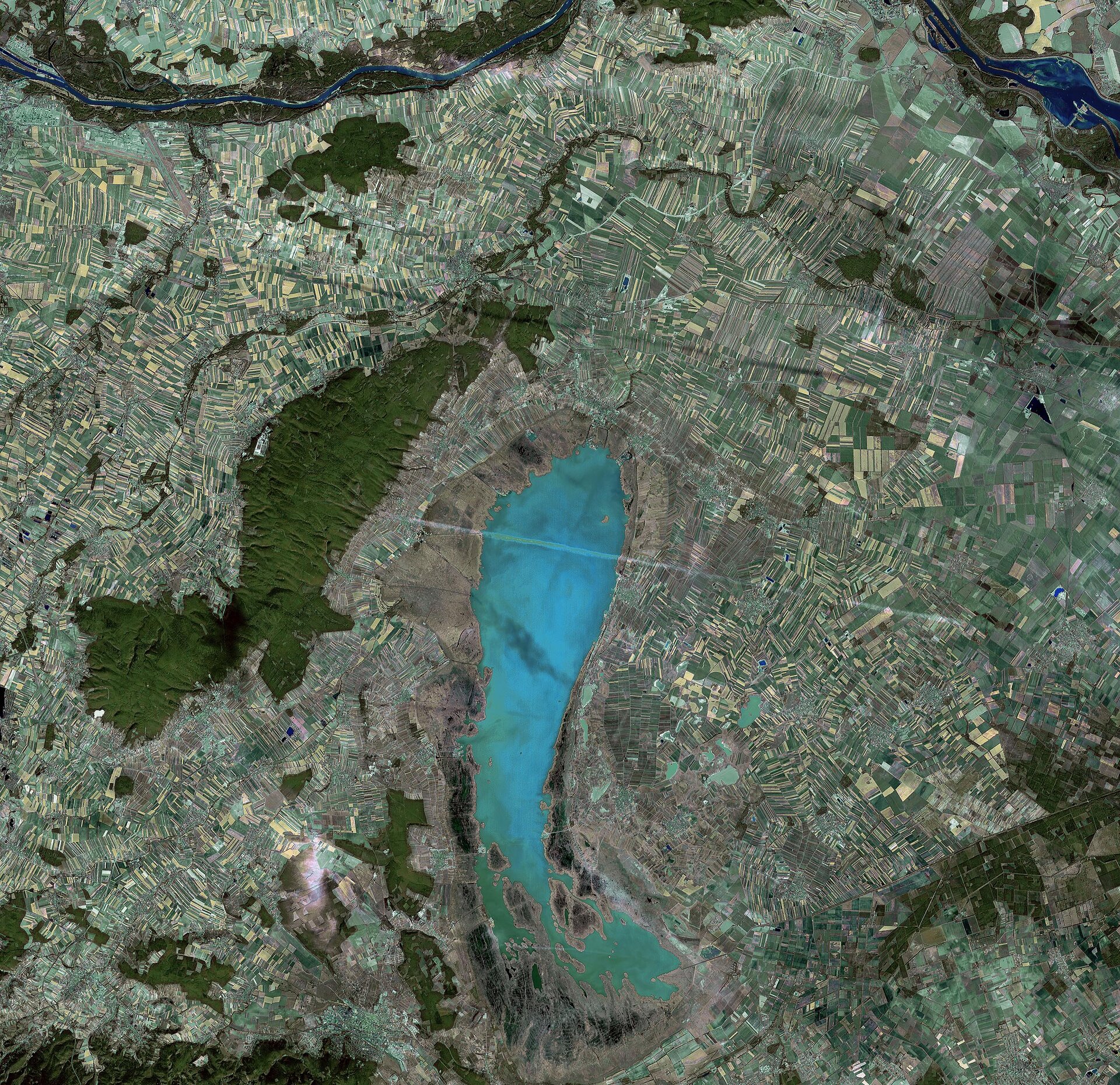
Lake Neusiedl, straddling the Austrian–Hungarian border, is featured in this satellite image. The largest steppe lake in Central Europe, Neusiedl covers an area around 315 sq km, with 240 sq km situated in Austria and 75 sq km in Hungary (bottom).
Reeds, ponds and wetland areas that provide important habitat for fauna and flora as well as for migratory birds surround Lake Neusiedl, which is a protected wildlife sanctuary.
In addition to the natural landscape and extraordinary wildlife, this is a highly developed area with more than 1500 landowners whose patches of land are now an integrated part of the protected area.
Lake Neusiedl, called the 'Sea of the Viennese' due to its close proximity to Vienna, has totally dried up at least 100 times since it formed around 16 000 BC. Since the lake provides humidity and temperature buffering, the drying-up of the seabed causes major environmental disruptions. The Austro-Hungarian Water Commission has been controlling the water level via a dam since 1956.
The unique landscape of the Lake Neusiedl region, which encompasses an area of around 747 sq km around the lake, was designated a UNESCO World Heritage Site in 2001.
The Leitha Mountain range, called 'Leithaberg' by locals, is visible in green northwest of the lake. The soils of the mountains, which are covered by dense deciduous woodland, are dominated by slate and marine limestone.
The Seewinkel area, the largest inland salt region in Austria and one of the most important in Europe, is located east of the lake. As visible, this area is characterised by numerous saline alkaline lakes scattered among grazed meadows.
The sunny climate of the area, the soil and the lake’s ability to moderate extreme climate provide optimal conditions for the wine industry; today, wineries are located all around the region.
The famous Danube River, one of Europe's main traffic arteries, is visible running across the top of the image. The Danube has its source in Germany's Black Forest and flows through nine European countries for a distance of about 2850 km.
An aircraft condensation trail, or 'contrail', is visible in white stretching across the image centre. A shadow of the contrail is visible along the top of the image.
SPOT-4 acquired this image on 9 October 2006 with a spatial resolution of 20 m. SPOT-4 is supported by ESA as a 'Third Party Mission', which means ESA utilises its multi-mission European ground infrastructure and expertise to acquire, process and distribute data from the satellite to its wide user community. The SPOT system was designed by the French space agency (CNES) and is operated by Spot Image.


