Figure 1

When it was decided in 1990 to build ERS-2, the prime motivation was to provide a follow-on to ERS-1 and thereby ensure the necessary continuity of data and services to both the scientific research and operational application user communities. When it became clear towards the end of 1993 that ERS-1 would remain technically operational well beyond its 30-month design lifetime, strong interest was expressed, at several ERS-1 User Meetings and Symposia, in the simultaneous operation of ERS-1 and ERS-2 over a period of several months, and possibly up to one year.
To explore the potential benefit that would result from such ERS-1/2 tandem operations in more detail, several consultation meetings with both scientific and application-oriented users were organised by the Agency. They showed that a great many advantages and benefits for both research and applications would accrue from flying two identical sets of instruments in an appropriate orbital configuration; in particular, a 'unique SAR data set' could be collected for interferometry applications.
On 23 March 1995, the ESA Council adopted a Resolution on ERS-1/ERS-2 tandem operations which will 'keep ERS-1 alive' until April 1997 and allow such operations for a nominal duration of nine months, beginning at the end of the ERS-2 Commissioning Phase in autumn 1995.
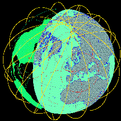
ERS-1 and ERS-2 are flying in the same orbital plane with an inclination of about 98.5 degrees to the Earth's equatorial plane, giving the satellites visibility of all areas of the Earth as it rotates beneath them (Fig. 1). Each satellite's pattern of orbital tracks over the Earth's surface repeats itself exactly after a certain number of days. This 'repeat cycle' depends upon the altitude of the orbit; ERS-1 and ERS-2 are both flying at the same mean altitude of 785 km, providing a repeat cycle of 35 days.
The passes of the two satellites over the ground receiving stations last about 10 min. The reconfiguration of the stations between the end of one satellite's pass and the beginning of the pass of the next takes about 15 min; since the orbital period is approximately 100 min, the time interval between the two satellites has to be between 25 and 75 min. With the current orbital configuration, ERS-2 follows ERS-1 with an approximate delay (called the orbit phasing of the two satellites) of 35 min.
Because of this delay and the Earth's rotation, the ground-track patterns of ERS-2 are shifted westwards with respect to those of ERS-1 (Fig. 2). The orbit phasing has been adjusted to ensure that ERS-2's track over the Earth's surface coincides exactly with that of ERS-1 24 h earlier. Within the repeat cycle of 35 days, the opportunity to observe any point on the ground under identical conditions (altitude, incidence angle, etc.) is therefore doubled during the tandem operations. Different ground-site revisiting intervals can be achieved by changing the orbital phasing of the two satellites.
The ERS-1/ERS-2 tandem mission is being operated with a very limited additional budget and with a ground-segment infrastructure that was designed for just a single satellite. It is therefore only feasible at all subject to the following assumptions:
The current orbit phasing of 1 day, needed to calibrate the ERS-2 Radar Altimeter during the Commissioning Phase, will be retained until the end of 1995, when orbit manoeuvres will take place to introduce an 8-day ground-site revisiting cycle, which is an attractive alternative for many scientific and application-oriented users.
Figure 1

Figure 2
Consequently, data acquired jointly by ERS-1 and ERS-2 will undoubtedly give rise to numerous demonstration projects and new scientific research in many fields of earth sciences (e.g. agriculture, hydrology, and emerging applications such as SAR interferometry), and will be exploited in particular in a large proportion of the proposals selected from the recent ERS Announcement of Opportunity.
The SAR interferometry technique, which in the past was an airborne technique, has shown its true potential with ERS-1. This technique requires several satellite passes over the same area in order to obtain a suitable pair of images, with the orbital cross-track separation constituting the interferometer baseline (Fig. 4). For each pixel corresponding to the same area of ground in both images, the phase values (depending on the satellite to ground pixel path length) are subtracted to produce a phase-difference image known as an 'interferogram'. Knowing the orbit parameters, the phase interferogram can be used to generate a Digital Elevation Model (DEM) of the surface, with an accuracy in the order of 10 m. An additional product is the so-called 'coherence image', which shows bright areas where the coherence between the two SAR images is high, indicating no variation in backscatter between the acquisition times of the two images. Dark regions indicate areas where changes have occurred.
Satellite SAR interferometry is a very powerful tool for generating DEMs with medium accuracy, very efficiently and for a large fraction of the land surface. For cloudy areas or for regions with extremely low textural surface features, it is the only method that is feasible.
The large-scale generation of DEMs depends on the tandem mission for its success, as several constraints have to be met which cannot always be satisfied with just one SAR in operation; namely
Investigations have shown that for some regions correlation degrades by as much as 10%in 5 days.
DEMs are one of the most useful auxiliary remote-sensing data sets. They provide the ability to correct images of the Earth - from both microwave and optical sensors - for offsets caused by elevation differences, as well as facilitating adequate geo-referencing of these data.
DEMs are also an important tool in many earth-sciences disciplines, greatly improving flood forecasting through modelling of the watershed hydraulics, and helping to determine water availability for irrigation, power production, industrial and agricultural production, from local slope information. In glaciology, they have already demonstrated their potential for determining topography over ice sheets and glaciers and deriving ice motions. Combined with spatial-analysis models, they can be used to identify and simulate viewing perspectives for land-use planning. DEMs are also useful for military applications, and there is already a significant market for commercial applications, such as mobile communications where they are an essential tool in the implementation of ground relays.
Figure 5 shows the current availability of topographic data. Extensions of the present DEM coverage will be extremely difficult with conventional methods, because most of the globe's still unsurveyed land areas are in the predominantly cloud-covered and humid tropical regions and in the polar areas.
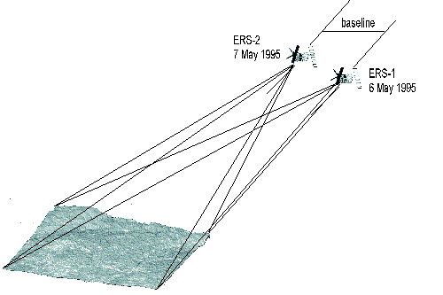
Figure 4

Figure 5. Source: NASA Topographic Science Working Group Report
Just a few days after the launch of ERS-2, a number of SAR images were made using ERS-1 and ERS-2 in tandem mode, observing the same region with a one-day interval. These data were quickly processed and analysed by European experts to demonstrate some of the possibilities offered by SAR interferometry for the generation of DEMs.
First example over Central Italy: generation of a radar interferogram as a basis for a three-dimensional map of the Earth's surface
An interferogram uses not the brightness (intensity) of the reflected radar beam, but the phase information it contains. The phase differences that occur for two slightly shifted viewing angles are calculated individually for each pixel, by analysing images recorded from slightly offset positions during overpasses of ERS-1 and ERS-2 on consecutive days. As these phase differences are directly related to the heights of the terrain being surveyed, when colour-coded they resemble the contour lines of a topographical map.
The tandem-interferogram in Figure 6 shows a 15 km x 20 km section from the first ERS-2 SAR image of 2 May 1995, combined with an ERS-1 image from the previous day. In this case, the orbits of the two satellites were about 400 m apart (the optimum figure is rather less). The individual interference zones (colour cycles) correspond in each case to a difference in height of around 22 m. The image processing was performed by Prof. Rocca's team at the Politecnico di Milano (Italy).
The interference patterns are seen most clearly in the mountainous regions; here blurred areas point to the existence of forested areas which, because of the height of the trees, are seen differently from the different viewing angles of the two satellites (this is known as the volumetric effect ). On the other hand, there is pronounced blurring in the sea area and in parts of the enclosed lowlands, because the coherence requirement is barely met over the water. Comparison with a multi-temporal image (Fig. 7) combining the ERS-1 and ERS-2 data used in generating the interferogram provides an idea of the effect that the varying wind fields (and consequent wave patterns) and changes in soil moisture or surface coarseness can have on coherence.
Second example over the Maastricht area of the Netherlands: generation of a radar interferogram and DEM
On 7 May 1995, ERS-2's SAR imaged the area known as three-countries corner , where the borders of Belgium, Germany and the Netherlands meet. As Figure 8 shows, one can easily make out the valley of the River Meuse running vertically up the picture, with Liege (B) at the bottom edge and Maastricht (NL) closer to the centre. To the right of Maastricht is Aachen (D), appearing as a light-toned patch with the fringes of the Ardennes below it in a lighter grey. Eindhoven (NL) is visible at the left-hand edge of the picture.
Whilst a single image like this will yield detailed information about, for example, forested areas or other types of ground use, a great deal of examination and comparison with observations made on the ground is needed. By superimposing several images, however, particular features become apparent much more quickly and this opens up other potential applications also.
To demonstrate this, the ERS-2 SAR image of 7 May 1995 has been combined with an ERS-1 image that was recorded the previous day (Fig. 9). The resulting interferogram (Fig. 10) shows the typical striped patterns created by such superpositioning. These patterns contain information about the differences in distance of the individual pixels at the various positions from which the two satellites recorded the images (the distance between the two recording positions - the baseline for the digital triangulation - for this image-pair was approximately 220 m) and are like the contour lines on a topographical map. The difference between the chain of hills in the Ardennes to the bottom right and the very much flatter terrain elsewhere in the picture is immediately apparent.
Figure 11 shows - just like a multi-temporal image - where the phases differ and where they match (providing a measure of the differences in distance at the recording positions at a given moment) for the two satellite overpasses. Light-grey tones show a high degree of coincidence (i.e. little change), while dark areas point to changes of all kinds. So, for example, the wooded areas now appear more distinctly than they did in the single images as dark areas in which volumetric effects (brought about by differing views of the trees due to the slightly offset viewing points of the two satellites) make the phases of the reflected signals differ from one another. More detailed analysis is needed for the three light zones to the left of centre, which show up very differently in the individual images.
Figure 12 offers a quasi-three-dimensional view (looking from the northwest) of the lower right-hand part of Figures 8 and 9. The data on which this is based are firstly the raw version of a digital height model produced from the tandem interferogram (Fig. 10), and secondly the intensity values from the ERS-2 overpass, which give this height model the appearance of a landscape. The greatly exaggerated relief shows the fringes of the Ardennes together with the chain of hills in front of them leading to the Meuse valley visible on the right of the picture. This demonstrates how, during the ERS-1/ERS-2 tandem mission, the sets of data from the two satellites can be combined to provide digital height models.
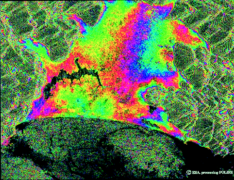
Figure 6

Figure 7

Figure 8. ERS-2/ERS-1 SAR images processed by CNES (Copyright ESA/CNES 1995
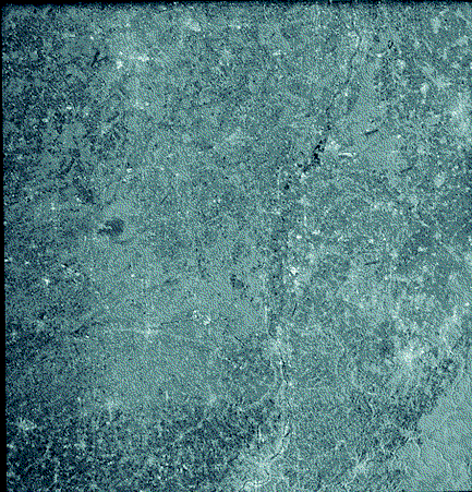
Figure 9. ERS-2/ERS-1 SAR images processed by CNES (Copyright ESA/CNES 1995)

Figure 10. ERS-2/ERS-1 INSAR images processed by CNES (Copyright ESA/CNES 1995)
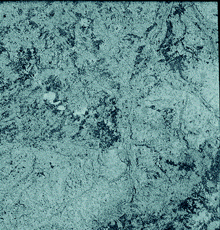
Figure 11. ERS-2/ERS-1 INSAR images processed by CNES (Copyright ESA/CNES 1995)
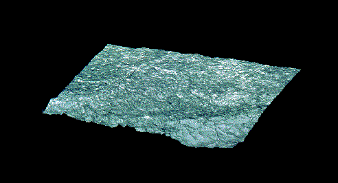
Figure 12. Map-corrected digital height model from ISTAR based on an INSAR image produced by CNES (Copyright ESA/ISTAR/CNES 1995)
The tandem operation of ERS-1 and ERS-2 is providing a unique opportunity to achieve significant advances in both the earth-sciences and applications domains for the next decade. In particular, the use of SAR interferometry techniques should allow the generation of consistent and homogeneous medium-resolution Digital Elevation Models over large portions of the Earth's land and ice masses. Used in a differential interferometry mode, the SAR tandem data sets will also offer a unique opportunity to detect and measure very small - of the order of a few centimetres - topographic changes such as those caused by earthquakes, landslides, volcanic activities and glacier motions.
It is ESA's intention to encourage both the scientific and application user communities to take maximum advantage of this unique tandem data set, thereby opening new perspectives for both scientific research and operational applications in the earth-observation sphere.
The authors wish to thank those experts who have generated these early tandem results and contributed to their analysis and interpretation, namely: G. Solaas, G. Pacheco (ESRIN) and F. Rocca (Politecnico di Milano) for Figure 6, R. Biasutti (Eurimage) for Figure 7, H.Laur (ESRIN), and D. Massonnet (CNES) and F. Perlant (ISTAR) for Figures 10, 11 and 12.


 ESA Bulletin Nr. 83.