
Figure 1. The first flight model of the operational series of Meteosat satellites, MOP-1

Introduction Earth observation from space has clearly demonstrated its growing scientific, social, economic and political importance in recent years by contributing to regular monitoring and hence a better understanding of the Earth and its environment, by supporting a wide range of applications, and by providing essential data for geopolitical purposes. Over the past 25 years, Europe has achieved a high level of expertise and experience in this sector, both at a national and on a cooperative European level. Within ESA, the development and operation of the Meteosat series of satellites (Fig. 1), followed by ERS-1 and ERS-2 (Fig. 2), are well-recognised examples of those achievements (Fig. 3 - Fig. 5).
Figure 1. The first flight model of the operational series of
Meteosat satellites, MOP-1
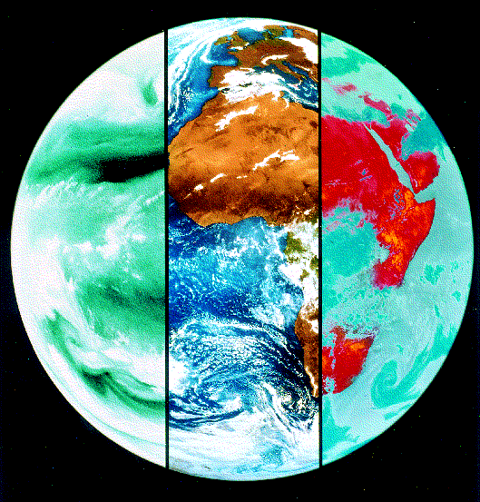
Figure 2. The Earth as seen (left to right) by Meteosat's water-vapour,
visible and infrared channels

Figure 3. The ERS-2 spacecraft being readied for launch in
Kourou, French Guiana

Figure 4. ERS-1/2 SAR multitemporal image of a 96 x 96 square kilometers area
around Gulf of Gaeta (Italy)
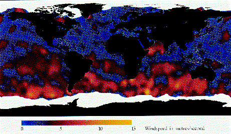
Figure 5. Global wind speeds derived from ERS Scatterometer data.
The ice edges were added using the satellite's Radar Altimeter
data
Earth observation is also evolving rapidly, with a growing community of users from different sectors - public and private, and research as well as applications oriented - with increasingly varied and often incompatible requirements. Against this background of market growth, and in view of the increasing strategic importance of Earth observation from space, there is more than ever a need for a coordinated approach between the European players. Consequently, the Agency, in close cooperation with the European Commission, Eumetsat and the Member States, has developed a proposal for a European Policy for 'Earth Observation from Space' for the next 25 years.
Within this policy framework, the Agency has developed a strategy for its post-2000 Earth-observation activities (beyond Envisat which is currently under development), known as the 'Dual Mission Strategy'. It involves two specific types of missions, known as 'Earth Explorer' and 'Earth Watch' Missions, in order to best address both the existing and anticipated requirements of the scientific and operational applications users.
Both the policy proposal and the Agency's Dual Mission Strategy were well-received by Ministers at the ESA Council Meeting at Ministerial Level in Toulouse last October, and the Agency is now in the process of elaborating concrete proposals for its implementation.
Earth observation from space has the unique advantage of providing continuous global coverage with the temporal and spatial resolutions required by the scientific and operational applications user communities for improving our understanding, monitoring, prediction and management of the Earth's environment and resources.
In taking account of evolving research as well as applications (operational and commercial) interests, the four fundamental objectives that underlie the Agency's present Earth-Observation Programme need to be complemented by a fifth objective reflecting the growing importance of Earth observation for applications users. These objectives are directed towards:
As far as Earth-observation research in the post-2000 era is concerned, the Agency's Earth-observation programme must take full account of the worldwide scientific and public concern related to the environment, climate change and Earth resources. It must therefore duly consider the associated scientific data requirements which span climatology and atmospheric dynamics, atmospheric chemistry and climate change, geodesy and geophysics, ocean, ice and land surfaces. It is also important to consider the interactions spanning conventional disciplines, such as atmosphere/ ocean or land/ocean interactions.
Beyond the research aspects, it is becoming increasingly important to address operational Earth-observation applications, spanning well-established and demonstrated domains like operational meteorology, crop forecasting, land use and cartography, as well as emerging areas like the monitoring of coastal zones. Furthermore, there are a variety of other groups of operational/commercial users with wide-spread but less well developed/formulated needs. It is clear, however, that there are many areas of high economic importance which will benefit in the long term from these Earth-observation data.
The Agency will therefore be aiming on the one hand at increasing user awareness and preparedness, which in most cases takes many years to come to maturity, and on the other at ensuring the provision from space of Earth-observation data that match the current and anticipated needs of the various operational user communities in terms of accuracy, spatial and temporal sampling, and timeliness and continuity of delivery. These needs must be identified carefully through close consultation with the user communities at all levels.
In order to achieve the above objectives, and in line with the proposed European Policy for Earth Observation from Space, ESA intends to depart from the multi-objective programme approach leading to large satellites, and to follow a 'Dual Mission Strategy' more suited to the needs of both scientific and operational users. This strategy comprises:
The Earth Explorer Missions will be entirely funded by ESA and will have mission durations tailored to the specific mission requirements. They will include the possibility of providing instruments through Announcements of Opportunity and with separate funding.
Beyond the development/pre-operational phase to be funded by ESA together with users and/or operational entities, the responsibility for this type of mission will be transferred to (European) entities providing operational services. The timing of this transfer will depend on the maturity of the user community involved and the related status of the operational entity. Data continuity over a period of about ten years will be required to ensure the success of such a scenario.
The two categories of missions will cross-fertilise each other in so far as Earth Explorers could demonstrate new technologies which could be used later on for routine operational applications, whilst Earth Watch missions could provide data that also support scientific activities, e.g. long-term monitoring of specific processes or parameters.
To provide the stability and continuity needed by the users, the Earth Explorer missions are to be implemented through a specific framework programme, the Earth Explorer Programme, in which the selection of the individual missions is to be based on the research needs and priorities of the scientific user community. This will allow scientific criteria to be separated from technological and industrial criteria.
The Earth Watch missions will be implemented as optional programmes in successive phases. They will be carried out in association with partners who will ultimately assume long-term responsibility for these missions and will involve close cooperation with the European Commission. Earth Watch will imply a series of satellites launched at regular intervals to meet operational requirements.
Reflecting this strategy, the future ground segment will follow different approaches for the Earth Explorer and Earth Watch missions and will evolve towards a homogeneous framework of decentralised facilities. This evolution will take due account of both present and forthcoming investments, both at national and European level.
Users of Earth-observation data and information span the spectrum from individual scientists and research institutes through operational entities to commercial companies. In order to inform users about and prepare them for new Earth-observation services, as well as to ease and speed up the transition from the research and development stage to the pre-operational stage in terms of data usage, it is essential that ESA plans appropriate promotional and support activities focussed in three main directions:
Earth observation from space is by its very nature global and goes beyond national limits and continental boundaries. Therefore, international coordination needs to be considered at two different levels, namely the European level and the worldwide scene.
Within Europe, the close coordination between the ESA Earth Observation Programme and the national programmes of Member States to harmonise both missions and data usage with a view to maximising synergy and complementarity will be pursued and enhanced. In addition, ESA will strengthen its cooperation in Earth observation with European entities such as Eumetsat, the European Commission and the European Environment Agency (EEA).
On the worldwide scene, the Agency intends to pursue and strengthen its relations with, in particular, the USA, Japan, Russia, Central and Eastern Europe, China and India. Due account will be taken of the needs of Developing Countries.
ESA will continue to play a major role in international forums such as the Committee on Earth Observation Satellites (CEOS) and will take due account of initiatives such as the International Geosphere-Biosphere Programme (IGBP), the World Climate Research Programme (WCRP) and the Global Ocean Observing System (GOOS).
Following the successful outcome of the Toulouse Ministerial Council Meeting, ESA is now preparing detailed proposals for the Earth Explorer Programme and the first Earth Watch mission for decision by its Member States in the 1997/1998 time frame. The identification, study and assessment of the corresponding mission candidates is well underway.
An initial list of nine potential candidates for the first Earth Explorer mission has been identified in close consultation with the scientific user community, in particular through the User Consultation Meeting held at ESTEC in Noordwijk in October 1994 (Table 1). These candidates are presently being studied and assessed by eminent European scientists, with the support of ESA staff, with respect to their scientific justification, research objectives, observation requirements, and their corresponding mission elements, system concept and programmatics. This assessment will be presented to the user community at a workshop to be held on 29-31 May 1996 in Spain. Its outcome will form the basis for a selection in the second half of 1996 of three or four missions for Phase-A study.
Earth Radiation Mission - to advance understanding of the Earth's radiation balance, which is of fundamental importance to the Earth's climate.
Precipitation Mission - to observe precipitation especially in tropical regions.
Atmospheric Dynamics Mission - to observe three-dimensional wind fields in clear air in both the troposphere and stratosphere.
Atmospheric Profiling Mission - to observe temperature profiles in the troposphere and stratosphere for climate research.
Atmospheric Chemistry Mission - to advance understanding of the chemistry of the atmosphere, including the study of active chlorine species and the hydrogen oxides.
Gravity Field and Ocean Circulation Mission - to derive a highly accurate global and regional model of the Earth's gravity field and its geoid.
Magnetometry Mission - to observe the Earth's magnetic field.
Surface Processes and Interactions Mission - to advance understanding of biospheric processes and their interactions with the other processes that occur in the Earth/atmosphere system.
Topographic Mission - to observe the topography of the oceans, the land and the polar ice sheets.
Concerning applications, two Earth Watch-type missions are currently in preparation by ESA, namely Meteosat Second Generation (MSG), the successor to the current Meteosat geostationary satellites, and METOP, a series of polar-orbiting operational meteorological satellites. Both are being undertaken in cooperation with Eumetsat, which will ultimately assume responsibility for both missions.
Beyond these missions, five other groups of potential Earth Watch communities have been identified by the users (Table 2). These fields are presently under study with respect to their economic importance, the related user communities, the corresponding maturity of usage of Earth-observation data and information, and the potential macro-economic impact of Earth observation. Selection of the most promising area(s) for further, more detailed study is envisaged in the second half of 1996.
Coastal Zones - this covers a wide field of applications, including bathymetry, oil-spill monitoring, sea-state monitoring and forecasting, mineral and hydrocarbon exploration, flood surveillance and prevention, inland waters, fisheries, coastal erosion and surveillance, river discharge, coastal land use, etc.
Ice Monitoring - this includes both the operational monitoring of sea ice fields and the forecasting of their evolution.
Land Surface - this spans a variety of uses on a national and a European level, including crop forecasting, crop-damage assessment, forestry, land use, cartography, etc. Some of these relate directly to the enforcement of regulatory measures.
Atmospheric Chemistry - the long-term need for atmospheric- chemistry monitoring is only partially addressed by the ozone instrument on METOP. It is also necessary to consider the monitoring of halogens in the stratosphere.
Open Oceans - this includes ship routing and sea-state monitoring and forecasting.


 ESA Bulletin Nr. 85.