
Figure 1. ERS-1 Synthetic Aperture Radar (SAR) fast-delivery image of the Rhône Delta flooding in January 1994

Since 1987, the Council of Europe has been administering an intergovernmental agreement concerning the management of natural and technological hazards, known as the 'EUR-OPA Major Hazards Agreement'. This Open Partial Agreement on the prevention of, protection against, and organisation of relief in the event of major natural and technological disasters was adopted on 20 March 1987 by the Council's Committee of Ministers. A Coordinating Group set up under the terms of the Agreement is charged with conducting a multidisciplinary study of the scope for cooperation in coping with natural and technological disasters, including the organisation of relief, training and research based on a network of specialised centres.
The signatories to the EUR-OPA Agreement include Western European countries (France, Belgium, Italy, Spain), Eastern European countries (Russia, Belarus, Georgia, Lithuania) and North African countries (Algeria and Morocco). Austria, Germany and Switzerland have observer status, and international organisations such as UNESCO, the Commission of the European Union and the Red Cross are also involved.
Back in 1994, these signatories requested that a study be made of the potential of space technologies for improving hazard prevention and emergency assistance, and ESA was asked in May that year to provide technical support to this study. A preliminary study was performed between May and September 1994 for two examples - chemical and seismic risks - using data from existing Western European and Russian satellites as a basis.
It consisted of:
The results of this study led to three main conclusions:
These preliminary conclusions were sufficiently encouraging for ESA to propose to continue the study and to extend it to cover other types of risks and to set up a number of demonstration projects.
A Resolution to this effect was presented to the ministerial meeting on the EUR-OPA Agreement on Major Hazards held in Brussels on 6 October 1994 and was unanimously adopted. With this Resolution,
'the Ministers request, in view of the importance which they attach to the potential contributions of space technology for major risk management, the continuation of the prospective study undertaken on the use of space technology for the purpose of risk management, concerning monitoring, navigation, telecommunications as well as data collection and transmission'.
This request by the EUR-OPA signatories was presented to the ESA Council in December 1994 and a set of actions was mapped out for the following year:
Figure 1. ERS-1 Synthetic Aperture Radar (SAR) fast-delivery
image of the Rhône Delta flooding in January 1994
The extended study on the use of space technology for the management of major disasters was divided into four phases:
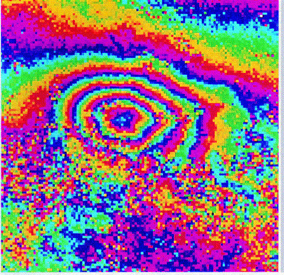
Figure 2. Interferometric ERS image of an earthquake zone in
California's Mojave Desert. The four concentric fringes in the
centre are a map of terrain movements with a maximum value of 112
mm in the direction of the satellite (upwards with 23 degrees
inclination). This movement is interpreted as an aftershock
measuring 5.1 on the Richter scale, which was registered on 4
December 1992, 159 days after the main earthquake. The diameter
of the outermost ring is 5 km. Such measurements of terrain
displacements with millimetre precision, directly from space and
with a minimum of ground surveying, have many potential risk-
management applications. (Image courtesy of D. Massonet et al.,
CNES & CNRS).
During Phase 1 user needs in terms of spacebased resources and/or products were identified for six major risk areas: forest fires, earthquakes, floods (flood plains, torrential floods, snow melt), transportation of dangerous materials, and nuclear and chemical accidents. Accidents that have occurred recently in greater Europe were studied and analysed, workshops were organised by the civil- protection authorities involved in the management of these accidents, and a questionnaire was widely distributed and the replies were synthesised. The resulting user needs were then classified for each of the three phases of the catastrophe, namely prevention, crisis and post-crisis.
The main needs during the prevention phase were identified in terms of models (e.g. hydro-logical), risk area cartography and vulnerability maps. There is also a generic need for routine monitoring and basic weather forecasting.
The major needs during the crisis period were identified as alert monitoring (i.e. with in-creased frequency), cartography of the damage and high-quality weather forecasting. It was also felt necessary to have models simulating the disaster with real data for comparison with the prevention models. The management of the logistical support needed and the rescue effort itself can also be supported by space technologies.
The important needs during the post-crisis phase are those related to damage assessment, and most importantly, the feeding back of disaster data into existing models, in order to improve both their reliability and accuracy.
The main conclusions from this first study phase were that:
This phase, aimed at establishing an inventory of available and planned space resources in greater Europe, was performed as an internal ESA activity. An ESA- prepared questionnaire was addressed to the national space agencies, to Inmarsat, Eutelsat, Eumetsat and to the private European satellite operators (SES, Hispasat, etc.).
The main conclusions that could be drawn from this inventory exercise were that:
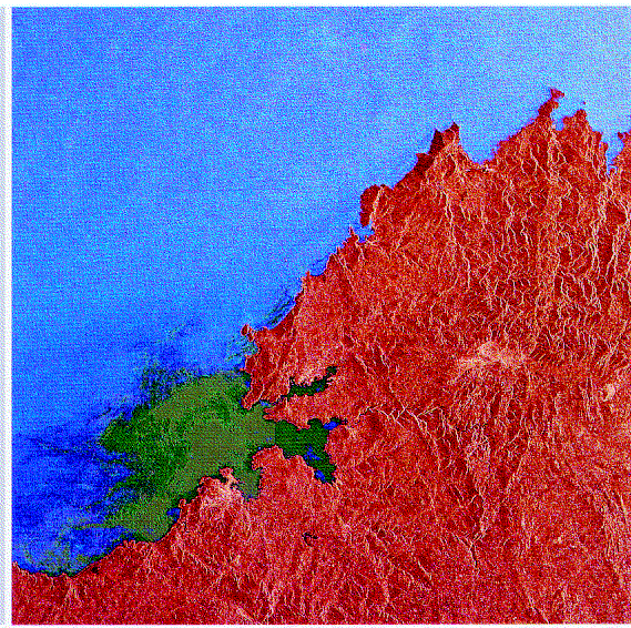
Figure 3. Oil spills, like this one from the wreckage of the
tanker Aegean Sea near La Coruña in Northern Spain on 3
December 1992, provide spectacular examples of the disaster-
management capabilities of ERS-1. This multitemporal image shows
the full extent of the marine pollution on 13 December 1992 (dark
green) and what was still left three weeks later, on 2 January
1994 (lighter green).
The objectives of this phase were to consolidate and possibly complement the user needs identified in Phase 1, validate the space resources identified in Phase 2, and evaluate the match between these needs and existing and planned space resources.
Three scenarios were defined in which space resources are increasingly used for risk-management support, for which a space- based service system was also proposed. The overall findings of this phase were then validated by conducting five practical case studies. Four additional types of risk - volcanic eruptions, storms, droughts and pipeline accidents - were also evaluated during Phase 3 in prevention, crisis, and post-crisis terms.
The user needs expressed in the ESA interviews conducted during Phase 1 were translated into real technical characteristics (parameters) during this phase to allow easier comparison with space-resource capabilities, both present and future, in the five domains of meteorology, data collection and localisation, navigation, telecommunications, and Earth observation.
Compliance between user needs and available technologies was analysed for three scenarios:
The overall finding was that existing space-based resources can cover approximately 60% of foreseen user needs (the exact percentage varying according to the exact nature of the risk/resource: meteorological, communications, observational, etc.). Taking into account planned space-based resources, the degree of compliance rises to approximately 80%.
Some parameters, especially in the field of Earth observation, are technically but not operationally compliant, which could be improved by better data handling and delivery. Some others, in that same field, cannot be obtained successfully due either to poor spatial resolution (e.g. water temperature or topographic height) or inadequate current knowledge (e.g. soil moisture).
In the field of meteorology, the current non-compliance is due to the inability to satisfy very localised needs covering areas of just a few kilometres. Some parameters, such as frozen soil depth, cannot be obtained from space using available or currently planned techniques. The main shortfalls during the prevention and crisis phases are the lack of risk-area cartography and models, and of accurate local weather forecasts. Coverage is better for flood plains and snow-melt flooding than for torrential floods. For volcanoes, however, only 10% of today's needs can be covered from space, although this figure improves to 80% when already planned future space resources are taken into account. As far as forest fires are concerned, almost 60% of needs are covered by current resources, improving to more than 80% with planned resources. The non-compliant items are mostly in the crisis phases, for alert monitoring and damage cartography.
The degree of compliance also varies with the type of space resource. For instance, current meteorology resources can cover about 80% of the needs, the only ones that cannot be covered being those on a very local scale. Current telecommunications and localisation systems can already fully cover user needs. Existing data-collection systems can meet 50% of user needs, but this can be improved to 80% with planned systems. Current Earth- observation systems can cover about 45% of today's user needs, which could be improved to almost 80% with a radar satellite constellation.
The overall conclusion to be derived from Phase 3, therefore, is that there is still a real need to bridge the gap between the space data and service providers on the one hand and the 'users' - civil and governmental authorities involved in risk management on the other.
These authorities need to be both informed and convinced of the usefulness of space techniques for supporting risk management. The feeling that 'space is expensive' needs to be mitigated by reducing the cost of space data and services through the centralised provision to operators of high-quality space data products and services for risk-management applications.
These improvements could be brought about by developing a Space Information Service System, which would firstly educate those involved in risk management in the potential of space-based solutions, and secondly would ensure the timely availability of the space products needed for risk prevention and management in the various disciplines.
Based on the success of the small demonstration projects that ESA conducted during Phase 3, to convince the civil protection agencies and governmental authorities of the usefulness of space techniques for dealing with major catastrophes, there is a need for other small short- term pilot projects providing concrete results directly usable by such authorities. The two pilot projects on floods and earthquakes that have been started in January 1997 have as their objective the setting up and testing, for both real and simulated hazard cases, a service providing users (i.e. authorities in charge of risk management) with Earth-observation- derived products with the shortest possible delay. For the flood pilot project, for instance, which will be performed in cooperation with French, Spanish and Italian civil protection agencies and with the support of the Russian Ministry of the Environment (Emercom), three flood-prone areas (plains) in France, Italy and Spain for which some data already exists, such as digital terrain models or hydrological maps, will be selected.
When a catastrophic event - real or simulated - occurs, the user will then have a point of contact which will activate an 'emergency cell'. This cell will ascertain which satellite may have acquired relevant data at the time of the event, procure the data, interpret it and provide the user as quickly as possible with a readily exploitable product. This product, for instance a flood-extent map or an assessment of the vulnerable areas, may be produced by combining the satellite data with existing data from other sources. An important output from this project will also be the feedback obtained from the lessons learnt during the real or simulated crisis, in order to identify where the existing infrastructures and services can be further improved.
An important aspect in the context of these projects is that the driver must be the requirements expressed by the civil- protection authorities, and not the absolute capabilities of the space techniques themselves.


 ESA Bulletin Nr. 89.