CryoSat-2 technology: double dish for resolving surface echo direction
“The SAR technique, as applied to radar altimetry, is not new,” said Dr Cullen. “The Russian Venera-15 and -16 and American Magellan missions used it, albeit at a different transmit frequency, in the 1980s to map the surface relief of Venus beneath its thick clouds.
"What has improved since then is the underlying technology. Today, we have digital instead of analogue chirp generators to generate the high pulse frequency needed, greatly improving the quality of the signal and signal-to–noise, ratio which is key to reducing the uncertainties to make the end product useful for integration into climate models.
“What is unique to SIRAL is the combining of SAR with the additional, interferometry technique used over ice sheet margins. This opens up an across-track window to track the signal in the varied topography of these areas, which are subject to the greatest changes at the moment and where we’re simply not able to measure the effects to an accuracy which is useful for climate change studies.”
Transmitted radar pulses are scatterered off the variable slopes of the ice sheet margins and the returned echo comes from the closest surface location with respect to the satellite. Over the ocean and sea ice there is no significant slope and so the SAR mode can be used but if there is a slope then the echo comes from either side of the satellite depending on the direction of the slope, and the SAR-Interferometer (SARIn) mode is needed.
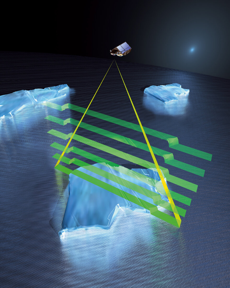
SIRAL receives the returning radar echo with two antennas almost simultaneously. If the echo comes from anywhere but directly below the satellite then there is a difference in the path length this signal echo travels to the two antennas, mounted just over a metre apart. By comparing the differing signal phases, this difference can be measured to high accuracy across 720 km of distance, then used to derive the angle of arrival and therefore echo origin.
“Lack of ability to determine across-track echo location over ice sheet margins is a major problem for existing altimeters,” said Dr Cullen. “Today, with Envisat’s RA-2 altimeter, for example, one uses models of the Antarctic and Greenland to compensate for this problem, but even the very latest digital elevation models (DEMs) are simply not accurate enough over major ice sheet margins, largely because the data going into building them are not accurate enough or already come from conventional radar altimetry which is sparse in these regions.
“Though not the main purpose of the mission, the data from CryoSat-2 will allow development of higher quality DEMs over sheet margins. Such DEMs can be used to reprocess the Envisat and ERS altimeter data, for example, to improve the accuracy of data from that instrument and provide a long and improved time-series necessary for input into climate change programmes.”
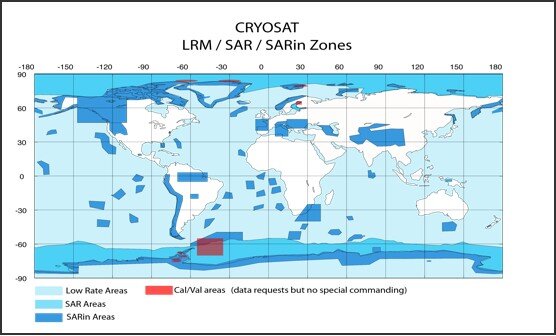
Built within strict mass and budget limitations as an ESA Earth Explorer Opportunity mission, it was not possible to use the SIRAL in its high resolution mode all the time, since the volume of data generated is simply too high. CryoSat-2 employs a series of ‘mode masks’ dictating which operating modes of SIRAL are used where: low-resolution mode resembling standard altimetry over interior land ice, SAR mode over sea ice, and SARIn mode over ice sheet margins, with mode masks updated every two weeks to take account of seasonal changes of the sea-ice extent.