ESA title
Applications

Envisat global land and sea level data now available

01/10/2003 2583 views 4 likes
ESA / Applications / Observing the Earth

ESA is now providing scientific and industrial users with continuously updated satellite measurements of the precise contours of the land, sea and ice surfaces of the Earth.

The new Level 2 products are derived from the Radar Altimeter-2 (RA-2), Microwave Radiometer (MWR) and Doppler Orbitography and Radiopositioning Integrated by Satellite (DORIS) instruments on board ESA’s Envisat environmental satellite.

The data are processed and distributed for ESA by the CLS ('Collecte, Localisation, Satellites') centre in Toulouse and the French space agency CNES ('Centre National d’Etudes Spatiales').

Global wave height measured by Envisat’s RA-2

The resulting products provide researchers with the ability to measure ocean topography, sea ice, polar ice sheets and land elevation with unprecedented accuracy.

The RA-2 works by sending 1800 radar pulses down to Earth each second, then recording how long the pulses take to return. The MWR supports the RA-2 by measuring water vapour levels in the atmosphere and calculating any resultant delay to the radar signal propagation. DORIS is used to assess the satellite’s position and orbital speed. In this way the distance of the satellite from the planet’s surface can be assessed to a maximum accuracy of two centimetres.

Warm ocean currents can cause sea surface height to rise up to a metre above surrounding waters, so radar altimetry provides a means of mapping the circulation of Earth’s oceans – as well as following El Niño events as they develop. Global ocean wave height and wind speed can also be measured simultaneously with the sea surface height, enabling operational sea state forecasting.

Envisat - artist's impression

Envisat was launched into orbit at the end of February 2002. Since then engineers have been kept busy with commissioning the spacecraft’s ten instruments and refining software algorithms used to convert raw data into reliable geolocated products tailored for various specific uses.

The RA-2 represents an especially demanding instrument because of its extreme sensitivity. Raw so-called ‘level 0’ data from the RA-2 and also MWR must be processed through numerous algorithms to be turned into calibrated engineering units and then the RA-2 and MWR data are merged together to become ‘level 1b’ data. Further processing and auxiliary data are then added – such precise orbital information, geophysical corrections, local variations in the gravity field or geoide – to become usable ‘level 2’ data, such as Geophysical Data Record (GDR).

Wind speed measured by Envisat’s RA-2

"The level 2 data products allow scientists worldwide to conduct studies on ocean circulation, marine gravity, sea ice growth and distribution, land and ice topography mapping, and sea level change," explained Remko Scharroo of the Delft Institute for Earth-Oriented Space Research (DEOS), one of the RA-2 Principal Investigators. "Generally the data is merged with in-situ and other satellite data. This can only be done when the data is properly calibrated and the algorithms are validated against external data."

For the RA-2, the post-launch period of calibration (equivalent to 'tuning up' the instrument to make it work as well as possible) and validation (a process of confirming algorithm-generated products match geophysical reality on the ground) is now over. Recommendations for improvements were issued by overseeing Expert Support Laboratories as a result of the Cal/Val exercise, as the RA-2 entered its Operational Phase in early 2003.

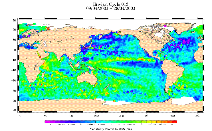
Measuring Sea Level Anomaly

So the new RA-2/MWR GDR data now available are the culmination of team working between ESA engineers, CNES and CLS, ESLs and external scientific support to turn the issued recommendations for algorithms and product improvement upgrades into final reality.

And by processing RA-2 data to level 2 quality, the measurements from other altimetry spacecraft can be merged together with Envisat-originated results for much greater accuracy and resolution. "We need at least two altimeters to get a good operational description of sea level and ocean currents," explained Pierre-Yves Letraon of CLS.

RA-2 sea surface measurements merged with other space-derived altimeter data

A combined ground segment specially developed by CNES for altimetry missions called SSALTO ('Segment Sol multi-mission d'ALTimétrie, d'Orbitographie et de localisation précise') is used to do this. Combining together data from altimeter-equipped satellites such as ESA’s ERS 1 and 2 and Envisat as well as TOPEX/Poseidon, Jason-1 and GFO shows an average rise in global sea level of 2 mm per year during the last decade.
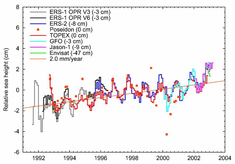
Sea level trends
Sea level trends

The work performed is the first step in the enhancement of the Envisat data quality but not the last. Regular upgrades of the processing chain and related data products are already planned, and shall take place throughout the Envisat mission lifetime to ensure and improve the overall data reliability, quality and adequacy to user needs.

GDR and other level 2 data products are currently available via FTP site since 8 September 2003 and are also about to be receivable via DVD. The ESA Earth Observation Help Desk can provide further information on the RA-2 data availability.

Related Links