Space for the Arctic
International stakeholders met in Copenhagen this week to discuss the contribution of space technologies to one of the regions most affected by climate change.
Rendered increasingly accessible by the melting of ice, the Arctic is being transformed from a region of primarily scientific interest into one attracting a complex set of environmental, security and commercial concerns.
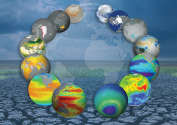
Because of the Arctic’s harsh environment and low population density, space systems offer unique opportunities to monitor this environment. Satellites can facilitate navigation and communications, improve marine safety and monitor changes in a very sensitive region.
The past five years have seen the lowest Arctic sea-ice extent since satellite measurements began in the 1970s. Last August, satellites saw the rare occurrence of two major shipping routes in the Arctic Ocean open simultaneously.
Over the past few years, the Arctic has attracted the political attention of its nations, as well as the EU.
Under the auspices of the Danish Presidency of the EU council, Arctic stakeholders met in Copenhagen this week for the ‘Space for the Arctic 2012’ conference to review the contribution of space assets to the Arctic, identify possible gaps and explore opportunities.
The event was hosted by the Centre for Polar Activities at the Technical University of Denmark, and jointly organised with the Danish Meteorological Institute, the Danish Ministry of Science, Innovation and Higher Education, ESA and the European Commission.
The Danish Minister of Science, Innovation and Higher Education, Morten Østergaard, highlighted the importance and uniqueness of space-based monitoring for the Arctic. He noted that Earth observation data products are playing an important role in climate change sciences, and derived services are contributing to a safer and more sustainable exploitation of the region.
The Kingdom of Denmark – which comprises of Denmark proper, the Faroe Islands and Greenland – plays a major role in the international governance of the Arctic owing to its location.
Last year the three parts of the Kingdom adopted a new, common Arctic strategy that sets out political priorities for the development of the Arctic. At the same time, the EU is continuing its preparations for putting an Arctic policy in place for its Members.
The Director of ESA’s Earth Observation Programmes, Volker Liebig, presented ESA’s Earth-observing capabilities that support operational and scientific applications in the Arctic context, showing how the results play an essential role in understanding the effects of climate change.
ESA is monitoring the Arctic with its Earth-observing satellites, such as Envisat, SMOS and CryoSat-2. Next month, the first map of changes in Arctic sea-ice thickness based on the CryoSat ice mission will be revealed.

Prof. Liebig underlined the point that securing the European financial framework for continued monitoring, especially under the Global Monitoring for Environment and Security (GMES) programme, will be one of the priorities this year.
An on-schedule launch of the GMES Sentinel satellites will be paramount. Delays would upset and interrupt ongoing science and operational use of satellite data.
Several specific recommendations that should be taken up by the Arctic stakeholders came out of ‘Space for the Arctic 2012’, including higher bandwidth satellite telecommunication channels, improved satellite-based navigation systems, and trans-Arctic monitoring of sea ice and icebergs to increase safety of navigation.
Strong international cooperation will be required to make progress. Owing to the vast geographic regions involved, sharing capacities between the stakeholder countries will be essential.