International Symposium on Radar Altimetry in Venice, 13 to 18 March 2006
The life of Venetians is strictly connected to the sea-level, which is one of the reasons why Venice was chosen to host the international symposium “15 Years of Progress in Radar Altimetry” – a major scientific event on a class of space-borne sensor that precisely records the height of the global sea surface along with that of freshwater bodies, land surfaces and the icy cryosphere.
Organised by the European Space Agency (ESA) together with the French Space Agency (CNES), the '15 Years of Progress in Radar Altimetry' symposium is being held in Venice Lido from 13 to 18 March 2006.
The symposium takes place a few weeks after ESA received the green light from its Member States to build and launch a CryoSat recovery mission, Cryosat-2, which is expected to be launched in March 2009.

Thanks to its main instrument, the Synthetic Aperture Interferometric Radar Altimeter (SIRAL), CryoSat-2 will precisely monitor changes in the elevation and thickness of polar ice sheets and floating sea ice. These data will help explain the connection between the melting of the polar ice and the rise in sea levels and how this is contributing to climate change.
Radar altimeters were first flown in space in the 1970s, aboard NASA's Skylab, Geos 3 and Seasat. Initially these sensors were dedicated to the study of oceans, but as the technology improved so did their reach. The European experience in radar altimetry dates back to 1991, when ESA launched its ERS-1 satellite, which included the first Radar Altimeter (RA), precisely calibrated over the water of Venice. Since then, ESA has continued to accumulate homogeneous data by follow-up instruments aboard ERS-2 and Envisat satellites.
In 1992, as a support to the World Ocean Circulation Experiment program, NASA and CNES launched the Topex/Poseidon mission, fully optimised to measure the sea surface topography with an unprecedented accuracy of a few centimetres.

The Topex/Poseidon mission was completed at the end of 2005, after 13 years of successful and continuous ocean surveys. Its successor, Jason-1, was launched in 2001 and the launch of Jason-2, a joint CNES/NASA/EUMETSAT/NOAA mission, is scheduled to take over in 2008.
Since its launch in 2002, from its 800-km-high polar orbit, Envisat's Radar Altimeter-2 (RA-2) sends 1800 separate radar pulses down to Earth per second then records how long their echoes take to bounce back. The sensor times its pulses' journey down to under a nanosecond to calculate the distance to the planet below to an accuracy of two centimetres.
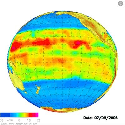
Radar altimetry is valuable to several scientific and application fields like monitoring El Niño events, mapping ocean currents – such as the Gulf Stream – and quantifying the impact of global warming on sea levels.
Along with other space techniques and in-situ networks, altimetry is also a key component of emerging ocean forecast operational systems which provide, several days/weeks in advance, essential information for ship routing, oil spill drift monitoring, marine resource management and climate forecasting.
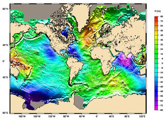
Radar altimetry also allows researchers to peer indirectly beneath the waves: undersea bathymetry features are revealed by persistent, slight undulations of the marine geoid – the equipotential surface in the gravity field of the Earth that coincides with the undisturbed mean sea level – created by minor variations in the Earth's gravity due to the sea floor relief.
Over land, radar altimetry delivers enhanced digital elevation models (DEMs), and recent improvements in processing algorithms have made it possible to monitor the levels of rivers and lakes, allowing more precise quantifying of the vast amounts of freshwater that flows across Earth's land surface.
For the Cryosphere – those regions of the Earth where water freezes – radar altimetry has been successful in measuring the mass balance of Greenland and Antarctic ice sheets and providing initial global monitoring results for sea ice thickness.

Along with this symposium, three related events are scheduled to take place in Venice the same week: the annual meeting of the Ocean Surface Topography Science Team (OSTST – particularly concerned with GFO, Topex/Poseidon, Jason-1/2 and Envisat altimetric missions), the International DORIS Service (IDS) Workshop and the ARGO Workshop.
DORIS (Doppler Orbitography and Radiopositioning Integrated by Satellite) is an onboard satellite radio receiver used for precise orbit determination. DORIS derives it to an accuracy of a few centimetres by detecting and measuring the Doppler shift on signals broadcast from a network of more than 50 radio beacons spread across the world. These data are precious tools for improving the accuracy of altimetry measurements. DORIS receivers are aboard many satellites including Envisat and CryoSat.
ARGO is the name for an array of more than 2000 profiling floats which provide temperatures and salinity profiles for various depths across the global ocean. ARGO results are scientifically valuable in their own right but can also be combined with altimetry data for enhanced environmental and climate knowledge.
A media opportunity will be organized at the ESA/CNES stand at the end of the opening session (12:30 CET). Media representatives will be able to meet Volker Liebig, ESA Director of Earth Observation Programmes and Philippe Goudy, Director of Orbital Projects, CNES. Other ESA and CNES experts will also be available for interviews.
Media representatives wishing to attend are kindly requested to complete the attached accreditation form.
For further information please contact:
ESA: Simonetta Cheli
Head of Public and Institutional Relation Office
Tel. +39 06 941 80 350
CNES: Sandra Laly
Press Officer
Tel. +33 1 447 67 732