Envisat
| ROLE | Earth observation (EO) |
| LAUNCH DATE | 1 Mar 2002 |
| LAUNCHER/LOCATION | Ariane 5/Kourou, French Guiana |
| LAUNCH MASS | 8100 kg |
| ORBIT | Sun-synchronous, polar, 782 km |
| PERIOD | 100 minutes |
| NOMINAL MISSION | Complete |
| + Largest Earth observation satellite ever flown + | |
The mission

Envisat provided continuous observation and monitoring of the Earth's land, atmosphere, oceans and ice caps. Due to its near-Earth polar orbit (782 km mean altitude) and fast cycle time (one orbit in 100 minutes), the mission presented unique challenges for ground communications and data delivery.
Envisat data continue to provide a wealth of information on processes of the Earth's systems, including insights into factors contributing to climate change. At one time, more than 2700 scientific projects worked with Envisat data as well as other operational users, who used data from Envisat for non-scientific activities on a routine, operational basis (e.g. earther services) or for commercial uses.
Just weeks after celebrating its tenth year in orbit, communication with Envisat was suddenly lost on 8 April 2012. Following rigorous attempts to re-establish contact and the investigation of failure scenarios, the mission was declared over on 9 May 2012.
Editor's note: This article will no longer be updated and contains some information that is now out of date.
The Envisat Flight Operations Control Centre (FOCC) was located at ESOC, Darmstadt, Germany.
The Flight Control Team

The Flight Control Team operates from the combined Earth observation Dedicated Control Room located at ESOC.
Spacecraft Operations Manager (SOM) Frank-Jürgen Diekmann, from Germany, manages the team, which was responsible for command and control, on-board software and database maintenance and mission planning for the satellite. "I joined the Envisat team in 1995 and have been SOM since 2006. Besides all the necessary technical and administrative obligations involved in managing the operations of an EO satellite, I am still enthusiastic about the complexity and the beauty of our blue planet," says Diekmann.
The team operated a 7-day-per-week on-call service for engineering and mission planning, ensuring a fast reaction in case of any on-board anomalies, ground segment problems or unforeseen re-planning requests from the Envisat user community.
Mission operations overview
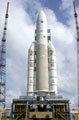
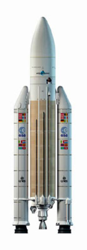
Envisat was launched on Ariane-5 Flight V145 on 1 March 2002 from Europe's Spaceport in Kourou, French Guiana. After a perfect launch and injection into its Sun-synchronous polar orbit, the critical LEOP (Launch and Early Orbit Phase) began with an autonomous sequence, including solar array deployment.
Launch and Early Orbit Phase
The solar array drive mechanism and reaction wheel release pyros were then fired and the Earth-pointing attitude was acquired as planned.
On Day 2, the satellite performed orbit control manoeuvres to start moving toward the planned orbit. On Days 3 and 4, the ASAR (Advanced Synthetic Aperture Radar - the largest single instrument on Envisat) antenna was successfully deployed, marking the end of LEOP.
Commissioning Phase
The commissioning phase began with the Payload Switch-on and Data Acquisition Phase (SODAP) on 5 March 2002.
The Payload Module Computer was switched on first. During this phase, all operational modes of the Payload Equipment Bay (PEB) and the instruments were successfully exercised. The remaining payload deployments of the Ka-band antenna and instruments (GOMOS, MIPAS, SCIA) were performed. SODAP finished in mid-April 2002, at least for the majority of the instruments.
Cal/Val Phase
The second half of the commissioning phase, the so-called 'Cal/Val' (calibration and validation) activities, started next. In September 2002, the first calibration review occurred at ESA/ESTEC, confirming the promising scientific results already being received. A second validation review, to mark completion of the commissioning phase, took place in December 2002.
Routine operations
Since 1 January 2003, Envisat's flight operations and ground segment have operated in the 'routine operations' phase. After nine years in-orbit operations, the satellite has completed over 46 000 orbits, covering 2 billion km since launch. Over 280 gigabytes (GB) of science data are generated each day, contributing to the growing 750-terabyte (TB) database.
The Flight Control Team conducts orbit manoeuvres approximately every three to four weeks. These maintain the actual ground track within the required ± 1 km variation from the reference.
More than 2000 nominal and contingency procedures have been developed and tested by the Flight Control Team. As with any complex satellite, different types of anomalies of the satellite platform and payload have to be investigated and require ongoing meetings, training and reporting, as well as upgrading of operational procedures.
Mission planning systems at ESOC and ESRIN plan and schedule operations for the payload and the data management system on a routine basis. The planning cycles are about 5 days for nominal operations and less than two working days for emergency requests. Commands are uplinked to the on-board queue up to 24 hours before their execution. Up to 230 000 commands are transmitted to the satellite every month.
Mission extension
In June 2009, ESA Member States unanimously voted to extend the Envisat mission through to 2013.
The operational scenario for extending the mission had already been defined in 2008 and was based on altitude lowering and a new orbit control concept, allowing a continuation of the routine operations until the end of 2013. The orbit change became necessary, to avoid further fuel consumption (the main life= limiting resource onboard ENVISAT) for inclination manoeuvrers.
The Flight Control Team at ESOC was responsible to implement the orbit lowering manoeuvrers and resume nominal operations afterwards. These activities were carefully planned, tested and finally successfully executed in October and November 2-1-. After a series of manoeuvrers ENVISAT is now orbiting the Earth at an average altitude of 782 km with a repeat cycle of 30 days and a slowly drifting inclination.
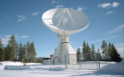
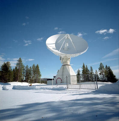
The ground station
Kiruna, Svalbard
Envisat, following a Sun-synchronous low-Earth orbit of about 782 km altitude with a 30-day repeat cycle, presents unique challenges for telecommanding and data download.
For routine operations, mission controllers use the Kiruna ground station - part of ESA's ESTRACK global network - for command, control and tracking of the satellite during visible orbits. Additional capacity is provided by the Svalbard ground station and others. During blind orbits over Kiruna, engineers monitor the satellite using two Svalbard passes during the night.
Artemis

Envisat also communicates using a direct Ka-band link to the advanced Artemis data-relay satellite. Data is relayed in space from Envisat to Artemis, and then downloaded to the payload data handling stations at ESA/ESRIN in Frascati, Italy.
This relay enables on-board instruments to continuously gather high-rate data (which cannot be stored on board) and permits engineers to optimally manage the satellite's solid-state memory.
Ground segment & mission control system

The Envisat ground segment at ESOC uses the SCOS-1b mission control system, based on ERS-2 heritage. The ground segment comprises:
- Flight Operations Segment (FOS): Responsible for command and control of the satellite
- Payload Data Segment (PDS): Responsible for exploitation of the instrument data
The FOS is responsible for:
- Command and control of the Envisat satellite
- Satellite operations planning - based on the observation plans prepared by the Payload Data Segment
- Mission planning interface with Artemis
- Uploading of operation schedules three times daily via the Kiruna and Svalbard ground stations
- Satellite configuration and performance monitoring
- Software maintenance
- Orbit prediction, restitution and maintenance
- Contingency and recovery operations, as necessary
The Flight Operations Control Centre hosts the following major subsystems:
- Mission Control System based on SCOS-1b
- Flight Dynamics System (FDS) - derived from the ORATOS system, already used on the ERS missions (the major upgrade was the addition of the star tracker control and performance monitoring)
- Mission Planning System (MPS) - schedules payload and data handling activities normally one week in advance, but new command schedules can be generated in less than 24 hours if necessary
- The Envisat satellite simulator - software that is as representative as possible of the on-board software for all aspects related to satellite control in all mission phases (LEOP, routine operations and contingencies); this simulator includes emulation of the flight software and simulations of other satellite subsystems, including the Instrument Control Units. The main objective is to permit rehearsals of all critical operations as well as to train operators in nominal and contingency procedures.
- Performance Archiving System (SPEVAL) - permits storage and retrieval of all satellite control and monitoring information through the complete mission lifetime, also via Internet access.
- Satellite Software Maintenance Facility - based on software maintenance tools delivered by the satellite and instrument manufacturers
- Satellite control database - includes libraries of 6000 commands, 25 000 telemetry parameters and over 2000 telecommand sequences
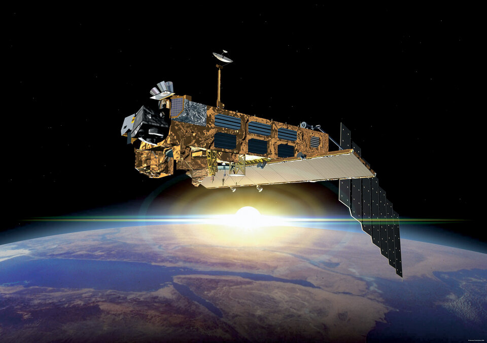
The platform and payload
The platform
Envisat's total mass is 8.1 tonnes including a payload mass of around 2.1 tonnes and around 314 kg of hydrazine thruster fuel (at beginning of life). A 14x5-metre solar array made of silicon cells and eight nickel-cadmium batteries supply an average power of 6 kilowatts in sunlight and 3 kilowatts during eclipse, of which on average 2 kilowatts is available for instruments.
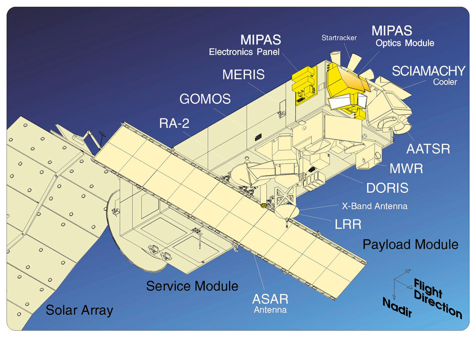
Envisat's major system elements:
- a Service Module (SM) - accommodating most of the satellite support systems, including launcher interface, Attitude and Orbit Control (AOCS), Power Generation and Regulation, Thermal Control, Data Handling Sub-system (DHS) and S-band Communications
- a Payload Module (PLM) - on which the instruments are mounted and which houses payload support functions, also known as PEB, such as Payload Data Management including a dedicated Payload Management Computer (PMC), X- and Ka-band Communication Sub-systems for downlinking scientific data, and Thermal Control and Power Distribution
- a suite of 10 scientific instruments operating over a wide range of the electromagnetic spectrum from microwave to ultraviolet; this includes, among others, an Advanced Synthetic Aperture Radar (ASAR) for high-resolution (30x30 metres) wide-swath radar images, several optical and IR instruments for monitoring the Earth's land areas, oceans and atmosphere and a precise orbit determination instrument
The solar array is pointed at the Sun using a solar-array drive mechanism. A hydrazine propulsion system provides the control torque for attitude acquisitions as well as the thrust required for orbit control manoeuvres. An independent safe mode electronics system is implemented on board; if there is a satellite emergency, this ensures that the satellite can acquire a safe attitude that allows the solar array to point to the Sun.
More than 50 on-board processors are available in a decentralised on-board architecture with different software packages maintained by the Flight Control Team when in orbit. For Telemetry (TM), Telecommand (TC) and Tracking, an S-band transponder with a TM bit rate of 4 kbps and a TC bit rate of 2000 bps is available. Science data can be stored on two solid-state recorders having 70 Gigabits of memory each. The data can then be downlinked either in X-band (2 x 100 Mbps) direct-to-ground or in Ka-band (2 x 100 Mbps) via Artemis.
The payload
Envisat's payload comprises:
|
Instrument |
Name |
|
ASAR |
An Advanced Synthetic Aperture Radar (ASAR), operating at C-band, ASAR ensures continuity with the image mode (SAR) and the wave mode of the ERS-1/2 AMI. |
|
MERIS |
MERIS is a programmable, medium-spectral resolution, imaging spectrometer operating in the solar reflective spectral range. Fifteen spectral bands can be selected by ground command, each of which has a programmable width and a programmable location in the 390 nm to 1040 nm spectral range. |
|
AATSR |
The prime scientific objective of the Advanced Along Track Scanning Radiometer (AATSR) is to establish continuity of the ATSR-1 and ATSR-2 data sets of precise sea surface temperature (SST), thereby ensuring the production of a unique 10 year near-continuous data set at the levels of accuracy required (0.3 K or better) for climate research and for the community of operational as well as scientific users who have been developed through the ERS-1 and ERS-2 missions. |
|
RA-2 |
Radar Altimeter 2 (RA-2) is an instrument for determining the two-way delay of the radar echo from the Earth's surface to a very high precision: less than a nanosecond. It also measures the power and the shape of the reflected radar pulses. |
|
MWR |
The main objective of the microwave radiometer (MWR) is the measurement of the integrated atmospheric water vapour column and cloud liquid water content, as correction terms for the radar altimeter signal. In addition, MWR measurement data are useful for the determination of surface emissivity and soil moisture over land, for surface energy budget investigations to support atmospheric studies, and for ice characterisation. |
|
GOMOS |
GOMOS measures atmospheric constituents by spectral analysis of the spectral bands between 250 nm to 675 nm, 756 nm to 773 nm, and 926 nm to 952 nm. Additionally, two photometers operate in two spectral channels; between 470 nm to 520 nm and 650 nm to 700 nm, respectively. |
|
MIPAS |
The Michelson Interferometer for Passive Atmospheric Sounding (MIPAS) is a Fourier transform spectrometer for the measurement of high-resolution gaseous emission spectra at the Earth's limb. It operates in the near to mid infrared where many of the atmospheric trace-gases playing a major role in atmospheric chemistry have important emission features. |
|
SCIAMACHY |
SCIAMACHY is an imaging spectrometer whose primary mission objective is to perform global measurements of trace gases in the troposphere and in the stratosphere. |
|
DORIS |
The Doppler Orbitography and Radio-positioning Integrated by Satellite instrument is a microwave tracking system that can be utilised to determine the precise location of the ENVISAT satellite. |
|
LRR |
The LRR is a passive device which is used as a reflector by ground-based SLR stations using high-power pulsed lasers. In the case of Envisat, tracking using the LRR is principally accomplished by the International Laser Ranging Service (ILRS). |