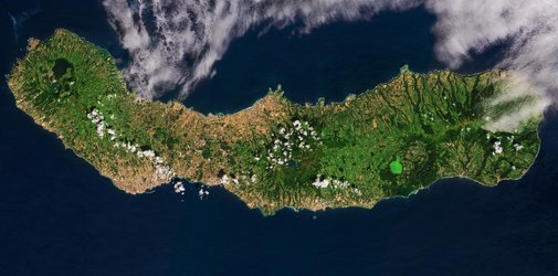
The Azores, Portugal - ASAR - 28 March 2004
This Advanced Synthetic Aperture Radar (ASAR) displays 4 islands of the Portuguese archipelago of the Azores. The 4 of which there are 9 major islands in total are, to the west; Faial, south; Pico, east; Sao Jorge and to the north; Graciosa.
All 4 of these islands, as are all the Azores except one, are volcanic. Periodic eruptions and earthquakes have devastated the islands through history. The highest point on the islands is the volcano of Pico Alto (2,351 m) situated on Pico, and easily visible in the image. The Volcano had it last large-scale eruption in 1963.
Technical Information:
Instrument: Advanced Synthetic Aperture Radar (ASAR)
Date of Acquisition: 28 th March 2004
ASAR Features: Image Mode Precision (30 meter resolution)
ASAR Mode: Image Swath 2 (104.8 km wide)
Orbit Direction: Descending
Orbit Number: 10856
ASAR Polarisation: VV
Coordinates:
NE Lat/Long: N 39.02 / 27.44 W
NW Lat/Long: N 39.22 / 28.63 W
SW Lat/Long: N 38.28 / 28.88 W
SE Lat/Long: N 38.09 / 27.70 W