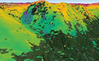
• → European Space Agency

      • Space for Europe
      • Space News
      • Space in Images
      • Space in Videos
    • About Us

      • Welcome to ESA
      • DG’s blog
      • For Member State Delegations
      • Business with ESA
      • Law at ESA
      • ESA Exhibitions
      • ESA Publications
      • Careers at ESA
      • ESAshop
    • Our Activities

      • Space News
      • Observing the Earth
      • Human and Robotic Exploration
      • Space Transportation
      • Navigation
      • Space Science
      • Space Engineering & Technology
      • Operations
      • Telecommunications & Integrated Applications
      • Preparing for the Future
    • Careers at ESA

    • For Media

      • Media
      • ESA TV
      • Videos for professionals
      • Photos
    • For Educators

    • For Kids

    • ESA

    • Space in Videos

    • ESA Web-TV

    ESA > Space in Videos > 2014 > 08 > Norwegian fringes

    Free Search (4196 videos)

    Norwegian fringes

    Loading...
    • Watch in:
    • en
    DOWNLOAD MP4 (19.67 MB) SOURCE MP4 (36.21 MB)

    Embed Code

    Details

    Open/Close
    • Title Norwegian fringes
    • Released: 26/08/2014
    • Length 00:00:51
    • Language English
    • Footage Type Animation
    • Copyright Copernicus data (2014)/ESA/Norut–SEOM Insarap study (video animation data: Norwegian Mapping Authority and NASA)
    • Description

      The animation, which is based on an interferogram generated with two radar images captured by Sentinel-1A  in ‘Interferometric Wide-Swath’ mode on 11 and 23 August 2014, mainly shows topography around the northern coast of Norway.  Although Sentinel-1A is still being commissioned, this new result demonstrates how useful it will be to map the shape of the land and monitor ground movement. Synthetic aperture radar interferometry – or InSAR – is a technique where two or more satellite radar images acquired over the same area are combined to map topography and detect surface changes. Small changes on the ground cause changes in the radar signal phase and lead to the rainbow-coloured fringes of an ‘interferogram’. In this case, the animation denotes differences in topography.

      Since the area around the Lyngen Alps is particularly prone to landslides, it is closely monitored. Large landslides that suddenly shift rock into the sea could potentially create tsunami-like waves. In 1810, such a wave destroyed a village, and, history shows that this kind of natural disaster occurs a couple of times every 100 years in Norway. InSAR is an important tool used by the Norwegian authorities to map rockslide hazards nationwide. The unprecedented coverage offered by the Sentinel-1 mission will significantly increase the value of InSAR data for this purpose.


    TAGS

    Open/Close
    • Click on the tags to find the matching videos.
    • Activity Observing the Earth
    • Keywords Earth observation , Geology, Mountain, Radar, Radar altimetry, Radar data
    • Set Sentinel-1 video gallery

    TAGS

    Open/Close

    Details

    Open/Close

    Rate this

    Views

    Comments

    Share

    • Currently 5 out of 5 Stars.
    • 1
    • 2
    • 3
    • 4
    • 5

    Rating: 4.9/5 (13 votes cast)

    Thank you for rating!

    You have already rated this page, you can only rate it once!

    Your rating has been changed, thanks for rating!

    5356 0
    Tweet

    COMMENTS

    Open/Close

    COMMENTS

    Open/Close

    RELATED VIDEOS

    • 26 August 2014 Sentinel-1 monitoring motion 14199 Votes: 16
    • 24 March 2015 2015 Fringe Workshop: Part 2 594 Votes: 2

    Related links

    • Copernicus

    • Sentinel-1

    USING OUR VIDEOS

    Terms and Conditions

    Help

    Contact us

    Commenting guidelines

    • Connect with us
    • Subscribe
    • mobile version
    • FAQ

    • Site Map

    • Contacts

    • Terms and conditions