Meeting navigation requirements
EGNOS has three main functions to enable it to meet navigation requirements. These are supplied by the: Ground Integrity Channel (GIC), Wide Area Differential (WAD) and ranging.
Ground Integrity Channel
The Ground Integrity Channel (GIC) provides information on the integrity of the information supplied by the system. By integrity is meant the system’s ability to provide timely and valid warnings to the user.
The integrity parameters are:
alert limit: the amount of error that can be tolerated before an alert is given
time to alert: the maximum allowable time that can elapse before the equipment gives the alert.
probability of non integrity: the probability that during use an error above the alarm limit in the computed position will not be detected within the specified time
Wide Area Differential
Wide Area Differential (WAD) gives any corrections that need making to the GPS/GLONASS data in order to improve the accuracy of the signals.
Ranging
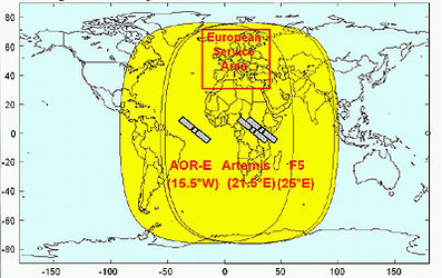
Ranging Integrity Monitoring Stations (RIMS) receive ranging signals generated by the two existing constellations GPS and GLONASS, and from geostationary satellites, as well as atmospheric data.
This information is transmitted through the EGNOS Wide Area Network (EWAN) to one of the Master Control Centres, this then computes the corrections needed for each satellite and incorporate the information into a signal. This will be sent via terrestrial networks to a Navigation Land Earth Station and then transmitted to a geostationary satellite. The geostationary satellite will broadcast the signal to users equipped with specially designed EGNOS receivers.
The whole of this process takes place in a matter of seconds.