CryoSat – a satellite with an icy mission
On 8 February the ESA Director of Earth Observation, José Achache, signed the contract confirming that Astrium will build the new European environmental and climate satellite CryoSat.
The satellite is planned for an April 2004 launch into a polar orbit and will measure changes in the thickness of ice sheets and polar ocean sea-ice cover with unprecedented accuracy for at least three years. The satellite will provide climate researchers with data previously not available from these uninhabited regions. The industrial contract, worth some 70 million euros, involves a number of European partners, in particular Alcatel Space Industries, which is responsible for the SIRAL instrument.
The evidence of climate warming can no longer be ignored. As the Intergovernmental Panel on Climate Change confirmed in its most recent (2001) report: the average global surface temperature rose by 0.6 degrees in the 20th century; the year 1998 was the warmest since 1861, when instrumental recording started. Climate data estimate that the 20th century was the warmest in the last thousand years. At the same time, the concentration of greenhouse gases in the atmosphere, such as carbon dioxide and methane, have grown by 30 and 150 percent respectively as a result of human activities.
Using the models available at the moment, it is only partially possible to predict how these developments affect the climate. The predictions range between global warming of between 1.4 and 5.8 degrees centigrade in the next hundred years. Experts accordingly expect some polar ice and glaciers to thaw. This could result in the water level of the oceans rising by up to a metre.
Polar ice as a climate factor
The presence of ice at the poles plays a central role in determining the global climate. Despite being thousands of kilometres from the most inhabited areas, this ice has a profound effect on the climate in Europe, Asia and the Americas. Three aspects are most important:
- snow and ice reflect sunlight extremely well,
- sea-ice cover insulates the water underneath, and
- large amounts of thawing ice can affect large-scale ocean currents.
Polar ice reflects a large portion of sunlight, and the amount of the absorbed and reflected light is balanced with the climate. If the polar ice begins to melt, less sunlight is reflected and therefore the polar region warms up. Consequently, more ice begins to melt and the reflective capabilities are thus further reduced. Due to this positive feedback effect, self-accelerating warming ensues.
In the night, open water radiates a large heat output of about 90 watts per square metre. A snow-covered sea-ice slab floating on the ocean has a negative effect on this. To a certain extent, it acts as a thermal blanket and therefore plays a significant part in regulating the heat balance of the Earth. This effect is reduced as soon as the ice thins or decreases in extent.
Ocean currents have a special influence on the climate. They act as heat pumps, as they disseminate the energy stored in the oceans around the entire globe. The best known example is the Gulf Stream. This transports warm water from the tropics diagonally over the Atlantic to North Europe and maintains the mild English climate and ice-free ports up to North Scandinavia. If the ice sheets and the outer sea ice cover melt, the relatively larger quantities of fresh water could disrupt or even change these ocean currents – with unforeseeable effects on the climate.
CryoSat – the first mission of ESA´s "Living Planet" programme
A large part of the uncertainties in the climate models of today is due to the lack of precise measurements of polar ice and its development. Experts conjecture that sea ice has receded by 10 to 15 percent since 1950. The thickness of the Arctic ice is reported to have reduced by 40 percent in the past few decades. These statements, however, are extremely uncertain, due to the lack of widespread information on sea-ice thickness.
CryoSat should fill in this gap in climate research. The satellite will start as the first Earth Explorer mission of ESA´s "Living Planet" programme, created in 1998. This science-driven programme, whose target is to provide critical observations to address pressing scientific questions, involves Core Missions, which comprise relatively complex and innovative Earth Observation satellites (costing about 350 million euros), and Opportunity Missions, which will use maturer technology currently available in industry, thus allowing speedier implementation.
CryoSat will be the first Earth Explorer Opportunity Mission. In July 1998, ESA called upon all scientists from its member countries for mission proposals for this programme. Researchers from University College London and other collaborating institutes were supported by employees of Astrium in proposing CryoSat. Astrium´s early engagement in this mission was unusual, which secured cost-effective realisability through simple and effective technical concepts as from the first phase. In April 1999 the ESA programme board selected CryoSat from 27 projects submitted.
Radar Altimeter measures ice thickness
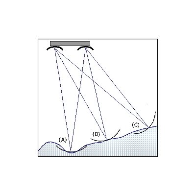
CryoSat will circle the Earth in a polar orbit 720 km high. From there, its radar will measure the thickness and circumference of the polar ice sheets and sea-ice cover. Radar satellites to date, such as the European ERS 1 and 2, have been equipped with only one antenna, delivering information about uniform ice surfaces over a large area. CryoSat, on the other hand, will have two antennae. Similar to the way in which humans, with two eyes, can see spatially, CryoSat´s double radar will be able to scan the upper surface very precisely. This is known as radar interferometry. With this system, an average accuracy of one to three centimetres can be achieved. Thus it can also collect data on inhomogeneous ice structures in the polar seas and glaciers or ice sheets with very steep walls.
In order for this extreme precision of measurement to be attained, the orbiting altitude of the satellite must be constantly known. To determine this to within a few centimetres, CryoSat will use the DORIS system developed by CNES, the French space agency. In this system, ground stations emit signals, which are received and processed by an instrument on board the satellite. The information on satellite altitude so calculated is then transmitted back to the ground station.
CryoSat´s outer side also sports a laser retroreflector. Similar to cats´ eyes on warning signs on the side of a road, it reflects a ray of light. When a ground station sends a laser beam to CryoSat and receives the reflected signal from the satellite, it will be possible to determine the altitude of the satellite from the transit time.
CryoSat´s radar altimeter will function regardless of daylight, also penetrating clouds. Therefore, it is particularly suited to research on large polar ice sheets, which rise up to 4000 metres above sea level and are often covered by cloud. The data from the CryoSat mission should deliver information about the rate of change in these ice sheets.
Working with a tight budget
Astrium is the prime contractor for CryoSat and thus responsible for a consortium of some 30 firms. Astrium itself supplied the satellite platform and will later take on integration of all the instruments. Ultimately, Astrium is responsible to ESA for the reliability of the whole satellite.
Astrium´s engineers face a triple challenge with the CryoSat project from the word go, as they have to combine high reliability, rapid execution and low cost. In order to meet this challenge, Astrium developed a satellite model which is based on simplicity. For example, development mechanisms and additional costly control systems have been left out. During CryoSat´s construction, Astrium and its contractors will largely rely on established hardware components. Added to this, the close partnership between scientists, ESA and the industrial consortium facilitates a loose managemental structure and, related to this, faster response time during the development and construction phases.