
Earth from Space: The Mighty Mississippi
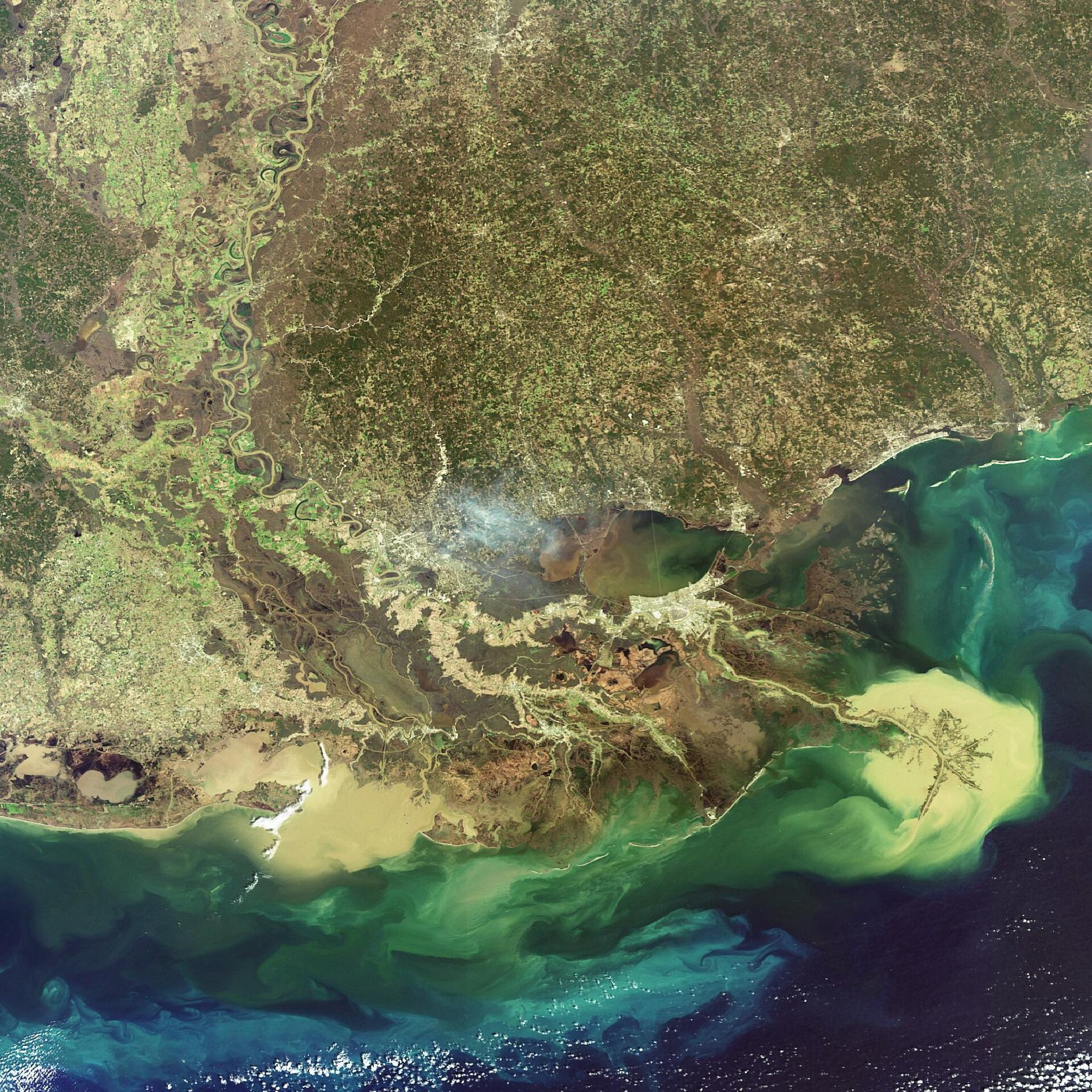
The Mississippi River Delta empties sediment into the Gulf of Mexico in this Envisat image acquired on 6 February 2007. The delta’s water source comes from the United States’ largest river, the Mississippi, which begins its 3 780 km-journey in northern Minnesota, flows south through Wisconsin, Iowa, Illinois, Missouri, Kentucky, Tennessee, Arkansas, Mississippi and Louisiana before spilling into the gulf.
The drainage area of the Mississippi and its tributaries is approximately 3 250 000 sq km and covers about 40 percent of the continental U.S., making it the largest drainage system in North America and the third largest in the world. Discharging 16 800 cubic metres per second, the Mississippi River system is also the sixth largest discharge system in the world.
The size of the Mississippi River Delta increased over millions of years due to sediment deposition. The tons of sediment carried by the river system created the wetlands in southern Louisiana, which are home to many endangered species and help to protect the mainland from hurricane winds by acting like speed bumps.
Over the last several decades, however, the delta’s sediment load has been drastically reduced by natural and man-made factors, causing extensive land loss at the rate of nearly 65 sq km per year. This rate of loss, which is mostly wetland loss, is equivalent to losing a chunk of land only slightly smaller than a football field every thirty minutes. If this process continues at the current pace, Louisiana could be left with less than 5 percent of the wetlands it had in the 1930s.
As wetlands erode, parts of Louisiana, such as New Orleans (the light yellow crescent just below the inland lake, Lake Pontchartrain), become completely exposed to storms coming in from the gulf. Many scientists attribute the scale of disaster of Hurricane Katrina in 2005 to the loss of surrounding wetlands.
In 1971 an inter-governmental treaty established the Ramsar Convention on Wetlands, setting up a framework for the stewardship and preservation of wetlands. Today more than 1 310 wetlands have been designated as Wetlands of International Importance, a total area of 111 million hectares.
GlobWetland, an ESA-led initiative in collaboration with the Ramsar Convention Secretariat, has been using satellite imagery to provide detailed wide-area views of individual wetlands to aid national and local conservation efforts.
With wetlands often made up of difficult and inaccessible terrain, satellites can help provide information on local topography, the types of wetland vegetation, land cover and use and the dynamics of the local water cycle. In particular radar imagery of the type provided by Envisat is able to differentiate between dry and waterlogged surfaces, and so can provide multitemporal data on how given wetlands change seasonally.
Envisat's Medium Resolution Imaging Spectrometer (MERIS) instrument acquired this image working in Full Resolution mode to provide a spatial resolution of 300 metres.

