
Satellites support impact assessment after Türkiye–Syria earthquakes
Türkiye and Syria are reeling from one of the worst earthquakes to strike the region in almost a century. Tens of thousands of people have been killed with many more injured in this tragedy.
Satellite data are being used to help emergency aid organisations, while scientists have begun to analyse ground movement – aiding risk assessments that authorities will use as they plan recovery and reconstruction, as well as long-term research to better model such events.
The initial 7.8-magnitude tremor in southeast Türkiye and northern Syria was followed by another of 7.7 magnitude – causing widespread destruction in both countries. The death toll from the earthquakes has risen to more than 33 000 as of today, with death toll continuing to rise as rescuers scramble to search for survivors trapped beneath the rubble.
The initial earthquake on 6 February, one of the most powerful seismic quakes that the region has experienced in the last century, emanated from a fault line approximately 18 km below the surface. This shallow depth meant the earthquake produced violent shaking that affected areas hundreds of kilometres from the epicentre, around 23 km east of Nurdagi, Gaziantep province.
The second quake followed around nine hours later, striking the Turkish town of Ekinözü, around 60 km to the north, with hundreds of smaller aftershocks occurred in subsequent days.
First response
In response, Turkish authorities, along with the United Nations and the International Federation Red Cross & Red Crescent Societies, activated the International Charter ‘Space and Major Disasters’. By combining Earth observation assets from different space agencies, the Charter provides satellite images of the affected areas to define the extent of the disaster and support local teams with their rescue efforts.
Following the activation, more than 350 crisis images from 17 space agencies across the world were delivered. They can be used to generate damage and situation maps to help estimate the hazard impact and manage relief actions in the affected areas.


Access the video
The maps can be used by rescuers to orient themselves amongst the rubble, identify which roads to take, which bridges to avoid in case of collapse. The data will help guide them to destroyed buildings in remote areas, where help is hard to get.
Along with the Charter, the Copernicus Emergency Mapping Service (CEMS) has also been activated. The service, which has a cooperation agreement for sharing data and collaborating with the Charter, also uses observations from multiple satellites to provide on-demand mapping.
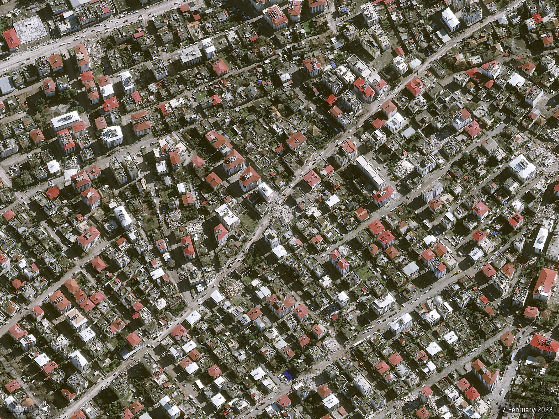
In this case, damage grading maps from the service show the geographic extent of damaged areas. The service used high-resolution optical images, including those from Pleiades over 20 areas of interest covering an area of 664 sq km.
Philippe Bally, ESA representative of the International Charter, commented, “In order to support the assessment of the impact of the earthquakes that hit Türkiye and Syria, we require imagery with the highest possible spatial resolution over many areas of interest. Tasking Earth observation missions was challenging because of the cloud coverage over the region on the hours and days following the activation.”
Simonetta Cheli, Director of Earth Observation Programmes at ESA, commented, “Space is very relevant in cases of natural disasters such as the Türkiye–Syria earthquakes. It is our job when a natural disaster or a humanitarian crisis occurs to coordinate via the International Charter with partner agencies and with the Copernicus Emergency Mapping Services. We are closely following efforts to provide timely Earth observation data to disaster relief teams on the ground.”
Ground deformation analysis
There are other wider geological implications to the quake that may have consequences in the longer term that are slowly coming into focus. In the coastal city of İskenderun, there appears to have been significant subsidence, which has resulted in flooding, while the quake has left many hillsides around the country at a serious risk of landslide.
Radar imagery from satellites allows scientists to observe and analyse the effects that earthquakes have on the land. The Copernicus Sentinel-1 mission carries a radar instrument that can sense the ground and can ‘see’ through clouds, whether day or night.
With its 250 km-wide swath over land surfaces, Sentinel-1 gives scientists a broad view of the displacement, allowing them to examine the ground displacement caused by this earthquake and develop the scientific knowledge of quakes.
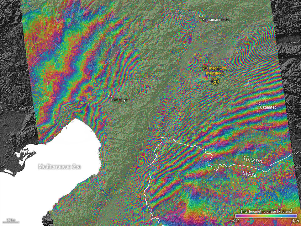
Researchers use a technique known as ‘interferometry’ to compare before-and-after views after an earthquake has hit. In this case, data from Sentinel-1 have been combined to measure the coseismic surface displacement, or changes on the ground, that occurred between the two acquisitions. This leads to an interferogram that shows a colourful interference (or fringe) pattern and allows scientists to quantify surface displacement.
An interferogram, calculated using Sentinel-1 acquisitions on 28 January and 9 February, reveals a large-scale deformation between Maras and Antakya with high gradient fringes and low coherence along the Karasu valley. According to Ziyadin Çakır, from the Department of Geology at Istanbul Technical University, the Sentinel-1 interferogram indicates that it is the East Anatolian Fault that ruptured during the first earthquake. A preliminary analysis also shows up to several metres of fault slip at Earth’s surface.
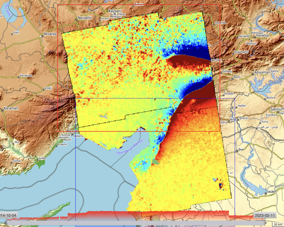
Radar interferograms were also generated using acquisitions from 9 February and 28 January 2023 from the Geohazard Exploitation Platform (GEP). The platform allows experts to process many types of data and it was used to generate different measurements both radar and optical.
Philippe Bally explains, “Sentinel-1 and Sentinel-2 data allow geohazard risk assessment experts to retrieve precise information concerning terrain motion. Given the amplitude of the deformations on the ground over the East Anatolian Fault, different Earth observation processing chains have been used on the Geohazard Exploitation Platform using complementary Earth observation missions.
“These include radar interferometry and pixel offset tracking services using the processor developed by the German Aerospace Research Centre and sub-pixel correlation of optical images such as using the GDM-OPT-ETQ service of ForM@Ter implemented by the CNRS/EOST.”
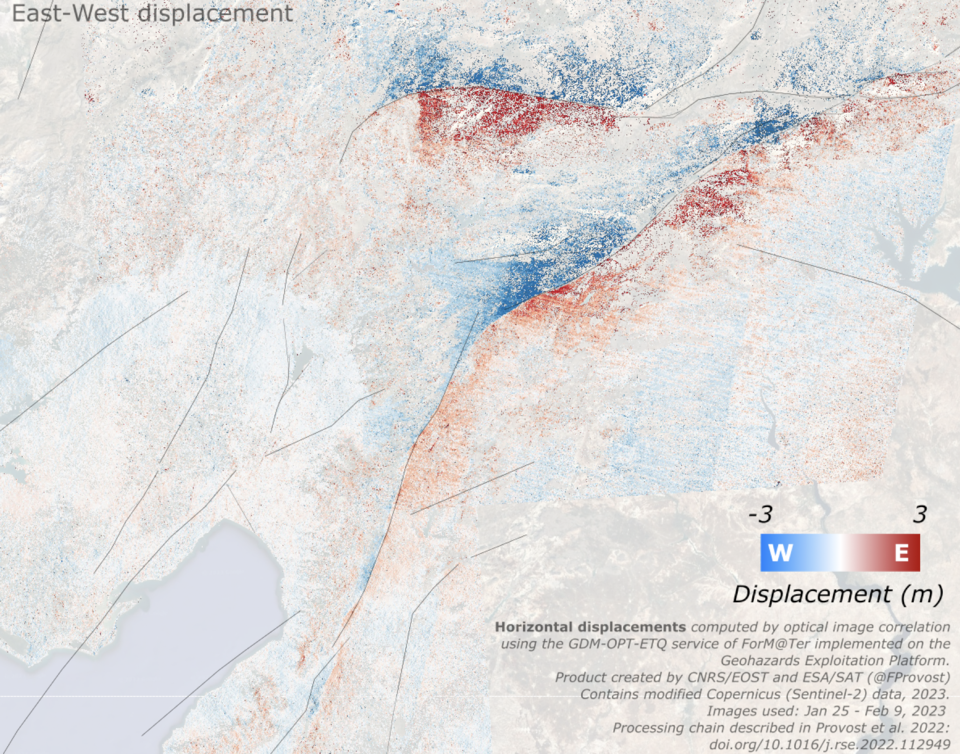
Ziyadin Çakır commented: “Such maps of pixel offset from Sentinel-1 and Sentinel-2 are extremely useful to pinpoint the locations of earthquake surface ruptures, to measure surface slip and to estimate damage distribution that are critical for better understanding this disaster.”
Philippe Bally concluded: “All these techniques contribute to the measurement of earthquake induced terrain deformation. The GEP is accessible to geoscience experts in the context of international collaborations such as the CEOS working group on disasters.”


