Validation workshop offers upbeat assessment of Envisat’s instruments
"We now have the tools to provide many, many good things for European science," summarized Envisat Mission Manager Henri Laur in wrapping up last week’s workshop that reviewed whether the satellite’s 10 advanced sensors operate as billed.
The Envisat Validation Workshop, held 9-13 December at ESA’s ESRIN facility in Frascati, Italy, brought together more than 400 scientists and engineers from Europe’s leading universities and research institutions for a series of instrument-specific analyses of the exhaustive series of tests that have been run on each of Envisat’s sensors since the spacecraft was launched in March.
The workshop participants represented the 200 "principal investigators," or PIs, from the European science community working with ESA to calibrate the Envisat instruments and ensure that the data coming from the sensors match those from other ground-, air- and space-based instruments. This process of calibrating satellite instruments and verifying their accuracy is critical to the delivery of reliable data and the subsequent scientific research based on the information.
Instrument validation teams reviewed each of the Envisat sensors and recommended, as needed, instrument re-calibrations and further modifications to the computer algorithms handling the actual processing of the data as the information is returned to Earth.
“What we try to determine in this process are what modifications are needed before products are released to the scientific community and develop a preliminary list of recommendations for the product finalisation,” said Pascal Lecomte, head of ESA's Sensor Performance and Product Assessment (SPPA) section and chairman for the workshop’s final plenary session.
"It’s not a glamorous part of space research," added a workshop participant. "But it’s a crucial one, if we’re going to trust the data we see from the satellite later on."
In addition to the 200 PIs involved in this "Cal/Val" process for Envisat, a further 250 PIs out of an overall total of over 700 are already involved in the Envisat program.
"Judging from the large number of requests for data, there’s plenty of enthusiasm from Europe’s science community for the Envisat program," Laur said.
Envisat product levels
Of the 73 data products to be distributed on an operational basis from all Envisat instruments, Laur said the workshop's assessment was that most of them are ready for operational delivery of data.
Envisat’s data products are divided into three categories – Level 0, 1 or 2 – depending on the amount of processing needed to transform raw satellite data (Level 0) needed to correct geographical distortions from the satellite’s angle looking down at the Earth (Level 1) to more sophisticated datasets that provide actual measurements of a geographical or physical phenomena (Level 2), for instance, the concentrations of ozone in a region of the atmosphere.
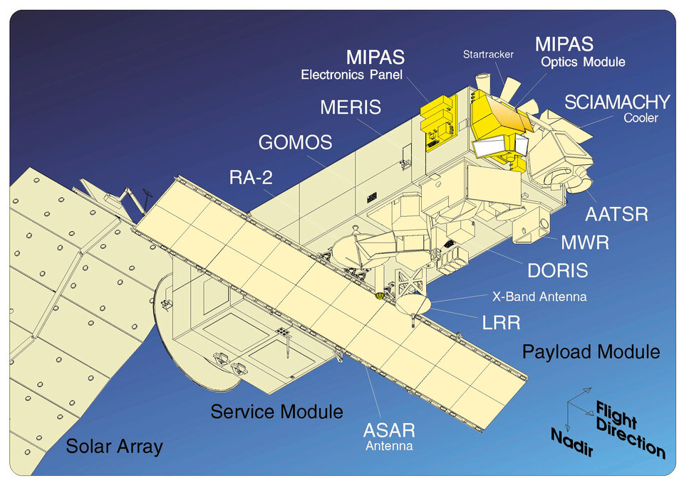
Envisat has been delivering 28 types of Level 1 products from the Advanced Synthetic Aperture Radar (ASAR) since September, together with those from other mature Envisat instruments, such as the Radar Altimeter 2 (RA-2), Laur added.
Early ASAR anomalies have been resolved, pending verification of one final software patch, said Betlem Rosich Tell, ASAR Engineer in ESA's SSPA section. "As of today, all products are to be released," she said. "The overall quality of the instrument is very good."
RA-2 tests use buoys and oil platform
To validate the RA-2 instrument, which can provide measurements of sea and ice heights, tests were conducted comparing data from the sensor against those from coastal buoys of the coast of Spain, reported Mònica Roca, RA-2/MWR System Performance Engineer. Long-term monitoring of the instruments’ performance will be conducted using equipment mounted on an abandoned oil platform near Casablanca in the Mediterranean Sea, and wave height information will also be compared against similar data from ESA’s ERS-2 satellite.
"Performance of the RA-2 has been excellent," Roca said.
Presenting the report from the group examining AATSR that measures land and ocean surface temperatures by scanning at several infrared and visible frequencies, Marianne Edwards of the University of Leicester’s Space Research Centre in the UK, described how sensor data were compared with information from a global network of sea buoys and comparable data from other spacecraft.
"The sensor met accuracy requirements for sea surface temperatures to within plus or minus .3 Kelvins, well within specifications," Edwards said.
Validation work on the instrument will continue in 2003 in other geographic regions, including Australia, the Arctic and the Arabian Sea, she added.
Probably the most novel and innovative of all the instruments on board Envisat is the Scanning Imaging Absorption Spectrometer for Atmospheric Chartography (SCIAMACHY) instrument. Results from Sciamachy show that in its initial operations errors found in Level 1 products related to the instrument calibration "are propagating into Level 2 products," said Ankie Piters, with the Royal Netherlands Meteorologic Institute (KNMI). "Operational products do not meet the required accuracy."
Additional calibration recommended for SCIAMACHY
Piters said that the SCIAMACHY sensor group recommended additional work on calibrating the instrument and additional updates to the algorithms. In spite of the initial drawbacks, she said that the scientific community remains confident that the ambitious targets set for the data from SCIAMACHY will be met. "We hope to do some very nice science with this," she said.
At the meeting’s final session, representatives from other sensor working groups also provided their summaries on validation progress to date, and recommendations for further work, including:
• Medium Resolution Imaging Spectrometer (MERIS)
"MERIS is in very good shape, with very few problems," reported Philippe Goryl, MERIS Engineer in the SSPA section of ESA. Inflight spectral characterisation results showed "unprecedented accuracy," he said, adding that geophysical products including cloud and water vapour, along with cloud optical thickness, need additional statistical analysis. Three validation campaigns were conducted over Berlin in November to cross-check the accuracy of MERIS data against the findings from aircraft-mounted sensors, with a follow-up campaign planned for May.
• Michelson Interferometer for Passive Atmospheric Sounding (MIPAS)
By observing the Earth’s atmosphere in the middle infrared range, the MIPAS sensor can map various trace gases to provide profiles, for instance, of industrial pollution and greenhouse gases for better insights into atmospheric chemistry. MIPAS Level 1 datasets "meet or exceed specifications," reported Herbert Nett, ESA's MIPAS System Analysis Engineer.
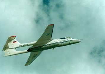
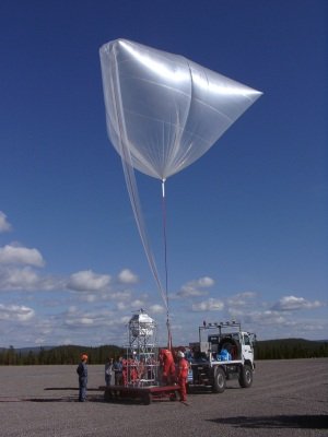
Nett described the series of tests to validate MIPAS and other sensor data through a series of balloon flights that sampled atmospheric gases at the same time Envisat passed over the test area. Comparison of the results showed a "strong correlation between the balloon and MIPAS results," Nett explained.
The MIPAS working group recommended the release of Level 1 products and additional improvements to Level 2 products by February to correct for the affect of cloud cover at altitudes below 20 km, Nett added.

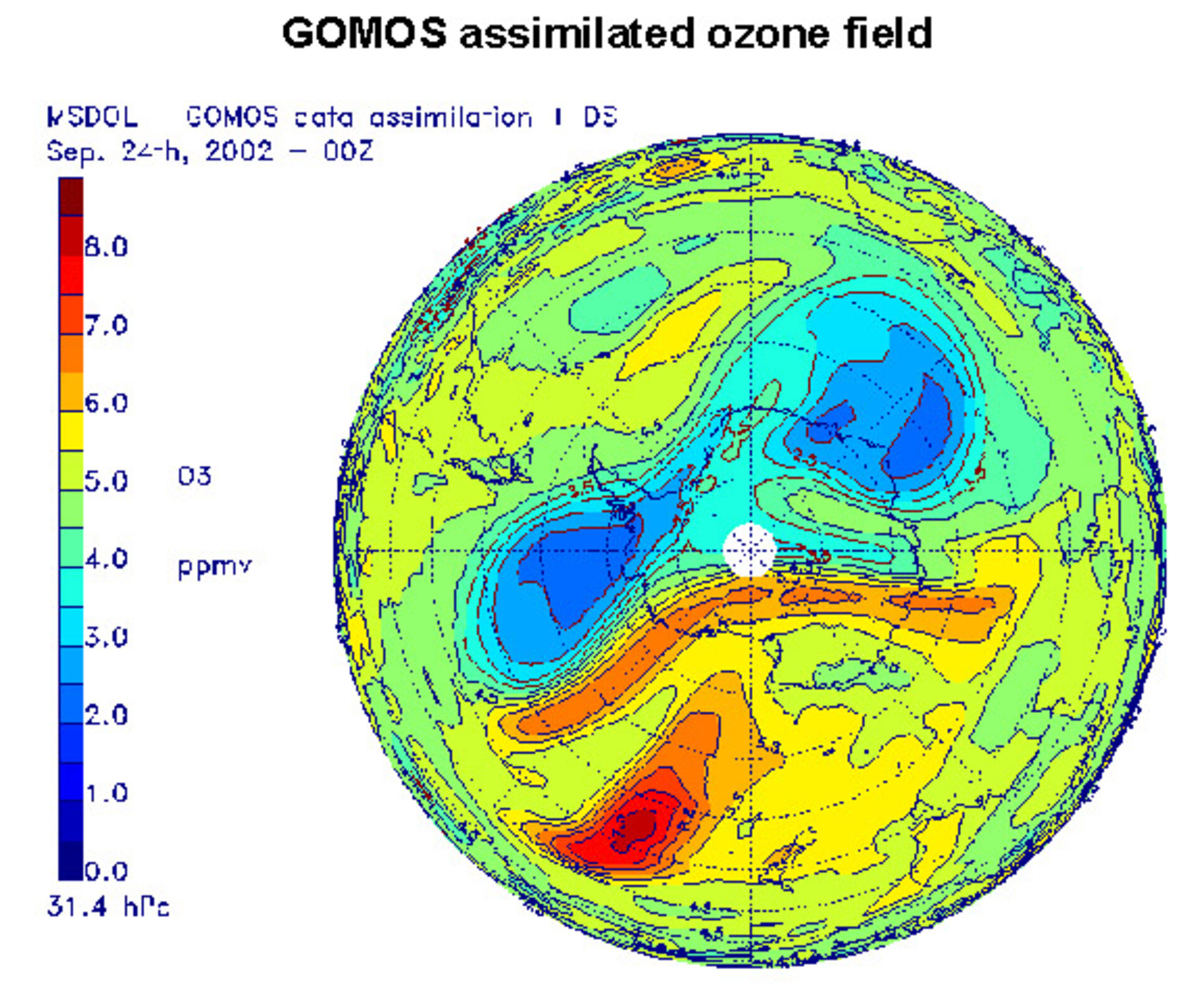
• Global Ozone Monitoring by Occultation of Stars (GOMOS)
Odile Fanton d’Andon with ACRI-ST, a French environmental research and consulting organization, reported that the GOMOS sensor to measure water vapour and ozone levels by tracking starlight through the Earth’s atmosphere. For ozone measurements, Fanton d’Andon said, GOMOS provides an excellent mean profile, with no biases detected compared with lidar measurements, and less than ten percent compared with other data sources. The working group recommended, she added, improvements to the GOMOS algorithms, updated Level 2 products, and continued validation work.
Validation activities to continue through Envisat’s lifetime
Although the main validation phase for Envisat’s instruments will be completed next year, ongoing validation products will continue throughout the lifetime of the Envisat mission,” ESA’s Lecomte told attendees.
"We expect to see continual improvements to the instruments and algorithms,” he said. “We want to give you the best product we can."