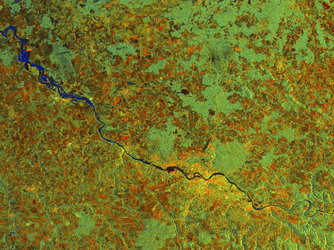
ASAR AP colour composite of China's Nen River in flood
Acquired on 21 July 2005 as part of the Dragon Programme Rapid Flood Mapping activity, this detail from a Envisat Advanced Synthetic Aperture Radar (ASAR) Alternating Polarisation Mode (APM) image shows the flooding Nen River in Heilongjiang Province in northeast China.
APM mode provides simultaneous acquisitions of data in two polarisations with a swath of 100 kilometres spatial resolution of approximately 150 metres. In this colour composite, red represents HV, green HH and blue HV-HH. The water areas are the darkest signatures, with the river to the south being severely flooded, having a width of around 20 kilometres.
Visible as a bright area just east of the Nen River is the city of Qigihar, an important industrial city with a population of 800 000. The land in the vicinity of the Nen River is used for rice and vegetable growing, with the Daqing oil fields located to the east.