

ESA and the COVID-19 pandemic
Over the past six months, COVID-19 has disrupted all of our lives enormously. But throughout the pandemic, ESA has been using its space data, services and technology to support the response effort.
ESA sought expertise from economists, geopoliticians, psychologists, medics, data scientists and others in a series of interactive online seminars that explored how space can help improve life on Earth both during and after the outbreak. The discussions were very fruitful in planning for the future, but ESA's programmes and directorates are already contributing in a variety of ways.
Observing Earth from space
A recent report from the World Food Programme forecasts that the COVID-19 pandemic could push over 130 million additional people into chronic hunger by the end of 2020. The pandemic has caused numerous problems and uncertainties along the food supply chain such as limited labour, transport, cross-border trade and the availability of produce. Earth observation satellites are helping to alleviate the situation by providing crucial information to monitor crop growth and harvesting from space.
Agriculture is just one of the impacts of COVID-19 that can be monitored using the new 'COVID-19 Earth Observation Dashboard', a platform created by NASA, ESA and the Japanese Aerospace Exploration Agency (JAXA). The dashboard allows users to track changes in air and water quality, climate change, economic activity and agriculture to explore and investigate how regional lockdowns and social distancing measures have affected Earth's air, land and water.
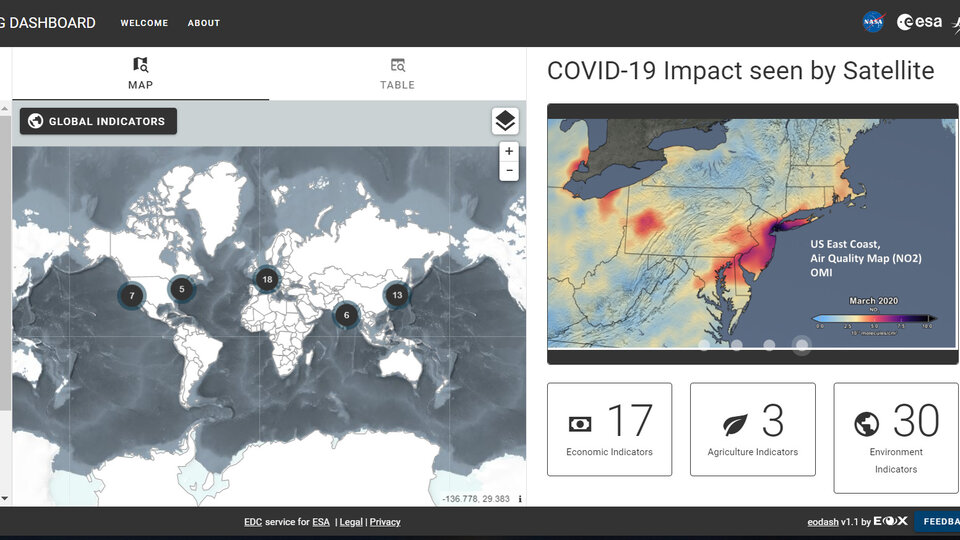
ESA also worked closely with the EU to create the 'Rapid Action Coronavirus Earth observation dashboard'. Launched in June 2020, the platform uses Earth observation satellite data to measure the impact of the coronavirus lockdown and monitor post-lockdown recovery through monitoring key environmental parameters.
With lockdown measures in force across the globe, the pandemic is also affecting aspects of everyday life that may not be so obvious. The drop in commercial flights, for example, has led to fewer measurements for weather forecasts, but fortunately, ESA's Aeolus mission is helping to fill the gap. Meanwhile, Italy's efforts to limit the spread of COVID-19 led to a decrease in boat traffic in Venice’s famous waterways, as captured by the Copernicus Sentinel-2 mission.

To see how Earth-observing missions could be further used to explore the effects of COVID-19, in April ESA issued two new calls for proposals. The aim of the first was to see how satellite data can be used, for example, to map changes around transport networks, commercial ports and heavy industry such as oil refineries. In addition, in coordination with the European Commission ESA called for remote sensing experts, machine learning scientists as well as the interested public to submit ideas on how satellite data could help mitigate the situation for economic sectors such as industry, commerce, transport and agriculture.
Observing changes in air pollution
One well-documented outcome of the COVID-19 lockdown measures is that air quality improved around the world.
The Copernicus Sentinel-5P satellite observed a dramatic reduction in concentrations of nitrogen–released by power plants, industrial facilities and vehicles – in all major Chinese cities between late-January and February. In March, when the pandemic was easing across China and schools, factories, and public spaces began to reopen, Sentinel-5P data shows levels of nitrogen dioxide levels beginning to increase again.
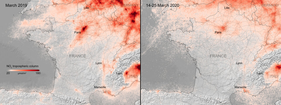
Meanwhile, much of Europe was entering lockdown. Data from Copernicus Sentinel-5P showed reductions in nitrogen dioxide concentrations over several major cities, including Paris, Madrid and Rome. In June, ESA released an online platform that allows users to explore air pollution all over the world, including zooming in on Europe. The maps presented on the platform, which use data from Copernicus Sentinel-5P, show nitrogen dioxide concentrations using a 14-day moving average.
Data from Copernicus Sentinel-5P was also used with data from the GHGSat satellites to investigate hotspots of methane emissions during the COVID-19 pandemic. One of the largest sources of methane emissions is the production of fossil fuels and emissions can be attributed to specific facilities. Interestingly, data showed a substantial increase in methane concentrations in March-April 2020 compared to the same period in 2019. Claus Zehner, ESA's Copernicus Sentinel-5P mission manager explains, "An explanation for this could be that as a result of less demand for gas because of COVID-19, it is burned and vented – leading to higher methane emissions over this area."
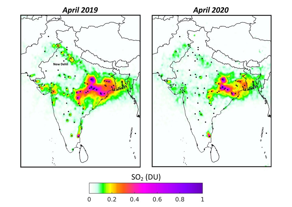
Looking further afield, Copernicus Sentinel-5P data have also been used to monitor sulphur dioxide concentrations over India. In India, emissions of sulphur dioxide have strongly increased over the last ten years, exacerbating haze problems over large parts of the country. However, owing to the COVID-19 pandemic, human and industrial activity dropped considerably since the beginning of its lockdown on 25 March 2020. Scientists produced maps showing that concentrations of the pollutant decreased by around 40% between April 2019 and April 2020.
For more information about the use of Copernicus Sentinel-5P data to monitor air pollution in a world affected by COVID-19, see the in-depth article published by our Earth observation team in September.
Telemedicine on the frontline
It's not only Earth observation satellites that have been supporting the COVID-19 response effort; telecommunications satellites have played their part too.
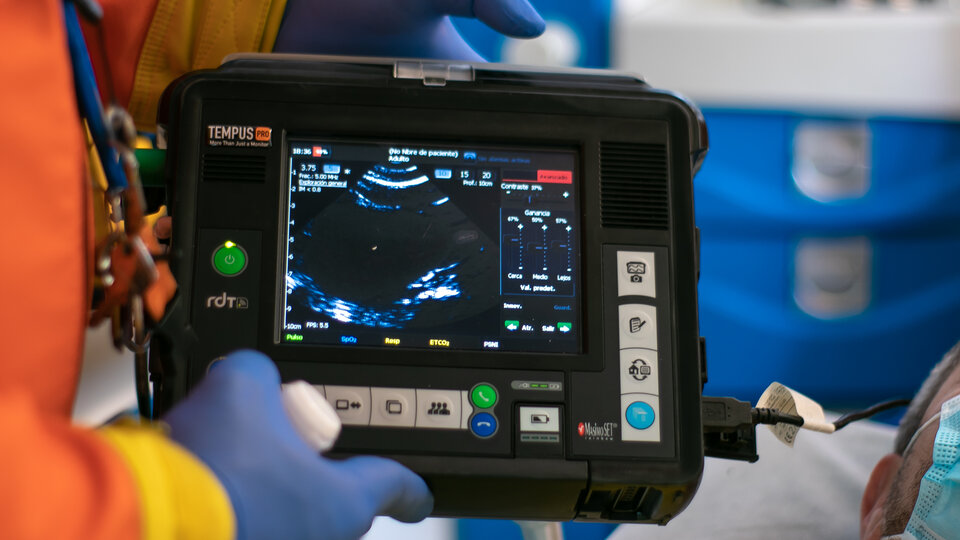
In Barcelona, emergency responders have been using two ESA-supplied telemedicine devices to triage and treat urgent patients. Via a secure satellite link or phone network, the Tempus Pro devices allow operators to quickly check a patient’s vital parameters such as heart rate, blood pressure, respiration rate and temperature, before transmitting these to medical colleagues elsewhere. The two devices are normally used by doctors at ESA's European Astronaut Centre (EAC) to assess and communicate the condition of astronauts when they return to Earth.
Satellite communications also play a part in an ESA-backed mobile field laboratory set up recently in Italy, which is helping the authorities to test thousands of key workers for COVID-19. The laboratory – called B-LiFE – was developed as part of ESA’s Space Solutions programme, which provides funding and business support to hasten the development of new products and services that use space assets.
Funding commercial ideas
On 1 April, ESA launched the "Space in response to COVID-19 outbreak" funding scheme, inviting companies to submit their ideas for deploying and demonstrating services to respond to the emergency that Europe faced and continues to face because of the spread of the coronavirus. More than 130 proposals were made within three weeks, demonstrating the use of space-assets (such as satellite communications, Earth observation, satellite navigation or human spaceflight technologies), integrated with other innovative technologies, to respond to the pandemic. Because of the large quantity of high-quality ideas received, in May, the funding for the scheme quadrupled thanks to the Italian delegation to ESA.

A second initiative was issued in mid-April for space-enabled solutions to strengthen the response to the pandemic of the UK's National Health Service (NHS). A third called for demonstration projects focusing on pre-operational, space-based services in the healthcare and education sectors, to be demonstrated anywhere in Europe.
In April, a free app launched that helps people observe social distancing to slow the spread of coronavirus. Devised by Lanterne, a UK start-up company supported by ESA, the app uses satellite data and artificial intelligence technologies to identify where people are congregating anywhere in the world.
Making the most of our resources
Solar panels aren't the only example of technology transfer being employed to fight the pandemic. 3D printers that are usually used to print special items for astronaut training and test ideas for future spaceflight are proving to be an ideal tool for producing components for face shields.
ESA trainee and member of Spaceship EAC Timon Schild leads the "Advanced Manufacturing" activities of Spaceship EAC. As a mechanical engineer with experience in 3D-printing, Timon identified the opportunity to work with MakerVsVirus and assisted the remote set-up to enable ‘jobless’ printers to be reallocated while EAC is largely closed to training activities.
Navigating a pandemic
Since the outbreak of the coronavirus pandemic, many apps have been developed that use satnav-based location data to monitor the global spread of the virus and to map outbreaks of the COVID-19 disease. Apps making use of satellite navigation are also proving their usefulness by helping people to implement social distancing in queues and other public spaces. ESA’s partner agency, the European Global Navigation Satellite System Agency (GSA). working with the assistance of the European Commission, has put together a repository of such apps, available here.
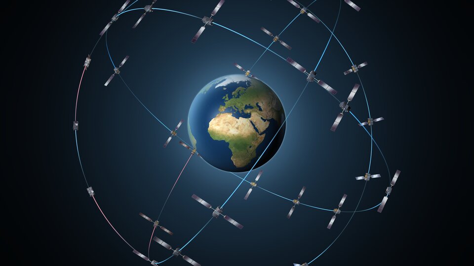
Europe's Galileo, currently embedded in over 1.3 billion smartphones and devices worldwide, is helping to increase satnav accuracy and availability, especially in urban areas. The GSA is also developing its own Galileo-enabled application, Galileo for Green Lane, to monitor and ease the circulation of goods between EU Member States while identifying potential congestion at Green Lane border crossings, and thus ensuring that EU citizens can access the needed supplies of critical goods.
ESA continues to support efforts to tackle COVID-19, taking advantage of the vantage point from space, as well as our advanced technologies and services, to support Earth-based efforts as far as possible. For the latest news keep an eye on esa.int.


