Philippe Martimort: Payload Manager
Philippe Martimort has been the Sentinel-2 Mission Engineering and Payload Manager since 2007 and has been involved in the design and development of Sentinel-2 mission since its inception in 2004. He is responsible for the development and performance verification of the multispectral imager through to the in-orbit commissioning phase. In an interview, Philippe talks about what makes this new instrument so special.
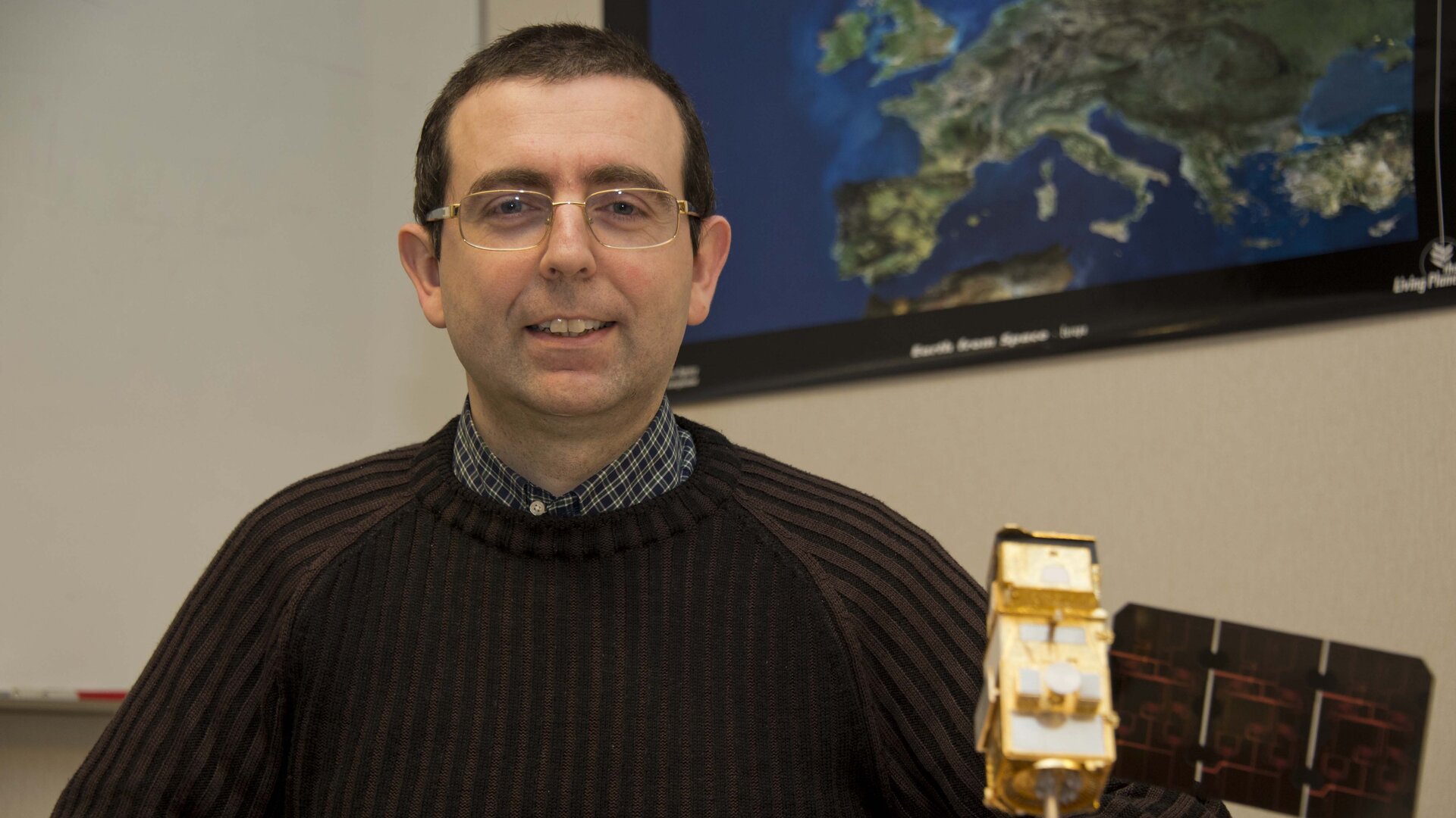
Philippe Martimort, a French national, joined ESA in 2004 as a System Engineer in the Earth Observation Directorate at ESA’s European Space Research and Technology Centre, ESTEC, in the Netherlands. Philippe was responsible for the early design and development phase of the Sentinel-2 mission. Since joining the Sentinel-2 project team in 2007 as Mission Engineering and Payload Manager, Philippe has led the development and performance verification of Sentinel-2’s multispectral imager, and will continue to do so until the end of the commissioning phase.
Prior to joining ESA, Philippe spent the first 10 years of his professional life at the CNES French space agency and in space industry in France, working on Earth observation projects such as Spot, Helios, Pleiades and EarthCARE. Philippe earned his Space Engineering Degree at SUPAERO, which is the Ecole Nationale Supérieure de l’Aéronautique et de l’Espace in Toulouse, France.
ESA: Can you briefly explain what your job involves?
Philippe Martimort
My job involves leading a team of engineers responsible for the development of Sentinel-2’s Multispectral Imager (MSI) throughout the life of the project, from the design to its assembly, integration, test and performance verification on-ground through to in-orbit calibration/validation. This involves many interactions with industry (Airbus Defence and Space and their consortium) that actually build the MSI, ESA colleagues at ESA’s Centre for Earth Observation, ESRIN ,that develop the Payload Data Ground Segment, CNES colleagues that provide image quality support and expertise tools, and NASA for the cross-calibration between Landsat-8 and Sentinel-2 missions.
Over the years, our day-to-day work has evolved significantly. It started with the set-up of the industrial consortium that involved thorough negotiations with the MSI prime contractor and all the sub-contractors across Europe. Then the focus was on the consolidation of the MSI design and verification approach, whereby innovative testing methods were introduced, e.g. for straylight characterisation. This led to the intensive phase of follow up of the integration and test of the MSI, when real hardware and software issues occurred and had to be adequately and timely resolved. This all culminated in the preparation of the in-orbit calibration/validation phase, including the development and validation of a wide range of image quality and processing tools.
All in all, this meant I had to be an ‘orchestra leader’ to maintain a cohesive and motivated team that focussed on achieving of the mission objectives, but also to be a ‘fire fighter’ to identify any problems early and to prioritise issues so that they could be resolved properly in a timely fashion.
ESA: With 13 spectral bands, Sentinel-2’s imager is the most advanced of its kind, why is the number of bands important?
Philippe Martimort
With a total of 13 multispectral bands, Sentinel-2 will provide a breakthrough compared to Landsat-8 and SPOT-6/-7 that have eight and four multispectral bands, respectively.
Each spectral band provides access to specific features of the ground, therefore the more spectral bands you have the more features you can detect on Earth’s surface. The 13 spectral bands of the MSI span from the visible (VIS) and the near-infrared (NIR) to the shortwave infrared (SWIR), at different spatial resolutions on the ground ranging from 10 to 60 m.
In particular, the infrared bands offer access to features that cannot be detected by the human eye. Some are useful for distinguishing between clouds and snow & ice (that otherwise appear white in the visible spectrum), and for identifying features of the ground, in particular for vegetation that exhibits significant variations in its reflectance in the infrared depending on its geometrical and chemical structure and on its development level.
The four bands at 10 m resolution ensure continuity with SPOT-4 and -5 and address the user requirements for basic land-cover classification. The six bands at 20 m resolution address user requirements for enhanced land-cover classification and for the retrieval of geophysical parameters. The three bands at 60 m are dedicated to atmospheric corrections and cirrus cloud screening, thereby playing an important role to discriminate real variations of Earth’s surface reflectance from variations of the atmospheric conditions.
ESA: It’s also the first satellite to use ‘red-edge’ bands, what are these and what will they be used for?
Philippe Martimort
Sentinel-2 will be the first optical Earth observation mission of its kind to include three bands in the ‘red edge’ part of the spectrum, between 700 and 800 nm, that provide key information on vegetation development status. Indeed, the reflectance of vegetation significantly varies in this part of the spectrum, depending in particular on the chlorophyll concentration in vegetation, as demonstrated with previous optical missions such as MERIS on Envisat. Sentinel-2 will be the first mission to provide access to this detailed level of information on vegetation at high resolution (20 m, compared to 300 m with MERIS). Combined with Sentinel-2’s other spectral bands the three red edge bands will be valuable to identify subtle variations in vegetation status and to infer potential stress (e.g. signs of drought or diseases) that could adversely impact the crop yield. Depending on the findings, this may be mitigated by improving irrigation practices or by addressing issues of pests. If no remedy can be found, a low crop yield could be forecasted, which could help humanitarian aid organisations address starvation in developing countries.
ESA: The imager also has particularly large swath width of 290 km, how does this improve vegetation monitoring?
Philippe Martimort
Thanks to the MSI large swath width of 290 km, the Sentinel-2 mission with two satellites in orbit will provide a frequent revisit time of five days over all land and coastal areas on a worldwide basis. This represents a step forward compared to missions such as Landsat-8 (16 day revisit time) and SPOT (26 day revisit time). Furthermore, Sentinel-2 will be the first optical high-resolution mission to systematically cover all land and coastal areas from the North of Greenland down to Southern America. This high temporal sampling frequency combined with a systematic worldwide coverage will allow to changes in vegetation to be detected early anywhere on Earth. This is especially important during the growing season that involves rapid changes of vegetation cover in a short time frame (growing season can last only a few months for some crops). The high temporal sampling of five days that Sentinel-2 brings will maximise the likelihood of acquiring one or several cloud-free images during the growing season and therefore subtle changes in the vegetation growth can be detected.
ESA: What have been the most rewarding aspects of working on the mission?
Philippe Martimort
The most rewarding aspect of working on Sentinel-2 has contributing to the development of an operational mission, that will make a step forward in the monitoring of our Earth’s environment and that will be valuable for all European citizens and for mankind at large. Furthermore, I had the opportunity to work on Sentinel-2 from the very inception of the project, when Sentinel-2 was just a name, throughout the manufacturing, assembly and testing of the satellite and up to the forthcoming launch and in-orbit commissioning phase. After 11 years spent on Sentinel-2, I look forward to receiving and processing the first Sentinel-2 MSI images that will bring a new vision on our dear planet Earth. This will be the crowning achievements of joint team efforts deployed at ESA (ESTEC, ESOC and ESRIN), industry and other partner agencies around the world.
Editor's note:
This is one in a series of interviews with a few of the key people that are involved in the Sentinel-2 mission. Please check back as further interviews will be added to over the coming weeks.