
Earth from Space: Korean Peninsula
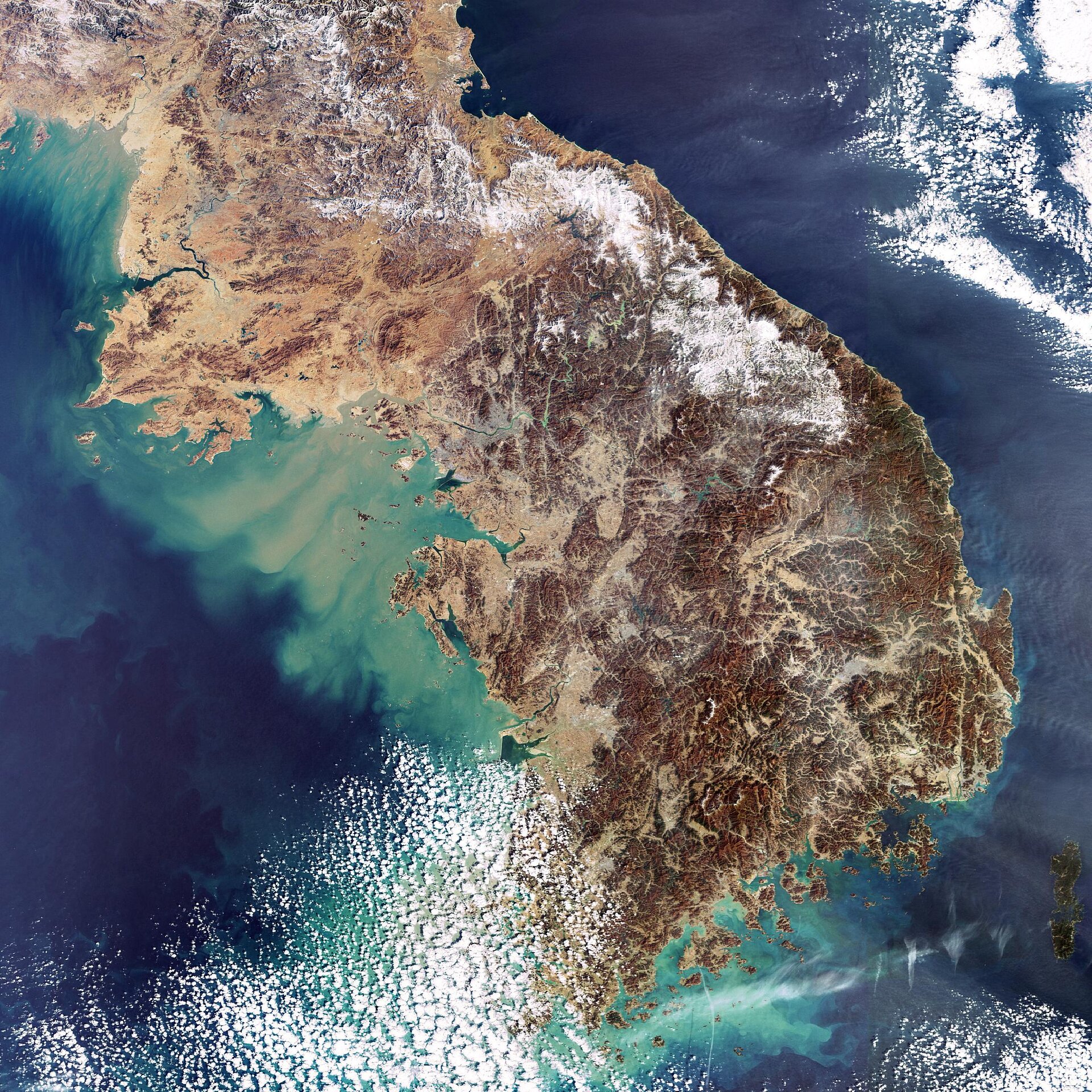
The Korean Peninsula in East Asia is highlighted in this Envisat image. The 966-km long peninsula is located between the Sea of Japan (East Sea) to the east and the Yellow Sea to the west and is bounded by the Korea Strait to the south.
The peninsula is divided into two countries – the Democratic People's Republic of Korea (North Korea) and the Republic of Korea (South Korea). North Korea, which covers about 55 percent of the peninsula, is bordered by China and Russia to the north. The border occurs below the area that juts out into the Yellow Sea on the west side.
North Korea (120,538 sq km) is divided into nine provinces, with Pyongyang as the capital. Pyongyang is located on the Taedong River (the dark blue body of water seen emptying into the Yellow Sea in the upper left hand of the image).
The capital of South Korea (98,477 sq km) is Seoul (seen in light green just off the western coast in the northwest of the country). Seoul, located some 50 km south of the North Korean border on the Han River, hosted the 1988 Olympic Games and served as one of the host cities of the 2002 FIFA World Cup.
Busan, also referred to as Pusan, is the largest port city in South Korea (located on the southeast) and the second largest metropolis, after Seoul. Busan, which hosted the 2002 Asian Games and served as one of the host cities for the 2002 FIFA World Cup, has officially announced its bid to host the 2020 Summer Olympic Games.
As visible in the image, the peninsula is largely mountainous and rocky, making less than 20 percent of the land arable. Because the waters around Korea provide excellent fishing grounds, fish is the peninsula’s chief source of protein.
Named for the yellowish sand that colours its water, the Yellow Sea experiences fluctuations in climate due to winter and summer Monsoon conditions, with the sea surface temperature changing as much as 10 degrees Celsius. The Yellow Sea is one of the largest shallow areas of continental shelf in the world with an average depth of 44 metres and a maximum depth of 152 metres. It is 870 kilometres long and 556 kilometres wide.
The Sea of Japan (East Sea) is an enclosed arm of the Pacific Ocean that is bounded by Japan and Sakhalin Island to the east and Russia and Korea to the west. It has a mean depth of 1752 metres and a maximum depth of 3742 metres, with the northern and southern portions being more shallow and important fishing areas.
This image was acquired by Envisat's Medium Resolution Imaging Spectrometer (MERIS) instrument on 11 February 2007, working in Full Resolution mode to provide a spatial resolution of 300 metres.

