
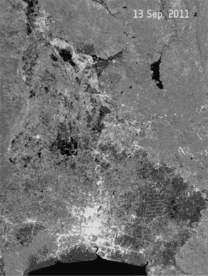
Earth from Space: Thailand floods
The dark areas in these five Envisat radar images taken over Thailand from mid-September to early November show waters from the Chao Phraya River flooding the surrounding land and flowing south towards the capital, Bangkok.
Since July, Thailand’s worst flooding in half a century has claimed over 500 lives. It has pushed tens of thousands of people from their homes and destroyed millions of hectares of land in over 50 provinces.
Over the period covered by these images, water spread over nearly a third of the country’s provinces. The historical Ayutthaya city – a UNESCO World heritage site – was inundated and barriers protecting industrial estates failed.
Water has since advanced into parts of the capital and continues to threaten key business and shopping districts in central Bangkok.
Surrounded by the Chao Phraya River basin, Bangkok sits on a swamp about two metres above sea level. Along with the plentiful canals that snake through the city, this makes it prone to flooding during the monsoon season.

