
Optical Multisensor Radiance Data Fusion Techniques (OPTIRAD)
| Programme: | TRP Workplan | Achieved TRL: | 4 |
| Reference: | T126-305GT | Closure: | 2016 |
| Contractor(s): | Assimila Ltd (GB), UCL (GB), FastOpt (GB), RAL Space (GB), VU Amsterdam (NL) | ||
Land modelers increasingly need observations to better constrain their model simulations. Data can be used in various ways according to the model application, from validation of representation of processes, initialisation of climate prediction, up to constraining inversion scheme for carbon cycle studies. One way to address this issue is to perform joint retrieval of EO-based land products from low-level EO data. Hence, the idea of this project is to further develop and validate the OPTIRAD Collaborative Research Environment (CRE) framework, covering all the necessary activities to demonstrate the operation of the software (the OPTIRAD toolbox). This is done using real data and comparing the obtained results with the in-situ measurements and with similar data obtained through other processing techniques.
Such a development and validation activity demonstrates the achievement of the main scientific aims of OPTIRAD, in terms of the functionality added to the precursor EO-LDAS system, namely:
- The addition of capabilities to process passive microwave data;
- The ability to perform joint retrievals using optical and microwave data;
- The addition of a radiative transfer model suitable for forest targets;
- The operation of spatial and temporal regularisation in a typical agricultural test case;
- The calculation of uncertainties associated with land surface variables.
Objectives
The objective of the project is therefore to expand the capability of the OPTIRAD CRE by:
- Integrating new RTM capabilities;
- Optimising the CRE software environment for data-intensive scalable cloud-type computing;
- Developing a portfolio of use cases enabling users to verify CRE functionalities and validate the generated data products.
Two additional objectives have also been pursued:
- Speeding up the processing using Gaussian Process Emulators;
- Implement and deploying the OPTIRAD software in a shared research environment in UK, the Climate, Environment and Monitoring from Space (CEMS) facility.
The main results of the scientific validation are as follows.
Achievements and status
The OPTIRAD prototype resulting from the project permitted to demonstrate the capabilities to:
- Perform retrievals using synergy of passive microwave and optical sensors;
- Use the forest radiative transfer model (ACRMF) to retrieve forest canopy parameters;
- Perform spatial and temporal regularisation;
- Estimate uncertainties;
- Speed up the processing using Gaussian Process Emulators;
- Implement the software in a shared research environment (CEMS).
More details are provided below.
Passive microwave and optical synergy
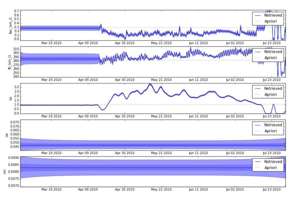
Retrievals were made of LAI and soil moisture over an experimental farm site in Germany, using both optical data, passive microwave data, and the two datasets combined. Using optical data alone, only vegetation parameters could be retrieved and adjustment of the uncertainty values for the input data (which are not specified in the data) allowed successful retrievals of LAI. Using microwave data only, soil moisture, temperature and LAI were retrieved with varying results. Both temperature and LAI showed good agreement with the ground measurements with high correlations and low errors. In contrast the retrieval results of soil moisture was not as good due to 1) a too high temporal regularization in the case of sudden precipitation events, and 2) a sampling depth difference between the ground-observation and the L-band microwave radiometer. Using both optical and microwave data after adjusting the uncertainties of the optical data, the total data-assimilation results improved compared to the scenarios using only one dataset. This is a very promising result for this novel approach.
Forest RT model
The forest radiative transfer model (ACRMF) was used to retrieve forest canopy parameters over a test site in Estonia using MODIS data. Results were compared with those from the simpler SAIL model. For simple cases only considering LAI, the SAIL model performed slightly better possibly due to having fewer parameters to solve for than the ACRMF model. Despite this, in scenarios where parameters related to canopy structure (which are not present in SAIL, such as clumping) were retrieved, inversions using ACRMF resulted in inferences on these structural parameters that are consistent with our expectations.
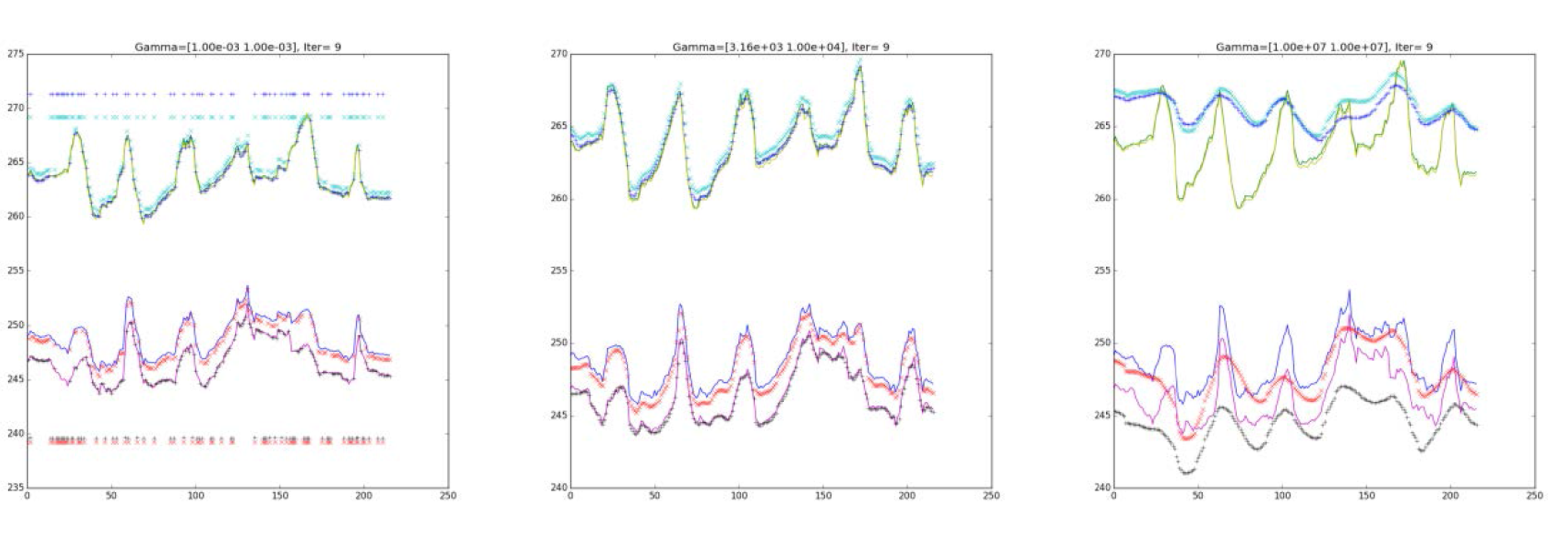
Spatial / Temporal Regularisation
The OPTIRAD toolkit was used to perform retrievals under a number of scenarios, using optical (SPOT5) data from a JECAM test site in the Ukraine. All of the results suffered from a relative sparseness of in situ data and a relatively limited set of crop dynamics during the period for which frequent EO data were available. In a scenario with no spatial or temporal regularisation (i.e. a single retrieval with no assimilation) the results were poor, with a large overestimation of LAI, which gets worse with increasing LAI. The results using only spatial regularisation are a very modest improvement on the single pixel results. Fixing all parameters and only estimating LAI on single images (using spatial regularisation) results in poor results, while adding leaf chlorophyll and leaf water to the inversion improved the results. A reason for this is that solving for leaf water now has an effect on the SWIR reflectance, where LAI is also an important control on reflectance. Fitting to the SWIR in effect limits the ranges of possible LAI values that are acceptable for fitting the other bands. Best results were obtained in the third scenario with the sequential solution for LAI only. For the early part of the season, we see that the LAI over-estimation was mitigated in comparison with the previous cases.
Uncertainties
A test case that had been processed using the variational DA scheme in OPTIRAD was re-evaluated using an alternative method of estimating uncertainties, and one that makes no assumptions on the nature of the posterior distribution. A Markov Chain Monte Carlo (MCMC) technique was used to estimate the full posterior distribution and compare this with the results obtained from the variational version. The results showed a very good correspondence between both distributions, suggesting that the variational approach (a computationally simpler approach) is appropriate for these problems.
Benefits
All the technical advances in OPTIRAD have been demonstrated, albeit with varying levels of success. The system retrieves a rich set of parameters and is designed to output temporally continuous results.
Next steps
There are few (if any) field sites where multi-parameter (ie beyond LAI) data are collected with good spatial and temporal sampling (detailed measurements tend to be one-off campaigns). This kind of fieldwork is expensive and time consuming, but will be essential for future validation of multi-parameter, multi-temporal schemes like OPTIRAD.