|
Izmit earthquake - Introduction
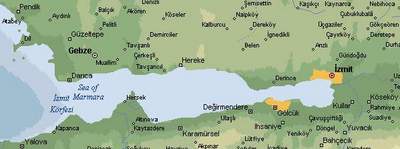
The earthquake's epicentre was identified as being based between Izmit and Bursa, about 100 km east of Istanbul, where an oil refinery caught fire. High casualty figures were reported not only in Golcuk, but also in the towns of Derince and Darica, both situated to the west of Izmit. The large town of Adapazari, northeast of Sapanca Lake, was severely damaged by the quake too. A few hours after the event, the death toll had risen significantly, as the extent of the damage was realised and communications with towns and villages cut off by the quake were resumed. On 18 August, rescue units were busy removing debris, whilst firemen had to fight a raging fire at the Izmit oil refinery, the largest in Turkey. Aircraft dropped chemical flame retardant onto the blaze, that threatened the entire facility. Had the flames not been contained immediately, the risk of an explosion would have been very high. In Turkey, four days after the event, the death toll had risen to more than l0,000, with 45,000 reported as injured, and thousands of people still missing. Two years later, the experts were still analysing what happened and assessing the damage. Their main question was: would such a high death toll be avoidable in future quakes? This and other questions remain unanswered. One of the most important factors to investigate is the type of material used to build those houses that were most seriously damaged or destroyed. A useful overview of the situation is provided by satellites orbiting over the area during the catastrophe. Their imagery can complement the information collected on the ground. It can be used to derive an up-to-date land cover map and, if the data are acquired immediately after the event, to detect fires. An assessment of the damaged area is also possible by comparing very high resolution images taken immediately before and after an earthquake.
In addition, a radar interferometric technique that can be applied to space data allows an area over a 100 x 100 km to be assessed in terms of surface displacement (caused by the earthquake) to an accuracy of only a few millimetres. One may infer that the larger such displacement is, the more significant the damage to buildings will be. Last update: 17 April 2013
| ||||||||||||||||||||||||||||||||||||