
Exercise 3: Multitemporal Change Detection and Monitoring - continued

You have to consider 2 things:
1) Due to constantly changing atmospheric and vegetation conditions (e.g. vegetation succession after lava flows), the DN values for land cover are different in every image. There are some pixels classified as lava in one image but not in another, especially in the south-west of the volcanoes. Classification results should be further improved by ground truthing to verify the training fields, increasing the number of training fields, and increasing the number of classes.
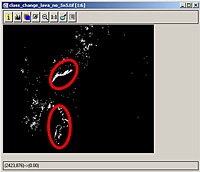 | |
Change detection result
| |
2) The volcanic plume covered parts of the 2001 Nyiragongo lava. There are holes in the 2001 lava stream in this change image. The result can be further enhanced with the 2003-01-15 image, which, despite its bad atmospheric conditions and cloudiness, shows all the lava stream of 2001 (see visual interpretation).
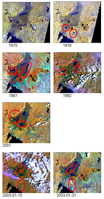 |
Band combination 4-5-3 of Landsat images
|
So far we have looked at images of the years 1987, 2001 and 2003. Thanks to Landsat, we have imagery dating back to the 1970s.
File > Open FCCs (preferably 4-3-2) of the images ny_landsat_1975.tif and ny_landsat_1978.tif. You will see that Landsat-2 had different spectral bands than Landsat-5 and Landsat-7.
File > Open a FCC (preferably 4-5-3) of the images of ny_landsat_1987.tif , ny_landsat_1992.tif, and the 2001 and 2 images of 2003 that we studied before.
3. Write a short text about the visual change detection and the lava flows that occurred at the two volcanoes. Find out when and where the major eruptions occurred (refer to the Global Volcanism Program website). The screenshots will help you.
Last update: 17 April 2013
| |
Nyiragongo and Nyamuragira
| | • | Introduction (http://www.esa.int/SPECIALS/Eduspace_Disasters_EN/SEMDGLNSNNG_0.html) | |
Change detection and hazard assessment
| | • | Worksheet introduction (http://www.esa.int/SPECIALS/Eduspace_Disasters_EN/SEM5NUMSNNG_0.html) | | | • | Exercise 1: Exploring and learning about the volcano (http://www.esa.int/SPECIALS/Eduspace_Disasters_EN/SEMV2MNSNNG_0.html) | | | • | Exercise 2: Lava Detection using Supervised Classification (http://www.esa.int/SPECIALS/Eduspace_Disasters_EN/SEM1LSNSNNG_0.html) | | | • | Exercise 3: Multitemporal Change Detection and Monitoring (http://www.esa.int/SPECIALS/Eduspace_Disasters_EN/SEM8XTNSNNG_0.html) | |
Eduspace - Download
| | • | Nyiragongo_Landsat.zip (http://esamultimedia.esa.int/docs/eduspace/Volcanoes_Exercise_Data_3.zip) | |
Eduspace - Software
| | • | LEOWorks 3 (http://esamultimedia.esa.int/multimedia/LEOWorks3.exe) | | | • | LEOWorks 3 Tutorial (http://esamultimedia.esa.int/multimedia/eduspace/leoworks3-tutorial.pdf) | |
|
