ESAEducationAccueilMétéo et climatChangement globalLes catatastrophes naturelles
   
Inondations
Thessalonique (Grèce)
Tremblements de terre
IntroductionTremblement de terre d'Izmit
Ouragans
Ondes de tempêteL'ouragan Katrina
Volcans
IntroductionCeinture volcanique andineEtnaNyiragongo et Nyamuragira
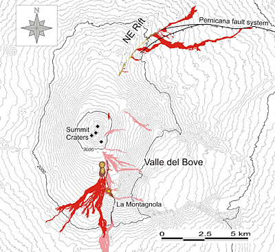


Article Images
Exercice 3: Détection de la lave : cartes et images des événements - suite
 
 
  Changements entre 1999 et 2003
 
Download:
 HI-RES JPEG (Size: 339 kb)
A visual change detection is performed between the Landsat images of 1999 and those of 2003. A region in the south-west and north-east of the summit has been used as an example.

Credits: USGS
 
 
Download:
 HI-RES JPEG (Size: 1001 kb)
The map of the lava flows emitted during the 2002-2003 eruption (shown in red), based in part on post-eruption surveys of the lava fields (much of these carried out by staff of the Catania section of the Istituto Nazionale di Geofisica e Vulcanologia). Pyroclastic cones are shown in dark brown color, and eruptive vents in yellow. Lava flowing out during the July-August 2001 eruption are shown in pink for comparison.

Credits: Italy’s Volcanoes (http://boris.vulcanoetna.it)


Etna
Introduction
Détection des changements et évaluation des dangers
Feuille de travailExercice 1 : Explorer le volcanExercice 2 : Interprétation visuelle au moyen de photographies terrestresExercice 3: Détection de la lave : cartes et images des événementsExercice 4 : Évaluation des dangers : l'utilité du SIG
Eduspace - Télécharger
Etna_Landsat_GIS.zip
Eduspace - Logiciels
LEOWorks 3LEOWorks 3 Tutorial


   Copyright 2000 - 2014 © European Space Agency. All rights reserved.