| | | | |
 |
|
Inondazioni Salonicco (Grecia)Terremoti IntroduzioneTerremoto di IzmitUragani MareggiateL'uragano KatrinaVulcani IntroduzioneCintura vulcanica andinaEtnaNyiragongo e Nyamuragira
| | | | | | | | Article Images |  |
Esercizio 3: Rilevamento lava - immagini e mappe della crisi - 2a parte
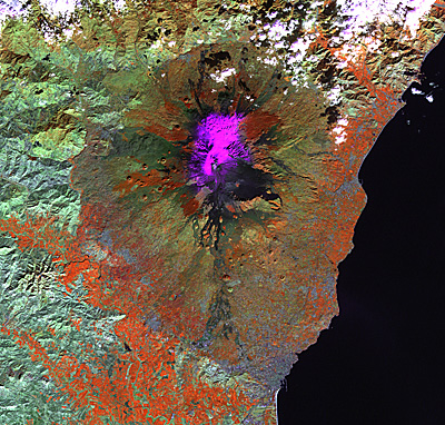
| The new lava stream of Mount Etna's 2001 eruption is visible in the FCC 4-5-3. At this stage most of the lava has already spread (but not all, the eruption lasted approximately until 9 August). Many dark coloured lava streams can be seen.
Credits: USGS | |  |  | |
| | | | | The new lava stream of the Mount Etna's 2001 eruption is visible in the band 6 image. At this stage, most of the lava has already spread (but not all, the eruption lasted until 9 August). The hot lava is still visible in band 6 (hot = white) although it is not distinguishable from others in mid-IR. In the 4-5-3 combination, many dark coloured lava streams can be seen, but only in band 6 can the new one be identified and distinguished from the other ones. Furthermore, the snow is clearly seen (cold = dark).
Credits: USGS | | | | |
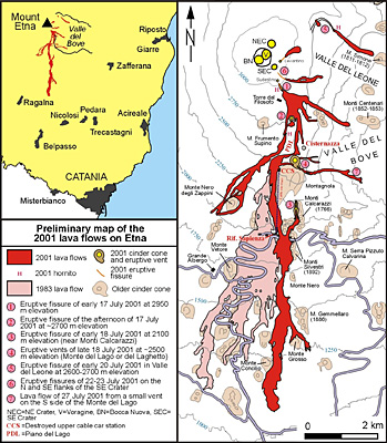
| | | | | Lava map of Etna's July-August 2001 eruption showing lava flows, fissures, and related features. In light pink, the 1983 lava flow field is displayed for comparison. The legend is also linked to numbers near the vents and fissures, as a way to indicate the sequence of activity. The sketch map is preliminary; it is a composite based on both fieldwork by Behnke and others, and already available maps appearing on the web, including those on the site of INGV-Sezione di Catania.
Credits: Boris Behnke and Marco Neri, INGV (Global Volcanism Program, http://www.volcano.si.edu/) | | | | |
| |
| | Etna IntroduzioneRilevamento dei cambiamenti e valutazione del rischio Scheda di lavoroEsercizio 1: Esplorazione del vulcanoEsercizio 2 : Interpretazione visiva tramite fotografie terrestriEsercizio 3: Rilevamento lava - immagini e mappe della crisiEsercizio 4: Determinazione dei rischi. Il GIS può aiutarti!Eduspace - Download Etna_Landsat_GIS.zipEduspace - Software LEOWorks 3LEOWorks 3 Tutorial
|