
|
Exercise 2 - Guide the icebreaker through the ice using images and maps
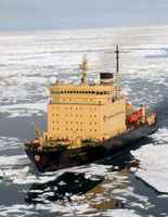
Approaching the coast has to be done cautiously. Land fall might be equally critical (see photo of the Zhong Shan Station). From the ship's bridge, visibility is limited, and even if a helicopter was available for ice surveying, this would be costly, and due to the bad weather, perhaps even impossible.
As you can imagine, the safety and success of the expedition are in your hands!
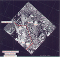
What the captain of the ship would need is a route through the ice and a disembarking point. This means that you would have to provide him with waypoints (positions) and headings in degrees between these waypoints. To do this, you have to interpret the image and trace a line avoiding the floes, following the leads (ice free waters). In every turning point, that is in every change of the travelling direction of the ship, you would have to read the new heading, that is the direction in which the ship has to continue to hit the next waypoint.
The radar image we have was acquired on 21 November 2002. We could have had a similar situation in 2003 during the cruise. We also have a quicklook of an optical image from MERIS, another instrument onboard Envisat.
You can find information on the ASAR image acquired on 21 November 2002 by clicking on the link on the right.
Last update: 18 April 2013
| ||||||||||||||||||||||||||||||||||||||||||||||||||||||||||||||||||||||||||||||||||||||||||||||||