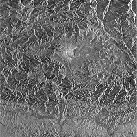
Kathmandu Valley with radar image


ENVISAT ASAR image of the Kathmandu valley
 
Envisat ASAR image of the Kathmandu valley - Click to enlarge and download
 
 
Radar instruments are side-looking, active systems, that transmit and receive microwaves. This means they are capable of acquiring images in all types of weather conditions, and even at night.

They are based on the measurement of distances and the strength of pulses that are scattered back from the Earth's surface. Hills and mountains therefore appear distorted. Most human-made features like houses appear very bright. Forests are also displayed brightly, because the reflecting leaves and branches present a rough surface with a strong level of reflection. On the other hand, highways, runways and bare fields and grassland have smooth surfaces and appear dark.

By turning the image 90 degrees counter-clockwise the topography can be seen better.
 
 
Image Technical Information:

  • Instrument: Envisat Advanced Synthetic Aperture Radar (ASAR), Image Swath 3, Polarisation VV
  • Date of Acquisition: 14 August 2003
  • Orbit Number: 7602 (descending)
  • Scale: 1 : 500,000, 1 cm equals 5 km (if printed unmodified in A4)
  • Coordinates:
    • NW Lat/Long: N 28.10 / E 85.01
    • NE Lat/Long: N 28.01 / E 85.51
    • SW Lat/Long: N 27.08 / E 85.38
    • SE Lat/Long: N 27.17 / E 84.49


Goal: Analysis of the geomorphology and interpretation of a radar image.

Map the different geological units with the help of an overlaid transparency, mainly:

1. Forested plain of the Terai,
2. the Siwaliks (three different sub-units),
3. the Mahabharat,
4. the Kathmandu Valley,
5. the Higher Himalayas.

Map the main rivers (Ganga and Indrawati) that are visible in the image. In particular, follow the Bagmati River carefully from its source North of Kathmandu across all the Southern mountain chains until it reaches the Terai, near the lower right hand corner of the image.

Find features of human construction, such as cities (e.g. Kathmandu, Bhaktapur, Dhulikhel, Trishuli Bazar, Hetauda and Simra). Also look for airports and roads. Mark them on the transparency and name them.

In your group, discuss the unusual image geometry. Radar always acquires data in a side-looking manner. The satellite travels North-North-East to South-South-West, 'looking' to its right-hand side. From which side was the scene 'illuminated' by the radar beam? Also try to explain the greatly foreshortened illuminated mountain slopes and the elongated shadowed (dark) slopes.

Draw up a list of advantages and disadvantages of radar images versus optical/infrared satellite images.


Acrobat Reader is required to view and print the PDF. Download Adobe Acrobat for free.


Last update: 16 April 2013


Kathmandu

 •  Introduction (http://www.esa.int/SPECIALS/Eduspace_Global_EN/SEMF1QTTGOF_0.html)
 •  Background (http://www.esa.int/SPECIALS/Eduspace_Global_EN/SEMR3QTTGOF_0.html)

Exercises

 •  Worksheet introduction (http://www.esa.int/SPECIALS/Eduspace_Global_EN/SEME7QTTGOF_0.html)
 •  Kathmandu - Now and then with optical images (http://www.esa.int/SPECIALS/Eduspace_Global_EN/SEMCFQTTGOF_0.html)
 •  Kathmandu Valley - General overview with optical images (http://www.esa.int/SPECIALS/Eduspace_Global_EN/SEMSQRTTGOF_0.html)
 •  Kathmandu - Now and then - Urban detection with optical images (http://www.esa.int/SPECIALS/Eduspace_Global_EN/SEM78STTGOF_0.html)

Links

 •  References (http://www.esa.int/SPECIALS/Eduspace_Global_EN/SEMEJ4WPXPF_0.html)
 •  ESA's Proba website (http://www.esa.int/SPECIALS/Proba_web_site/index.html)
 •  The Landsat programme (http://landsat.gsfc.nasa.gov/)
 •  What is remote sensing? (http://www.esa.int/SPECIALS/Eduspace_EN/SEMF9R3Z2OF_0.html)

Eduspace - Software

 •  LEOWorks 3 (http://esamultimedia.esa.int/multimedia/LEOWorks3.exe)
 •  ArcExplorer (http://esamultimedia.esa.int/multimedia/eduspace/ae2setup.zip)

Eduspace - Download

 •  kathmandu.zip (http://esamultimedia.esa.int/multimedia/eduspace/kathmandu.zip)
 •  Technical information about Landsat bands (PDF) (http://esamultimedia.esa.int/docs/eduspace/Technical_data_LANDSAT_bands.pdf)
 •  Kathmandu_Proba.zip (http://esamultimedia.esa.int/docs/eduspace/Kathmandu_Proba_20040505.zip)