|
Cairo - Then and Now
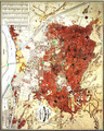
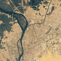
Cities like Cairo are subject to change. Former industrial areas are recreational areas today, and agricultural land has become densely built-up areas. Even today, very old city structures can be found. Just think of the historic part of your own town. The changes in a city can be identified perfectly by comparing historical maps with today's satellite images. Save the image Cairo_1874.jpg in the folder Cairo. Open the LEOWorks programme. If you have not downloaded the images of Cairo yet, go to the Image Gallery and do so now. Choose File>Open. A dialogue box will pop up. Choose the folder Cairo and select image Cairo_1874.jpg. Open image Cairo_Landsat_2000_Band_321.tif, as well. Print both images in colour. Note: You do not need to transform the images, they are printable as they are. The first step is to orientate yourself. Try to select the area in the image Cairo_Landsat_2000_Band_321.tif which is covered by Cairo_1874.jpg. Pay attention to the road network, the bridges and the River Nile. Try to describe the main points of agreement and divergence (think of the city spread, the road network, bridges, surface structure and the stream network).
Answer the following questions by comparing both images: In which direction(s) did the city grow? What happened to the northern canal which is visible in image Cairo_1874.jpg? What has it become today? What is the orientation (note the direction of the arrow) of the historic image Cairo_1874.jpg? Can you explain why? Estimate the size of the city of Cairo in 1874 (the current size is 214 km²). Road Network
Which streets of Cairo can be seen in both images?
Take a sheet of tracing paper and put it on top of Cairo_1874.jpg. Copy all the white coloured streets you are able to identify. Draw them as dotted lines on your tracing paper. When you are done, take image Cairo_Landsat_2000_Band_321.tif and try to find the objects you have copied on the image. Change any object you are able to identify from a dotted to a solid line.
Compare your sketch with those of your classmates. Did you identify the same streets?
In most cases, essential maps and satellite images are available with different scales and grid sizes. This complicates and sometimes hinders work with these materials. Because of this, the maps and the satellite images need to be georeferenced. The 1874 map of Cairo and the Landsat dataset are differently orientated. In the following exercise we will adapt the scale and orientation of Cairo_1874.jpg to the Landsat dataset of Cairo. Open the LEOWorks programme. If you have not downloaded the images of Cairo yet, do so now.
Choose File>Open. A dialogue box will pop up. Choose the folder Cairo and select image Cairo_1874.jpg. Open image Cairo_Landsat_2000_Band_321.tif.
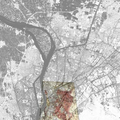
Now we have to define reference points (ground control points / GCPs) in both images. Select (activate) image Cairo_Landsat_2000_Band_321.tif. Set the first point, switch to image Cairo_1874.jpg, look for the same position and set the first point there. Both coordinates appear in the GCPs Collection. Go back to Cairo_Landsat_2000_Band_321.tif and select the second point, switch to Cairo_1874.jpg and select the same position. Do so with at least 4 to 5 points. Tip: Open image Cairo_1874_GEO.jpg and print it. 5 useful positions for georeferencing are marked. Transfer the positions of the 5 marked points to Cairo_Landsat_2000_Band_321.tif and Cairo_1874.jpg as explained above. Choose Options>Warp Image from the GCPs Collection.
The new image is now on the same scale and orientation as the Landsat dataset. Save the image as Cairo_1874_REF (TIF) in the folder Cairo.
Choose File>Open. A dialogue box will pop up. Choose the folder Cairo and select image Cairo_Landsat_2000_Band_5.tif. The image needs to be improved with respect to brightness and contrast. Choose Enhance>Histogram Equalization. The image will change. Choose Image>Transparent Overlay. Select Cairo_Landsat_2000_Band_5.tif as BackGround Image and Cairo_1874_REF.tif as ForeGround Image and bring the Opacity-slide to 50%.
Look at the position of islands and roads. Does the historical map of Cairo fit onto the satellite image? If not, you have to do the exercise again.
Last update: 16 April 2013
| ||||||||||||||||||||||||||||||||||||||||||||||||||||||||||||||||||||||||||||