|
Ngorongoro Conservation Area - background
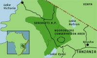
The NCA, together with the Serengeti National Park, forms a large area in the Northern part of Tanzania.
The Ngorongoro Conservation Area is part of UNESCO's list of 144 Natural World Heritage sites. A large, permanent concentration of wild animals can be found in the huge, perfect crater of Ngorongoro. The Empakaai crater, filled by a deep lake, and the Oldonyo Lenga active volcano can both be seen nearby. Excavations carried out in the Olduvai gorge have resulted in the discovery of one of our most distant ancestors, Homo habilis. The Laitoli Site, which also lies within the area, is one of the main locations of early hominid footprints, dating back 3.6 million years.
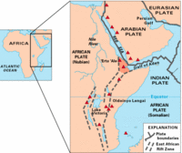
Two hundred million years ago, the Pangea super-continent started to split, leading to the creation of the continents as we know them today. About 70 million years ago, the outline of the African continent was drawn and had taken the position it now occupies. Fifteen to 20 million years ago, the massive and constant movement in the Earth's crust tore a fracture through much of Africa, from the Red Sea to the Kalahari in Namibia. This resulted in the 6400 km long African or Great Rift Valley. The fractures in the rift valley allowed molten rock to reach the surface of the Earth, giving rise to the volcanoes we have today. Ngorongoro lies in northern Tanzania in what was once volcanic terrain. To the east is the Gregory Rift Valley, the source of the Manyara and Natron salt lakes, famous for their flamingoes and Africa's highest peak, Mount Kilimanjaro. Only one volcano, Oldoinyo Lengai (Maasai for the Mountain of God), is still occasionally active.
The centrepiece of Ngorongoro is in fact a caldera - the largest unflooded and unbroken one in the world - and not a crater as it is usually called. A caldera has a diameter several times the size of the vent through which a volcano once spewed forth its debris of ash over the surrounding countryside. A caldera is formed by the inward collapse of the volcano.
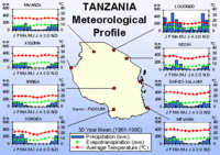
Ngorongoro, just like most of East Africa, has two distinct and independent periods of rain each year - the short rains of November and December, and the long, usually more intense rains from March to May. These rains are dependent upon two Indian monsoons which carry inland moisture-bearing clouds that are broken up by the high ground they encounter. The short rains tend to come from the northeast, while the long rains come from the southeast. As these rain clouds make their way from the sea, they must cross many mountain ranges, and therefore lose much of their moisture, before reaching Ngorongoro.
At Ngorongoro, the bulk of the rain falls on the eastern and southern slopes, nurturing the forest reserve, interspersed with grassy clearings. In contrast, the western side of Ngorongoro receives comparatively little moisture and the area is described as being in a 'rain shadow'.
Satellite images We will use two Landsat 7 images for this exercise: Click to download Landsat images from 2000 (6,0 Mb).
25 October 2000 Click to download Landsat images from 2001 (6,0 Mb).
14 February 2001 The image size is 1100 pixels × 1300 pixels. We recommend you store the unzipped images in a data folder in LEOWorks. Click to download Landsat images from 2000 and 2001 covering the Western part of NCA (1.9 Mb).
25 October 2000
14 February 2001
The image size is 512 pixels x 512 pixels Image Processing software The LEOWorks image processing software can be used to analyse satellite images. Last update: 16 April 2013
| ||||||||||||||||||||||||||||||||||||||||||||||||||||||||||||||||