| |
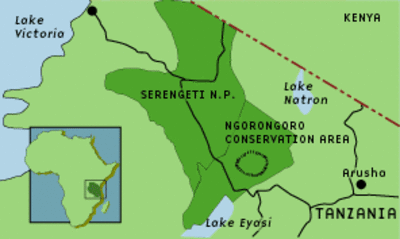
Ngorongoro Conservation Area
|
| • | Informazioni generali (http://www.esa.int/SPECIALS/Eduspace_Global_IT/SEMU4ORJR4G_0.html) |
|
Esercizi
|
| • | Analisi delle immagini (http://www.esa.int/SPECIALS/Eduspace_Global_IT/SEMREORJR4G_0.html) |
|
Links
|
| • | The World Factbook - Tanzania (https://www.cia.gov/library/publications/the-world-factbook/geos/tz.html) |
|
| • | Unesco World Heritage List (http://whc.unesco.org/en/list) |
|
| • | UNESCO World Heritage List - Ngorongoro Conservation Area (http://whc.unesco.org/en/list/39) |
|
| • | Monitoring weather and climate from space (http://www.eumetsat.int/Home/Main/Image_Gallery/index.htm?l=en) |
|
Eduspace - Software
|
| • | LEOWorks 3 (http://esamultimedia.esa.int/multimedia/LEOWorks3.exe) |
|
Eduspace - Download
|
| • | Landsat images from 2000 (6.0 Mb) (http://esamultimedia.esa.int/docs/eduspace/Ngorongoro_00.zip) |
|
| • | Landsat images from 2001 (6.0 Mb) (http://esamultimedia.esa.int/docs/eduspace/Ngorongoro_01.zip) |
|
| • | Landsat images from 2000 and 2001 covering Western part of NCA (1.9 Mb) (http://esamultimedia.esa.int/docs/eduspace/NGO_West.zip) |
|